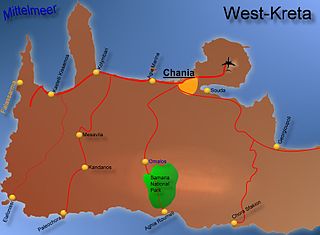
The Samariá Gorge is a National Park of Greece since 1962 on the island of Crete – a major tourist attraction of the island – and a World's Biosphere Reserve.
Agia Eirini may refer to several places in Cyprus and Greece:
Hóra Sfakíon or Sfakia is a town on the south coast of Crete, Greece. It is the capital of the remote and mountainous region of Sfakiá, and is a small town of just 265 inhabitants. It lies on the south coast near the end of the Imbros Gorge, 74 km south of Chania. It has two small harbours, where the ferry boats from Agia Roumeli dock, which in the summer bring the hikers from the Samaria Gorge to take buses back to the northern coast. From Hóra Sfakíon ferries also go to the nearby coastal town of Loutro and the island Gavdos.

Palaiochora is a small town in Chania regional unit, Greece. It is located 77 km south of Chania, on the southwest coast of Crete and occupies a small peninsula 400m wide and 700m long. The town is set along 11 km of coastline bordering the Libyan Sea. It is the seat of the municipality of Kantanos–Selino and its population was 1,675 in the 2011 census.

Chania is one of the four regional units of Crete; it covers the westernmost quarter of the island. Its capital is the city of Chania. Chania borders only one other regional unit: that of Rethymno to the east. The western part of Crete is bounded to the north by the Cretan Sea, and to the west and south by the Mediterranean Sea. The regional unit also includes the southernmost island of Europe, Gavdos.

Agia Roumeli is a small village in southwest Crete, Greece and is popular with tourists.

The Kourtaliotiko Gorge, also known as the Asomatos Gorge (Greek: Φαράγγι Ασώματου), is a gorge on the southern side of the western part of the island of Crete. It is situated where the Kourtaliotiko River flows southwards between the mountains of Kouroupa and Xiron.

The Kotsifos Gorge is a gorge on the southern side of the western part of the island of Crete. It is situated west of the mountain of Kouroupa, north of the town of Plakias, and on the road between Sellia and Angouseliana. It is noted for the high number of Cretan endemic plant species that grow there.

East Selino is a former municipality in the Chania regional unit, Crete, Greece. Since the 2011 local government reform it is part of the municipality Kantanos-Selino, of which it is a municipal unit. The municipal unit has an area of 136.555 km2 (52.724 sq mi). It is situated on the south-west coast of the island of Crete. It was part of the former Selino Province which covered the mountain and coastal region west of Sfakia. The seat of the municipality was Kampanos.

Pelekanos is a former municipality in the Chania regional unit, Crete, Greece. Since the 2011 local government reform it is part of the municipality Kantanos-Selino, of which it is a municipal unit. The municipal unit has an area of 166.618 km2 (64.332 sq mi). Pelekanos is in the south west corner of the island, part of the rugged and remote Selino Province. The Venetians built a castle - Kastel Selinou - at Palaiochora, giving the region its name. Palaiochora is now a growing coastal resort and the capital town of the municipality.

Theriso is a village and former municipality in the Chania regional unit, Crete, Greece. Since the 2011 local government reform it is part of the municipality Chania, of which it is a municipal unit. The municipal unit has an area of 74.106 km2 (28.612 sq mi). It was part of the former Kydonia Province, which covered the central part of Chania Prefecture.
Imbros Gorge is an 11 km long canyon located near Hora Sfakion in southern Crete, the Mediterranean island. It runs parallel to Samariá Gorge, its narrowest part has 1.60 m and it ends at the village of Kommitádes. The Imbros village is located at an altitude of 780 meters and is at the South end of the fertile plain of Askyfou.
Sougia is a community and a small village in Chania regional unit on the island of Crete, Greece. It is part of the municipal unit of East Selino. It is located on the south coast of the island, 70 km south of Chania. The community consists of the following villages :
Epanochori is a community and a small village in Chania regional unit on the island of Crete, Greece. It is part of the municipal unit of East Selino. The community consists of the following villages :
Agia Eirini is a small community in Western Crete, population 80. It lies in the Chania regional unit which constitutes the western part of Crete. It is in the municipality of Kantanos-Selino, which forms the southwest part of the region, specifically the East Selino unit, and the community of Epanochori.

Loutro lies on the south coast of Chania regional unit in west Crete, between Chora Sfakion and Agia Roumeli, the exit to the Samaria Gorge. The whole area is known as Sfakia. The village got its name from the Greek word for "bath," for the many ancient baths found in the area.
Hyrtacina or Hyrtakina, also written as Hyrsacina or Hyrsakina (Ὑρσακίνα), or Artacina or Artakina (Ἀρτάκινα), was a city of ancient Crete, which, little as we learn of its position from Ptolemy and Stephanus of Byzantium, yet we may safely infer from the former's words that it was situated to the southeast of Polyrrhenia, and to the west of Lappa. The Periplus of Pseudo-Scylax teaches us more respecting its site; it places it on the south of the island, and to the south of the Dictynnean temple of Artemis and the Pergamian district. These indications agree well with the situation of the ruins discovered by Robert Pashley on Kastri hill between the existing villages Temenia and Papadiana.

Argoules is a semi-mountainous hamlet in Sfakia municipality on the island of Crete, Greece. It is the easternmost settlement of the Chania regional unit, located at a distance of about 85 km from the city of Chania. The time of its establishment is unknown, however Argoules is mentioned in Venetian registers as early as the sixteenth century (1577), belonging to the Territorio di Rettimo.
Omalos is a small village in western Crete, in the Mousouroi unit of the Chania region. The Greek word Ομαλός means even, plain, regular, or smooth, referring to the plateau.
Kounaviano Gorge is a gorge near Heraklion, Crete.


