Related Research Articles
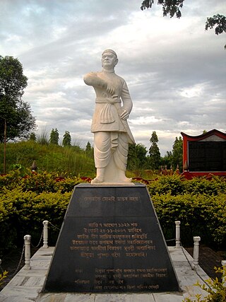
Lachit Borphukan was an Ahom Borphukan, primarily known for commanding the Ahom Army and the victory in the Battle of Saraighat (1671) that thwarted an invasion by the vastly superior Mughal Forces under the command of Ramsingh I. He died about a year later in April 1672.

The Battle of Saraighat was a naval battle fought in 1671 between the Mughal Empire, and the Ahom Kingdom on the Brahmaputra river at Saraighat, now in Guwahati, Assam, India. The Ahoms, smarting from the occupation of the capital by Mir Jumla and the harsh conditions of Treaty of Ghilajharighat, decided to lure a Mughal imperial force to Saraighat and take a stand there. Although weaker, the Ahom Army defeated the Mughal Army by massive army, clever diplomatic negotiations to buy time, guerrilla tactics, psychological warfare, military intelligence and by exploiting the weakness of the Mughal forces—its navy.

The history of Assam is the history of a confluence of people from the east, west, south and the north; the confluence of the Austroasiatic, Tibeto-Burman (Sino-Tibetan), Tai and Indo-Aryan cultures. Although invaded over the centuries, it was never a vassal or a colony to an external power until the third Burmese invasion in 1821, and, subsequently, the British ingress into Assam in 1824 during the First Anglo-Burmese War.
Koch Hajo (1581-1616) was the kingdom under Raghudev and his son Parikshit Narayan of the Koch dynasty that stretched from Sankosh river in the west to the Bhareli river in the east on the north bank of the Brahmaputra river. It was created by dividing the Kamata kingdom then under Nara Narayan in medieval Assam. The Sankosh river divided the two new kingdoms, and it is roughly the boundary between the present-day Assam and West Bengal. The western half of the Kamata kingdom emerged as Koch Bihar whereas the eastern half emerged as Koch Hajo. The name Hajo comes from the legendary king Hajo, a Koch tribal chief and an ancestor of the Koch dynasty, who ruled over the Rangpur division in present-day Bangladesh and some regions of present-day Assam.
The Moamoria rebellion (1769–1805) was an 18th-century uprising in Ahom kingdom of present-day Assam that began as power struggle between the Moamorias (Mataks), the adherents of the Mayamara Sattra, and the Ahom kings. This uprising spread widely to other sections of Ahom kingdom including disgruntled elements of the Ahom aristocracy leading to two periods in which the Ahom king lost control of the capital. Retaking the capital was accompanied by a massacre of subjects, leading to a steep depopulation of large tracts. The Ahom king failed to retake the entire kingdom; a portion in the north-east, Bengmara, became known as Matak Rajya ruled by a newly created office called Borsenapati, became a tribute-paying but virtually independent territory.

Susenghphaa or Pratap Singha, was the 17th and one of the most prominent kings of the Ahom kingdom. As he was advanced in years when he became king, he is also called the burha Raja. His reign saw an expansion of the Ahom kingdom to the west, the beginning of the Ahom-Mughal conflicts, and a reorganization of the kingdom with an expanded Paik system and reoriented village economy designed by Momai Tamuli Borbarua. His expansion to the west is underlined by the two new offices that he created: that of the Borbarua and the Borphukan. The alliances he formed with the rulers of Koch Hajo resulted in formation that successfully thwarted Mughal expansion. The administrative structure that he created survived until the end of the Ahom kingdom in 1826.

The Ahom kingdom was a late medieval kingdom in the Brahmaputra Valley that retained its independence for nearly 600 years despite encountering Mughal expansion in Northeast India. Established by Sukaphaa, a Tai prince from Mong Mao, it began as a mong in the upper reaches of the Brahmaputra based on wet rice agriculture. It expanded suddenly under Suhungmung in the 16th century and became multi-ethnic in character, casting a profound effect on the political and social life of the entire Brahmaputra valley. The kingdom became weaker with the rise of the Moamoria rebellion, and subsequently fell to repeated Burmese invasions of Assam. With the defeat of the Burmese after the First Anglo-Burmese War and the Treaty of Yandabo in 1826, control of the kingdom passed into East India Company hands.

Ahom–Mughal conflicts (1616–1682) refers to the series of 17th-century conflicts between the Ahoms and the Mughals over the control of the Brahmaputra valley. It began soon after the eastern branch of the Kamata kingdom then under the Koch dynasty, Koch Hajo, collapsed after a sustained Mughal campaign bringing it face-to-face with the eastern Ahoms. After nearly seventy years of sustained efforts, the Mughals were finally ousted in the Battle of Itakhuli in 1682. The Mughals since then maintained interest to the region west of the Manas river via zamindars, till they were ousted from Bengal by the British about a hundred years later.
Choapha Supatpha also Swargadeo Gadadhar Singha, was the twenty-ninth king of Ahom kingdom, who reigned from 1681 to 1696. He established the rule of Tungkhungia royal house of Ahom kings, whose descendants continued to rule till the climactic end of the Ahom kingdom in 1826. He was earlier known as Gadapani Konwar and was a son of Gobar raja, a descendant of Suhungmung, and who had become king for twenty days. Gadadhar Singha stabilized the Ahom kingdom, which was going through a long decade of political turmoil and instability. This period saw the ruthless power grab of Debera Borbarua and Laluksola Borphukan's abandonment of Guwahati to the hands of Mughals and oppression via Sulikphaa alias Lora Roja.
Borphukan was one of the five patra mantris (councillors) in the Ahom kingdom, a position that was created by the Ahom king Prataap Singha. The position included both executive and judicial powers, with jurisdiction of the Ahom kingdom west of Kaliabor river. The headquarters of Borphukan was based in Kaliabor and after the Battle of Itakhuli in 1681 in Itakhuli in Guwahati. This position was particularly important and powerful because of its distance from the Ahom capital, giving it a semblance of independence. The region to the east of Kaliabor was governed by the Borbarua. Lachit Deka later became Borphukan or the ruler of Lower Assam according to the fifth chronicles of the Satsori Asom Buranji.
Supangmung, also known as Chakradhwaj Singha, was an important Ahom king under whom the Ahom kingdom took back Guwahati from the Mughals following the reverses at the hands of Mir Jumla and the Treaty of Ghilajharighat. He is known for his fierce pride as an Ahom monarch.
The Paik system was a type of corvee labour system on which the economy of the Ahom kingdom of medieval Assam depended. In this system, adult and able males, called paiks were obligated to render service to the state and form its militia in return for a piece of land for cultivation owned by the kingdom—believed to be a legacy the Ahoms brought with them from South-Eastern Asia in 1228. But it wasn't the Ahom kingdom alone that used a corvee system like this in Northeast India—Kingdom of Manipur and in a simpler form Jaintia kingdom and the Kachari kingdom too used similar systems that had tribal origins. The mature structure was designed by Momai Tamuli Borbarua in 1608, and extensively and exhaustively implemented by 1658 during the reign of Sutamla Jayadhwaj Singha. The system continued to evolve over time to meet the needs of the Ahom state and in time began to accumulate contradictions. By the end of the Moamoria rebellion (1769–1805) the Paik system had collapsed.

Kamrup is the modern region situated between two rivers, the Manas and the Barnadi in Western Assam, with the same territorial extent as the Colonial and post-Colonial "Undivided Kamrup district". It was the capital region of two of the three dynasties of Kamarupa and Guwahati, the current political center of Assam, is situated here. It is characterized by its cultural artifacts.
Undivided Kamrup district is a former administrative district located in Western Assam from which Kamrup Rural (2003), Kamrup Metropolitan (2003), Barpeta (1983), Nalbari (1985) and Baksa (2004) districts were formed. It was announced in January 2020 that the Bajali sub-division of Barpeta district will be upgraded to a full district.
The Battle of Itakhuli was fought in 1682 between the Ahom Kingdom and the Mughal Empire. The Ahoms pushed back Mughal control to the west of the Manas river. The main battle was fought at a garrison island on the Brahmaputra, in which the Mughal fauzdar, Mansur Khan, was defeated and the remnant of the Mughal forces pursued to the Manas river. With this win, the Ahoms recovered Sarkar Kamrup from the Mughals.
The Undivided Goalpara district is an erstwhile district of Assam, India, first constituted by the British rulers of Colonial Assam.
Ramani Gabharu, was the princess of Kingdom of Assam and the first wife of titular Mughal emperor Muhammad Azam Shah. She was sent to the Mughal harem as part of the Treaty of Ghilajharighat and was renamed Rahmat Banu Begum.
Bora, also spelled Borah or Barah, is an Assamese surname used commonly throughout Assam.
The Invasions of Assam by Islamic rulers began in 1206 when the Turko-Afghan Muhammad-i-Bakhtiyar passed through Kamarupa against Tibet. The last attempt was the Battle of Saraighat in 1671 under Mughal emperor Aurangzeb. The Ahom kingdom removed the vestigial Mughal power from Western Assam up to the Manas river in 1682 after the Battle of Itakhuli.

Momai Tamuli Borborua (?–1650) also known by his birth name Sukuti was an able Ahom general, statesman, and noble and the first incumbent to the office of the Borbarua. He is popularly known for systemizing the paik system and for being the father of famous Ahom general Lachit Borphukan.
References
- Richards, John F. (1995). The Mughal Empire. Cambridge: Cambridge University Press. ISBN 0521566037 . Retrieved January 26, 2013.