
The Arabian Sea is a region of sea in the northern Indian Ocean, bounded on the west by the Arabian Peninsula, Gulf of Aden and Guardafui Channel, on the northwest by Gulf of Oman and Iran, on the north by Pakistan, on the east by India, and on the southeast by the Laccadive Sea and the Maldives, on the southwest by Somalia. Its total area is 3,862,000 km2 (1,491,000 sq mi) and its maximum depth is 5,395 meters. The Gulf of Aden in the west connects the Arabian Sea to the Red Sea through the strait of Bab-el-Mandeb, and the Gulf of Oman is in the northwest, connecting it to the Persian Gulf.

The Persian Gulf, sometimes called the Arabian Gulf, is a mediterranean sea in West Asia. The body of water is an extension of the Indian Ocean located between Iran and the Arabian Peninsula. It is connected to the Gulf of Oman in the east by the Strait of Hormuz. The Shatt al-Arab river delta forms the northwest shoreline.
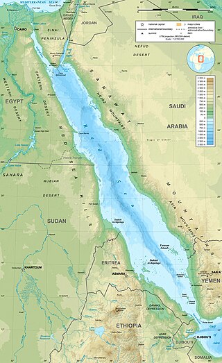
The Red Sea is a sea inlet of the Indian Ocean, lying between Africa and Asia. Its connection to the ocean is in the south, through the Bab-el-Mandeb strait and the Gulf of Aden. To its north lie the Sinai Peninsula, the Gulf of Aqaba, and the Gulf of Suez—leading to the Suez Canal. It is underlain by the Red Sea Rift, which is part of the Great Rift Valley.

The Gulf of Aden is a deepwater gulf of the Indian Ocean between Yemen to the north, the Arabian Sea to the east, Djibouti to the west, and the Guardafui Channel, the Socotra Archipelago, Puntland in Somalia and Somaliland to the south. In the northwest, it connects with the Red Sea through the Bab-el-Mandeb strait, and it connects with the Arabian Sea to the east. To the west, it narrows into the Gulf of Tadjoura in Djibouti. The Aden Ridge lies along the middle of the gulf, and tectonic activity at the ridge is causing the gulf to widen by about 15 mm (0.59 in) per year.

The Bab-el-Mandeb, the Gate of Grief or the Gate of Tears, is a strait between Yemen on the Arabian Peninsula and Djibouti and Eritrea in the Horn of Africa. It connects the Red Sea to the Gulf of Aden and by extension the Indian Ocean.

Cape Guardafui is a headland in the federal state of Puntland in Somalia. Coextensive with Puntland's Gardafuul administrative province, it forms the geographical apex of the Horn of Africa. Its shore at 51°27'52"E is the second easternmost point on mainland Africa after Ras Hafun. The offshore oceanic strait Guardafui Channel is named after it.

The Gulf of Suez is a gulf at the northern end of the Red Sea, to the west of the Sinai Peninsula. Situated to the east of the Sinai Peninsula is the smaller Gulf of Aqaba. The gulf was formed within a relatively young but now inactive Gulf of Suez Rift rift basin, dating back about 26 million years. It stretches some 300 kilometres (190 mi) north by northwest, terminating at the Egyptian city of Suez and the entrance to the Suez Canal. Along the mid-line of the gulf is the boundary between Africa and Asia. The entrance of the gulf lies atop the mature Gemsa oil and gas field. The gulf is considered one of the world's important maritime zones due to being an entrance to the Suez Canal.

The Gulf of Aqaba or Gulf of Eilat is a large gulf at the northern tip of the Red Sea, east of the Sinai Peninsula and west of the Arabian Peninsula. Its coastline is divided among four countries: Egypt, Israel, Jordan, and Saudi Arabia. The northernmost coral reef in the world is situated near the Eilat shore.
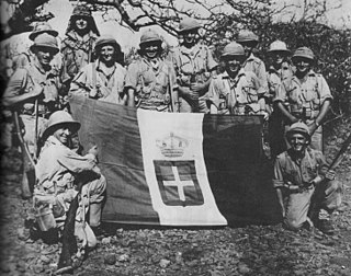
The East African campaign was fought in East Africa during the Second World War by Allies of World War II, mainly from the British Empire, against Italy and its colony of Italian East Africa, between June 1940 and November 1941. The British Middle East Command with troops from the United Kingdom, South Africa, British India, Uganda Protectorate, Kenya, Somaliland, West Africa, Northern and Southern Rhodesia, Sudan and Nyasaland participated in the campaign. These were joined by the Allied Force Publique of Belgian Congo, Imperial Ethiopian Arbegnoch and a small unit of Free French Forces.
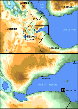
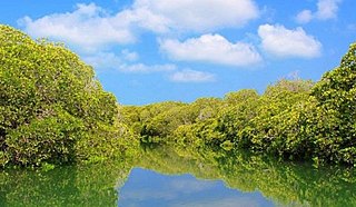
The Gulf of Tadjoura is a gulf or basin of the Indian Ocean in the Horn of Africa. It lies south of the straits of Bab-el-Mandeb, or the entrance to the Red Sea, at 11.7°N 43.0°E. The gulf has many fishing grounds, extensive coral reefs, and abundant pearl oysters. Most of its coastline is the territory of Djibouti, except for a short stretch on the southern shore, which is part of the territory of Somaliland.
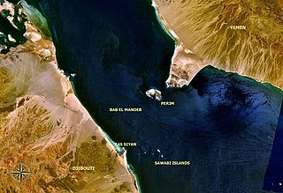
Perim, also called Mayyun in Arabic, is a Yemeni volcanic island in the Strait of Mandeb at the south entrance into the Red Sea, off the south-west coast of Yemen. It administratively belongs to Dhubab District or Bab al-Mandab District, Taiz Governorate. The island of Perim divides the strait of Mandeb into two channels.

Shadwan is a barren rocky island 30 miles southwest of the Egyptian city of Sharm el-Sheikh on the Sinai Peninsula and 20 miles northeast of El Gouna. It is the largest of a group of islands in the mouth of the Gulf of Suez in the northern Red Sea and measures 16 kilometres (9.9 mi) in length, and between 3 and 5 kilometres wide. It was formerly also called Shaker Island and features a lighthouse. The island is famous as a touristic site for underwater diving and fishing.
The Bab Iskender (Arabic: باب اسكندر Iskander's Strait, also variously known as the Eastern strait, the small strait, the narrow pass or the small pass, is the eastern section of the Bab-el-Mandeb straits, which separates Ras Menheli, Yemen, on the Arabian Peninsula from Ras Siyyan, Djibouti, on the Horn of Africa. The strait is 2 miles wide and 16 fathoms deep. The Yemeni island of Perim divides the strait into two channels, Bab Iskender and Dact-el-Mayun respectively.
Ras Siyyan or Ras Siyan is a peninsula in the Obock Region of Djibouti, on the Bab-el-Mandeb strait, about 20 km southwest of Perim Island.

Maydh is an ancient port city in the eastern Sanaag region of Somaliland.

Djibouti, officially the Republic of Djibouti, is a country in the Horn of Africa, bordered by Somalia to the south, Ethiopia to the southwest, Eritrea in the north, and the Red Sea and the Gulf of Aden to the east. The country has an area of 23,200 km2 (8,958 sq mi).
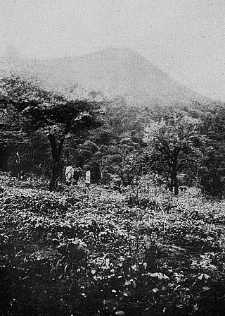
The Mabla Mountains are a mountain range in the northern Obock and Tadjoura Region of Djibouti. The endemic Djibouti spurfowl makes its home here as well as in the Forêt du Day. With a mean height of 1370 metres, is the fifth highest point in Djibouti.
The 1969 Sharm El Sheikh earthquake occurred on March 31 off the southern Sinai Peninsula in northeastern Egypt. The epicenter was located near Shadwan island, southwest of the city of Sharm El Sheikh, at the confluence of the Red Sea and the Gulf of Suez. This normal-slip shock measured 6.6 on the moment magnitude scale, had a maximum reported intensity of VII on the Mercalli intensity scale, and was responsible for several deaths and injuries.

The Sa'ad ad-Din Islands, also Romanized as Sa'ad-ed-din and known as the Zeila Archipelago, are a group of islands off the northwestern coast of Somalia. They are situated near the ancient city of Zeila.
Sacadin is the largest of the six Somaliland islands of the Zeila Archipelago, off the coast of Somaliland. It has an area of 7.2 square kilometers and is mostly desert, although 2 portions of the island have abundant vegetation. It is 11.5 kilometers long and is located 5.4 kilometers north of the coast of Somaliland, near the border with Djibouti.


