Related Research Articles

Kukenan Falls is the second tallest major waterfall in Venezuela after Angel Falls. It is also the second tallest free-leaping waterfall in the world. Overall, it is usually cited as the 11th highest waterfall in the world. The falls drop in a single leap of around 2,211 feet (674 m) and the final portion of the falls trickles down towards the base of the Kukenan Tepui.
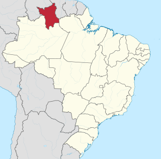
Roraima is one of the 26 states of Brazil. Located in the country's North Region, it is the northernmost and most geographically and logistically isolated state in Brazil. It is bordered by the state of Pará to the southeast, Amazonas to the south and west, Venezuela to the north and northwest, and Guyana to the east.
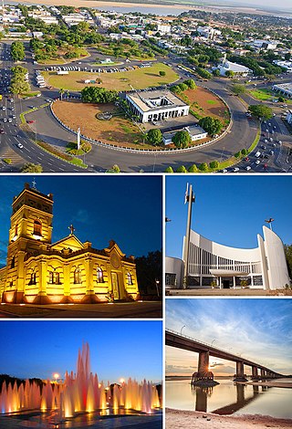
Boa Vista is the capital of the Brazilian state of Roraima. Situated on the western bank of the Branco River, the city lies 220 km (140 mi) from Brazil's border with Venezuela. It is the only Brazilian state capital located entirely north of the equator.
The Pacaraima or Pakaraima Mountains are a mountain range primarily in southwestern Guyana, and into northern Brazil and eastern Venezuela.

The Ireng River forms part of Guyana's western border with Brazil. It flows through the valleys of the Pakaraima Mountains for most of its length. It is the only major river in Guyana which flows from North to South, up to its confluence into the Takutu River. It is one of the northernmost tributaries of the Amazon river system.
Arutani is a nearly extinct language spoken in Roraima, Brazil and in the Karum River area of Bolivar State, Venezuela. There are only around 6 speakers left.
The Canton of Saint-François is a canton in the Arrondissement of Pointe-à-Pitre on the island of Guadeloupe.
Jufari River is a river forming part of the border between Amazonas and Roraima states in north-western Brazil.
The Auari River is a river of Roraima state in northern Brazil.
The Branquinho River is a river of Roraima state in northern Brazil.
The Caju River is a river of Roraima state in northern Brazil.
The Caroaebe River is a river of Roraima state in northern Brazil, near the equator.
The Catrimani River is a river of Roraima state in northern Brazil.
The Furo Santa Rosa is a river of Roraima state in northern Brazil. It is an anabranch - a diversionary channel - of the Uraricoera River; together they bound the Ilha de Maracá.
The Macucuaú River is a river of Roraima state in northern Brazil.
The Surumu River is a river of Roraima state in northern Brazil.
The Traida River is a river of Roraima state in northern Brazil.
The Xeriuini River is a river located in the Roraima state in northern Brazil.
The Água Boa do Univini River is a river of Roraima state in northern Brazil.
The Ailã River is a river of Roraima state in northern Brazil. It is located in Monte Caburaí, in the municipality of Uiramutã. Its source is the northernmost point of Brazil.
References
Coordinates: 1°32′53″N61°15′04″W / 1.54806°N 61.25111°W