
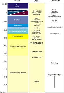
Samad al-Shan is an archaeological site in the Sharqiyah province, Oman where Late Iron Age remains were first identified, hence the Samad Period or assemblage.
Izki is a town in the region Ad Dakhiliyah, northeastern Oman. It is located at c. 544 m (1,785 ft) altitude, and has a population of 35,173 (2003 census).
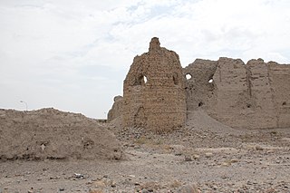
Ẓafār or Dhafar Ðafār is an ancient Himyarite site situated in Yemen, some 130 km south-south-east of today's capital, Sana'a, and c. 10 kilometres (6.2 mi) southeast of Yarim. Given mention in several ancient texts, there is little doubt about the pronunciation of the name. Despite the opinion of local patriots in Oman, this site in the Yemen is far older than its namesake there. It lies in the Yemenite highlands at some 2800 m. Zafar was the capital of the Himyarites, which at its peak ruled most of the Arabian Peninsula. The Himyar are not a tribe, but rather a tribal confederacy. For 250 years the confederacy and its allies combined territory extended past Riyadh to the north and the Euphrates to the north-east. Zafar was the Himyarite capital in Southern Arabia prior to the Aksumite conquest.
The present-day Sultanate of Oman lies in the south-eastern Arabian Peninsula. There are different definitions for Oman: while traditional Oman also includes the present-day United Arab Emirates, its prehistoric remains differ in some respects from the more specifically defined Oman proper, which corresponds roughly with the present-day central provinces of the Sultanate. In the north, the Oman Peninsula is more specific, and juts into the Strait of Hormuz. The archaeology of southern Oman Ẓafār develops separately from that of central and northern Oman.

Amlah or ʿAmlāʾ, al-Dhāhirah province, Sultanate of Oman. The area around Amlah contains numerous archaeological sites which came to light during surveys in the mid 1970s. Those that are available to the public date from the Bronze Age Wadi Suq period to the late pre-Islamic period. 26 excavated graves provide evidence for a cemetery at al-Fuwaydah. The graves and grave goods are related most closely to those of the United Arab Emirates, Preislamique Récente, i.e. PIR, and not the Samad Late Iron Age. Among the most striking Late Iron Age finds are bronze phiales inscribed on the inside..

Archaeological site in Oman.

Bawshar is one of the wilayats of Muscat, in northeastern Oman. The province borders wilayat Muttrah in the east and Muscat International Airport in the west, it overlooks the Sea of Oman from the north. It contains several archaeological sites.
Gerd Weisgerber was an eminent German professor of mining archaeology. He was one of the first mining archaeologists of the world, who set standards in this scientific discipline. As a scientist from the German Mining Museum, he focused his research mainly on Western Asia, especially on Oman, Jordan, Palestine, and Iran.

Qaryat al-Saiḥ in Wadi Maḥram is an archaeological site in Samaʾīl Wilayat Sharqiyah, in Central Oman. This fortified village was inhabited in the Samad Late Iron Age and during Islamic times.
Umq al-Rabach, al-Sharqiyah, Sultanate of Oman is an archaeological site of the Samad Late Iron Age and Islamic Periods.

ʿUqdat al-Bakrah, also known incorrectly as Al-Saffah, is an archaeological site in Wadi Dhank, in the Muḥāfaẓat aẓ-Ẓāhirah region of northwestern Oman. It is a metal-working site dating to the Early Iron Age.
Al-Nejd is an archaeological site in Ash Sharqiyah, Oman. It was a fortified village inhabited during the Samad Late Iron Age and possibly during Islamic times. The site was discovered in 2014 following the chance find of a coin by a local resident, and was then confirmed and dated by a team from the Ministry of Heritage and Culture. The site yielded the first tetradrachm of Abiel type, which was struck in what is now the United Arab Emirates. The coin is on display in the National Museum in Muscat.

Al-Amqat is an archaeological site in al-Dakhaliyah, Oman. Located on a slope to the north of the oasis, the cemetery dates to the Samad Late Iron Age.

Al-Akhdhar is an archaeological site in Ash Sharqiyah, Oman. It is a cemetery containing with remains dating from the Umm al-Nar, Wadi Suq, Late Iron Age (Samad), and Islamic periods.

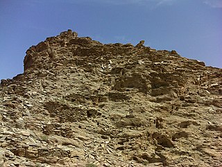
Lizq is an archaeological site in Ash Sharqiyah, Oman. Located on a mountain lying in a plain, 1000 m south-east of the south-eastern edge of the Lizq palm garden, the fort dates to the Lizq-Rumaylah/Early Iron Age.

Ṭīwī is a town in Oman. It is known for an archaeological site in the area known as al-Jurayf, in Ṣūr Wilayat Sharqiyah. The town and the site are located between Wadi Shab and Wadi Tiwi on the Gulf of Oman.
al-Moyassar is an archaeological zone in the Sharqiyah province, Oman where the remains of all pre-Islamic periods came to light. The geographic definition has changed in recent years for this irregular area which measures some 2 x 5 km. It lies directly west of the Samad oasis.

The Recent Pre-Islamic Period is an archaeological assemblage which is manifest in the few centuries around the year 0 in the lower Arabian/Persian Gulf. It was discovered in the mid 1970s by Iraqi archaeologists. Some nine such sites are known at present especially ed-Dur in the Emirate Umm al-Qaiwain, and Mleiha in Sharjah in the Oman peninsula. Since the mid 1980s different teams studied especially these two sites, which are the largest in terms of surface area. They contain settlements, religious and industrial areas as well as cemeteries loosely scattered over a wide area. Mlayḥa forms an irregularly shaped surface of c. 4 km2. Two PIR sites have been identified in Central Oman, at Samāʾil/al-Bārūnī and at ʿAmlāʾ/al-Fuwaydah.
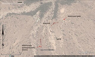
Jebel al-Salayli, is an archaeological site in the Sharqiyah province of the Sultanate of Oman, where a large number of Early Iron Age so-called hut tombs were first mentioned publicly. The first citation mistakenly refers to this site as 'Musfa', a site which actually lies a few kilometres to the north. The Jebel is the adjacent mountain to the immediate north. The Jebel al-Salayli site attracted the attention of archaeologists because of an abandoned copper mine, extensive slag fields, ruined settlements and numerous Early Iron Age tombs. Nestled between the mountains, this site is still relatively well preserved. The settlement ruins date to the Early Iron Age and the Muslim Period. At the lower end of a wadi, the hut tombs, designated stie 1, lie 400 m west of an abandoned copper mine, to which they probably originally owed their existence.


