Al-Qahtaniyah, Raqqa Governorate

Last updated
Al-Qahtaniya
القحطانية
Village
Syria adm location map.svg
Red pog.svg
Al-Qahtaniya
Location in Syria
Coordinates: 35°59′37″N38°55′52″E / 35.99361°N 38.93111°E / 35.99361; 38.93111
CountryFlag of Syria.svg  Syria
Governorate Raqqa Governorate
District Raqqa District
Nahiyah Raqqa
Occupation Flag of Rojava.svg Rojava
Population (2004 census) [1]
  Total 2,490
Time zone EET (UTC+3)
  Summer (DST) EEST (UTC+2)

Al-Qahtaniya (Arabic : القحطانية) is a village in northern Syria, administratively part of Raqqa Governorate, located just northwest of Raqqa. According to the Syria Central Bureau of Statistics (CBS), al-Qahtaniya had a population of 2,490 in the 2004 census. [1]

Syria Country in Western Asia

Syria, officially the Syrian Arab Republic, is a country in Western Asia, bordering Lebanon to the southwest, the Mediterranean Sea to the west, Turkey to the north, Iraq to the east, Jordan to the south, and Israel to the southwest. A country of fertile plains, high mountains, and deserts, Syria is home to diverse ethnic and religious groups, including Syrian Arabs, Greeks, Armenians, Assyrians, Kurds, Circassians, Mandeans and Turks. Religious groups include Sunnis, Christians, Alawites, Druze, Isma'ilis, Mandeans, Shiites, Salafis, Yazidis, and Jews. Sunni make up the largest religious group in Syria.

Raqqa Governorate Governorate in Syria

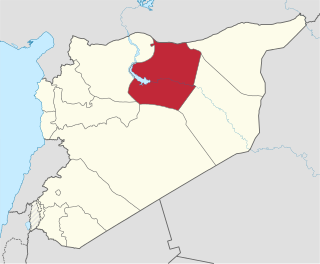
Raqqa Governorate is one of the fourteen governorates (provinces) of Syria. It is situated in the north of the country and covers an area of 19,616 km². The governorate has a population of 921,000. The capital is Raqqa. The Islamic State of Iraq and Levant claimed full control of this province as of August 24, 2014 when its fighters captured Tabqa Airbase in the southwest part of the province. However, the Syrian Democratic Forces now control much of the province; all of the area north of the Euphrates River including the provincial capital of Raqqa and the city of al-Thawrah are under SDF control, with the government holding the southern part of the governorate after a successful offensive was launched with the aid of Liwa al-Quds, tribal militias and Russian air support, which resulted in the recapture of the city of Resafa, and the capture of many oil fields in Ar-Raqqah province, including various oil and gas stations.

The Central Bureau of Statistics (CBS) is the statistical agency responsible for the gathering of "information relating to economic, social and general activities and conditions" in the Syrian Arab Republic. The office is answerable to the office of the Prime Minister and has its main offices in Damascus. The CBS was established in 2005 and is administered by an administrative council headed by the deputy prime minister for economic affairs.

On 26 December 2012, during the Syrian civil war, Syrian opposition activists reported that 20 people, among them children, were killed in the village of al-Qahtaniyah by Syrian army tank shells. [2]

Syrian opposition

The Syrian opposition is an umbrella term for the political structure represented by the Syrian National Coalition and associated anti-government Syrian groups with certain territorial control in the form of a proto-state as an alternative Syrian government, claiming to be the legitimate Syrian Arab Republic and also sometimes known just as the Republic of Syria. The Syrian opposition evolved since the beginning of the Syrian conflict from groups calling for the overthrow of the Assad government in Syria and who have opposed its Ba'athist government. Prior to the Syrian Civil War, the term "opposition" had been used to refer to traditional political actors, for example the National Coordination Committee for Democratic Change; that is, groups and individuals who have had a history of dissidence against the Syrian state.

In June, 2017, the village of al-Qahtaniyah was captured by the Syrian Democratic Forces from ISIL during the Raqqa campaign.

Syrian Democratic Forces alliance of militias fighting against ISIS and Al-Nusra Front in the Syrian Civil War

The Syrian Democratic Forces, commonly abbreviated as SDF, HSD or QSD, is an alliance of Kurdish, Arab and Assyrian/Syriac militias, as well as some smaller Turkmen and Chechen participating in the Syrian Civil War. The SDF is militarily led by the People's Protection Units (YPG), a mostly Kurdish militia. Founded in October 2015, the SDF states its mission as fighting to create a secular, democratic and federal Syria. The updated December 2016 constitution of the Democratic Federation of Northern Syria names the SDF as its official defence force.

Islamic State of Iraq and the Levant Salafi jihadist militant group that follows a fundamentalist, Wahhabi doctrine of Sunni Islam

The Islamic State of Iraq and the Levant, also known as the Islamic State of Iraq and Syria, the Islamic State of Iraq and al-Sham, officially as the Islamic State (IS) and by its Arabic language acronym Daesh, is a Salafi jihadist militant group and former unrecognised proto-state that follows a fundamentalist, Salafi doctrine of Sunni Islam. ISIL gained global prominence in early 2014 when it drove Iraqi government forces out of key cities in its Western Iraq offensive, followed by its capture of Mosul and the Sinjar massacre.

Related Research Articles

Al-Zaazu Village in Raqqa Governorate, Syria

Al-Zaazu' is a village in northern Syria, administratively part of Raqqa Governorate, located north of Raqqa. According to the Syria Central Bureau of Statistics (CBS), al-Zaazu' had a population of 779 in the 2004 census.

Al-Kawm, Syria Village in Homs Governorate, Syria

Al-Kawm is a village in the al-Kowm oasis in central Syria north of al-Sukhnah and south of Raqqa. The oasis also contains a series of important archaeological sites, together known as El Kowm. In 2004 the village had a population of 1,771. During the Syrian Civil War ISIS mostly had control over this town until the SAA captured it on 14 August 2017.

Taldou Town in Homs, Syria

Taldou is a town in the Houla region of northern Syria, north of Homs in the Homs Governorate. Nearby towns include Burj al-Qa'i to the east, Tallaf to the northeast, Kafr Laha and Tell Dahab to the north, Qarmas and Maryamin to the northwest, al-Taybah al-Gharbiyah and al-Shinyah to the west, Kabu to the southwest, Sharqliyya to the south and Ghur Gharbiyah to the southeast. In 2004 it had a population of 15,727 according to the Syria Central Bureau of Statistics. Its inhabitants are predominantly Sunni Muslims.

Umm Jabab Village in Homs, Syria

Umm Jabab is a village in central Syria, administratively part of the Homs Governorate, south of Homs. Nearby localities include al-Mukharram to the north and Jubb al-Jarrah to the northeast. According to the Central Bureau of Statistics, Umm Jabab had a population of 1,209 in the 2004 census.

Al-Nizariyah Village in Homs Governorate, Syria

Nizariyya or is a village in central Syria, administratively part of the Homs Governorate, located southwest of Homs. It is situated off the Orontes River and at the northeastern border of Lebanon. Nearby localities include Zita al-Gharbiyah to the northwest, Rableh and al-Qusayr to the north and Hisyah further to the east. According to the Central Bureau of Statistics (CBS), Nazariya had a population of 3,813 in the 2004 census.

Teir Maalah Village in Homs, Syria

Teir Maalah is a town in central Syria, administratively part of the Homs Governorate, just north of Homs. Other Nearby localities include al-Dar al-Kabirah to the southwest, al-Ghantoo to the northwest, Talbiseh to the north and al-Mukhtariyah. According to the Central Bureau of Statistics (CBS), Teir Maalah had a population of 7,728 in the 2004 census.

Al-Qahtaniyah, al-Hasakah Governorate Place in al-Hasakah, Syria

Al-Qahtaniyah, formerly Qubur al-Bid, is a town in northeastern Al-Hasakah Governorate, northeastern Syria. It is the administrative center of Nahiya al-Qahtaniyah, which consists of 103 localities. Historically an Assyrian city, at the 2004 census, it had a population of 16,946.

Al-Amqiyah Tahta Village in Hama, Syria

Al-Amqiyah al-Tahta is a village in northern Syria, administratively part of the Hama Governorate, located northwest of Hama. It is situated in the Ghab plain Nearby localities include al-Huwash to the south, Nabl al-Khatib to the southwest, Farikah to the west, al-Ziyarah to the northwest and al-Ankawi to the north. According to the Syria Central Bureau of Statistics, al-Amqiyah al-Tahta had a population of 3,300 in the 2004 census.

Aqrab Town in Hama, Syria

Aqrab is a Town in northwestern Syria, administratively part of the Hama Governorate, located southwest of Hama. Nearby localities include Nisaf and Baarin to the west, Awj to the southwest, Qarmas to the south, Taldou and Houla to the southeast, Talaf and the subdistrict (nahiyah) center Hirbnafsah to the east, Bisin and Jidrin to the northeast and al-Bayyadiyah to the northwest.

Hirbnafsah Town in Hama, Syria

Hirbnafsah or Harbanafsah is a town in northwestern Syria, administratively part of the Hama Governorate, southwest of Hama. Nearby localities include Deir al-Fardis to the north, Tumin and al-Rastan to the east, Kisin and Kafr Nan to the south, Talaf to the southwest,. According to the Central Bureau of Statistics (CBS), Hirbnafsah had a population of 3,574 in the 2004 census. It is the administrative center and sixth largest locality of the Hirbnafsah nahiyah ("subdistrict") which consists of 26 localities with a collective population of 54,592. Its inhabitants are predominantly Sunni Muslims.

Kanaker, Syria Village in Rif Dimashq Governorate, Syria

Kanaker is a village in southern Syria, administratively part of the Rif Dimashq Governorate, located southwest of Damascus. Nearby localities include Sa'sa' to the west, Beit Saber to the northwest, Khan al-Shih to the north, Zakiyah, al-Taybah, Khan Dannun and al-Kiswah to the northeast, Deir Ali and Jubb al-Safa to the east, Ghabaghib to the southeast, Kafr Nasej and Deir al-Adas to the south and Jabah to the southwest. According to the Syria Central Bureau of Statistics, Kanaker had a population of 13,950 in the 2004 census, making it the largest locality in the nahiyah ("subdistrict") of Saasaa. Kanaker marks the western boundary of the Marj al-Suffar plain.

Asilah, Syria Village in Hama, Syria

Asilah is a village in northwestern Syria, administratively part of the Hama Governorate, located west of Hama. Nearby localities include Khunayzir and Mhardeh to the northeast, Maarzaf to the east, Umm al-Tuyur to the southeast, Deir al-Salib to the south, Hanjur to the southwest, Jubb Ramlah to the west, Tell Salhab to the northwest and Safsafiyah to the north. According to the Central Bureau of Statistics (CBS), Asilah had a population of 5,790 in the 2004 census. Its inhabitants are predominantly Alawites.

Maan, Syria Town in Hama, Syria

Ma'an is a town in northern Syria, administratively part of the Hama Governorate, located north of Hama. Nearby localities include Suran to the southwest, Murik to the northwest, al-Tamaanah to the north, Atshan to the northeast, Tuleisa to the east, Fan al-Shamali to the southeast and Kawkab to the south. According to the Syria Central Bureau of Statistics, Ma'an had a population of 1,561 in the 2004 census. Its inhabitants are predominantly Alawites.

Fan Shamali Village in Hama, Syria

Fan Shamali is a village in northern Syria, administratively part of the Hama Governorate, located northeast of Hama. Nearby localities include Suran and Kawkab to the west, Ma'an to the northwest, Atshan to the north, Qasr Abu Samrah to the northeast, al-Hamraa to the east, Sabburah to the southeast, Fan Qibli and Zighrin to the south and Maar Shahur to the southwest. According to the Syria Central Bureau of Statistics, Fan Shamali had a population of 1,877 in the 2004 census. Its inhabitants are predominantly Sunni Muslims, although most of the surrounding villages and hamlets are inhabited by Alawites.

Al-Dabaah Village in Homs, Syria

Al-Dabaah is a village in central Syria, administratively part of the Homs Governorate, located southwest of Homs. Nearby localities include Arjoun to the west, Kafr Mousa and al-Ghassaniyah to the northwest, Daminah al-Gharbiyah to the north, al-Buwaydah al-Sharqiyah and Daminah al-Sharqiyah to the northeast, Shamsin to the east and Jandar to the southeast. According to the Syria Central Bureau of Statistics (CBS), al-Dabaah had a population of 3,129 in the 2004 census.

Al-Buraq, Syria Village in Hama, Syria

Al-Buraq is a village in northern Syria, administratively part of the Hama Governorate, located southeast of Hama. Nearby localities include Ayyubiyah and Nisrin to the west, Maarin al-Jabal to the northwest, Surayhin to the north, al-Jinan to the northeast, Taqsis to the southeast and Tell Qartal to the south. According to the Syria Central Bureau of Statistics, al-Buraq had a population of 3,235 in the 2004 census.

Umm al-Amad, Al-Mukharram Village in Homs, Syria

Umm al-Amad is a village in central Syria, administratively part of the Homs Governorate. Nearby towns include al-Mukharram to the east, al-Mukharram al-Tahtani to the northeast, Danibah to the north, and al-Mishirfeh to the east. According to the Central Bureau of Statistics, Umm al-Amad had a population of 2,851. Its inhabitants are predominantly Shia Muslims.

Salwah Village in Idlib, Syria

Salwah is a village in Syria, administratively part of Idlib Governorate. It is located just west of the Dead Cities. Nearby localities include Jalmah to the north, Darat Izza to the southeast, Talaadah to the southeast, al-Dana to the south, and Atme and Qah to the west. According to the Syria Central Bureau of Statistics (CBS), Salwah had a population of 3,244 in 2004.

Al-Aliyat Village in Homs, Syria

Al-'Aliyat is a village in the Homs Governorate in central Syria, located southeast of Homs on the western fringes of the Syrian Desert. According to the Central Bureau of Statistics (CBS), al-'Aliyat had a population of 532 in 2004. Its inhabitants are predominantly Alawites.

Al-Qahtaniyah Subdistrict Subdistrict in al-Hasakah, Syria

Al-Qahtaniyah Subdistrict is a subdistrict of Qamishli District in northeastern al-Hasakah Governorate, northeastern Syria. Administrative centre is the town al-Qahtaniyah.

References

  1. 1 2 General Census of Population and Housing 2004 Archived 2013-03-09 at the Wayback Machine .. Syria Central Bureau of Statistics (CBS). Al-Hasakah Governorate. (in Arabic)
  2. "Syria children 'killed' in Raqqa tank attack - Middle East". Al Jazeera English. 2012-12-26. Retrieved 2012-12-26.