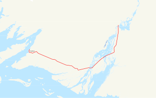
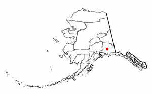
Copper Center is a census-designated place (CDP) on the Copper River in Valdez-Cordova Census Area, Alaska, United States. It is two hundred miles northeast of Anchorage. At the 2010 census the population was 328, down from 362 in 2000.

Cordova is a small town located near the mouth of the Copper River in the Valdez-Cordova Census Area, Alaska, United States, at the head of Orca Inlet on the east side of Prince William Sound. The population was 2,239 at the 2010 census, down from 2,454 in 2000. Cordova was named Puerto Cordova by Spanish explorer Salvador Fidalgo in 1790. No roads connect Cordova to other Alaskan towns, so a plane or ferry is required to travel there. In the Exxon Valdez oil spill of March 1989, an oil tanker ran aground northwest of Cordova, heavily damaging ecology and fishing. It was cleaned up shortly after, but there are lingering effects, such as a lowered population of some birds.

Gakona is a census-designated place (CDP) in the Valdez-Cordova Census Area in the U.S. state of Alaska. As of the 2010 census, the population of the CDP was 218, up from 215 in 2000.
Glennallen is a census-designated place (CDP) in the Valdez–Cordova Census Area in the Unorganized Borough of the U.S. state of Alaska. As of the 2010 census, the population of the CDP was 483, down from 554 in 2000.

McCarthy is a census-designated place (CDP) in Valdez-Cordova Census Area, Alaska, United States. The population was 28 at the 2010 census, down from 42 in 2000.
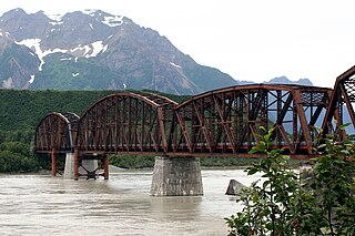
The Miles Glacier Bridge, also known as the Million Dollar Bridge, was built in the early 1900s across the Copper River fifty miles from Cordova in what is now the U.S. state of Alaska. It is a multiple-span Pennsylvania truss bridge which completed a 196-mile (315 km) railroad line for the Copper River and Northwestern Railway, built by J. P. Morgan and the Guggenheim family to haul copper from the old mining town of Kennicott, now located within the Wrangell–St. Elias National Park and Preserve, to the port of Cordova. It earned its nickname because of its $1.4 million cost, well recouped by the about $200 million worth of copper ore which was shipped as a result of its construction.

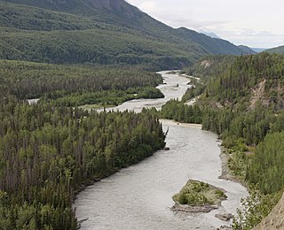
The Copper River or Ahtna River, Ahtna Athabascan ‘Atna’tuu, "river of the Ahtnas", Tlingit Eeḵhéeni, "river of copper", is a 290-mile (470 km) river in south-central Alaska in the United States. It drains a large region of the Wrangell Mountains and Chugach Mountains into the Gulf of Alaska. It is known for its extensive delta ecosystem, as well as for its prolific runs of wild salmon, which are among the most highly prized stocks in the world. The river is the tenth largest in the United States, as ranked by average discharge volume at its mouth.
The Matanuska River is a 75-mile (121 km) long stream in Southcentral Alaska, United States. The river drains a broad valley south of the Alaska Range eponymously known as the Matanuska Valley.

Wrangell–St. Elias National Park and Preserve is an American national park and preserve managed by the National Park Service in south central Alaska. The park and preserve were established in 1980 by the Alaska National Interest Lands Conservation Act. The protected areas are included in an International Biosphere Reserve and are part of the Kluane/Wrangell–St. Elias/Glacier Bay/Tatshenshini-Alsek UNESCO World Heritage Site. The park and preserve form the largest area managed by the National Park Service with a total of 13,175,799 acres, an expanse that could encapsulate a total of six Yellowstone National Parks. The park includes a large portion of the Saint Elias Mountains, which include most of the highest peaks in the United States and Canada, yet are within 10 miles (16 km) of tidewater, one of the highest reliefs in the world. Wrangell–St. Elias borders on Canada's Kluane National Park and Reserve to the east and approaches another American national park to the south, Glacier Bay. The chief distinction between park and preserve lands is that sport hunting is prohibited in the park and permitted in the preserve. In addition, 9,078,675 acres (3,674,009 ha) of the park and preserve are designated as the largest single wilderness in the United States.

The Copper River and Northwestern Railway (CR&NW) consisted of two rail lines, the Copper River line and the Northwestern line. Michael James Heney had secured the right-of-way up the Copper River in 1904. He started building the railway from Cordova, Alaska in 1906. The town of Cordova, Alaska, was actually named by Heney on March 13, 1906, based on the original name given by Salvador Fidalgo. Both these railroads were abandoned and little remains of them. Only a 0-4-0 locomotive, "Ole", located near Goose City on a siding of the Alaska Anthracite Railroad Company is the only equipment left. Many of the holdings of the CR&NW railroad including Ole were acquired for this railroad by Mr. Clark Davis and his partners in 1908 after a major storm destroyed the Katalla area facilities in 1907. The town of Cordova would like to move Ole to a memorial site in Cordova to celebrate its role in these railroads. Ole was declared eligible for the National Register of Historic Places in 1988.
The Gulkana River is a 60-mile (97 km) tributary of the Copper River in the U.S. state of Alaska. Beginning near the southeastern end of Summit Lake in the Alaska Range, the river flows generally south to meet the larger river 9 miles (14 km) northeast of Glennallen. The Richardson Highway and the Trans-Alaska Pipeline run north–south, nearby and roughly parallel to the Gulkana River. Slightly south of Summit Lake the river passes under the east–west Denali Highway near its junction with the Richardson Highway at Paxson.

Dease Lake is a small community located in the Cassiar Country of the Northern Interior of British Columbia, Canada. Located a few hours south of the Yukon border, it is located on Stewart–Cassiar Highway at the south end of the lake of the same name. Dease Lake is the last major centre before the Alaska Highway, and also the junction to Telegraph Creek and the Grand Canyon of the Stikine. Dease Lake Indian Reserve No. 9 is located nearby and is under the governance of the Tahltan First Nation band government.

The Tazlina River is a 30-mile (48 km) tributary of the Copper River in the U.S. state of Alaska. Draining Tazlina Lake, it flows generally east to meet the larger river 7 miles (11 km) southeast of Glennallen.
Denali Highway is a lightly traveled, mostly gravel highway in the U.S. state of Alaska. It leads from Paxson on the Richardson Highway to Cantwell on the Parks Highway. Opened in 1957, it was the first road access to Denali National Park. Since 1971, primary park access has been via the Parks Highway, which incorporated a section of the Denali Highway from Cantwell to the present-day park entrance. The Denali Highway is 135 miles (217 km) in length.
Yukon is one of Canada's three territories in the country's extreme northwest. Its history of human habitation dates back to the Ice Age, and the original inhabitants are believed to have arrived over 20,000 years ago by migrating over the land bridge from Asia. In the 18th century, Russian explorers began trade with the First Nations people along the Alaskan coast, beginning the establishment of trade relations throughout the region. The famous Klondike Gold Rush began after gold was discovered near Dawson City in 1896. As a result of the influx of people looking for gold, it was made a separate territory in 1898, split off from the Northwest Territories. The second major event in the Yukon's history is the construction of the Alaska Highway during the Second World War, for the transportation of war supplies. Eventually Whitehorse became the largest city in the Yukon, and then the capital in 1953.

The five principal meridians of Alaska are the Copper River meridian, Fairbanks meridian, Kateel River meridian, Seward meridian and Umiat meridian.
Copper River School District (CRSD) is a school district headquartered in Glennallen, Alaska. CRSD is known for being made up of several schools. The schools at times collaborate to achieve new educational opportunities. This is done primarily by VTC, or by transportation of students to either of the three schools.