
The federal city of Bonn is a city on the banks of the Rhine in the German state of North Rhine-Westphalia, with a population of over 300,000. About 24 km (15 mi) south-southeast of Cologne, Bonn is in the southernmost part of the Rhine-Ruhr region, Germany's largest metropolitan area, with over 11 million inhabitants. It is a university city and the birthplace of Ludwig van Beethoven. It was the capital city of the Electorate of Cologne from 1597 to 1794 and of West Germany from 1949 to 1990.

Uzbekistan is a country of Central Asia, located north of Turkmenistan and Afghanistan. With an area of 447,000 square kilometers, Uzbekistan stretches 1,425 km (885 mi) from west to east and 930 km (580 mi) from north to south. It borders Turkmenistan to the southwest, Kazakhstan to the north, and Tajikistan and Kyrgyzstan to the south and east.

The Jordan River, in the state of Utah, United States, is a river about 51 miles (82 km) long. Regulated by pumps at its headwaters at Utah Lake, it flows northward through the Salt Lake Valley and empties into the Great Salt Lake. Four of Utah's six largest cities border the river: Salt Lake City, West Valley City, West Jordan and Sandy. More than a million people live in the Jordan Subbasin, which is the part of the Jordan River watershed that lies within Salt Lake and Utah counties. During the Pleistocene, the area was part of Lake Bonneville.

The Hackensack River is a river, approximately 45 miles (72 km) long, in the U.S. states of New York and New Jersey, emptying into Newark Bay, a back chamber of New York Harbor. The watershed of the river includes part of the suburban area outside New York City just west of the lower Hudson River, which it roughly parallels, separated from it by the New Jersey Palisades. It also flows through and drains the New Jersey Meadowlands. The lower river, which is navigable as far as the city of Hackensack, is heavily industrialized and forms a commercial extension of Newark Bay. Once believed to be among the most polluted watercourses in the United States, it staged a modest revival by the late 2000s.

The Clean Water Act (CWA) is the primary federal law in the United States governing water pollution. Its objective is to restore and maintain the chemical, physical, and biological integrity of the nation's waters; recognizing the responsibilities of the states in addressing pollution and providing assistance to states to do so, including funding for publicly owned treatment works for the improvement of wastewater treatment; and maintaining the integrity of wetlands.

Onondaga Lake is a lake in Central New York, immediately northwest of and adjacent to Syracuse, New York. The southeastern end of the lake and the southwestern shore abut industrial areas and expressways; the northeastern shore and northwestern end border a series of parks and museums.
An outfall is the discharge point of a waste stream into a body of water; alternatively it may be the outlet of a river, drain or a sewer where it discharges into the sea, a lake or ocean.

The Cooks River, a semi-mature tide dominated drowned valley estuary, is a tributary of Botany Bay, located in south-eastern Sydney, New South Wales, Australia.

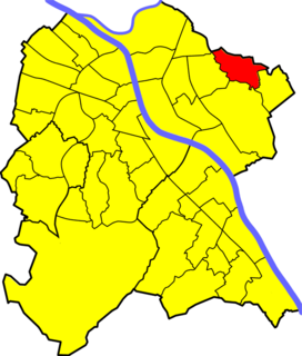
Jelezovac is an urban neighborhood of Belgrade, the capital of Serbia. It is located in the municipality of Rakovica. Though official city documents refer to the area as part of the Sunčani Breg-Jelezovac settlement, the neighborhood which developed in the western part of the Jelezovac area is known as Miljakovac III. Jelezovac remains as the name for the brook and its, still partially non-urbanized valley.
The Western Treatment Plant is a 110 km2 (42 sq mi) sewage treatment plant in Cocoroc, Victoria, Australia, 30 km (19 mi) west of Melbourne's central business district, on the coast of Port Phillip Bay. It was completed in 1897 by the Melbourne and Metropolitan Board of Works (MMBW), and is currently operated by Melbourne Water. The plant's land is bordered by the Werribee River to the east, the Princes Freeway to the north, and Avalon Airport to the west. It forms part of the Port Phillip Bay and Bellarine Peninsula Ramsar Site as a wetland of international importance. The Western Treatment Plant treats around 50% of Melbourne's sewage – about 485 ML per day - and generates almost 40,000 ML of recycled water a year.
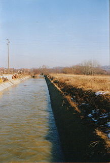
The Bolečica is a short river in north-central Serbia, a 12 km-long right tributary to the Danube. During its entire flow it runs through the suburban section of Belgrade and despite being short it flows through the three Belgrade's municipalities, next to the half dozen of suburbs of Belgrade with a total population of 35,000 and is a route to important roads.
Holzlar Is an enclosed settlement in Bonn's district Beuel, east of the Rhine and north of the Siebengebirge in Germany. Holzlar has a population of about 11,000 and consists out of the former villages Holzlar, Kohlkaul, Heidebergen, Roleber and Gielgen.

The East Rhine Railway is a major, double-track, electrified railway line, running along the right bank of the Rhine from Cologne to Wiesbaden. The 179-kilometer (111.2 mi)-long line forms two Deutsche Bahn routes. Route 465 extends from Cologne to Koblenz, via Troisdorf, Bonn-Beuel, Unkel, and Neuwied. From Koblenz, Route 466 extends to Wiesbaden, via Rüdesheim am Rhein. Together with the Taunus railway, the line is used by Stadt-Express line SE-10 of the Rhine-Main Transport Association, which runs from Frankfurt to Koblenz and Neuwied.
Castro Creek is a creek in Richmond, California, in the western part of the city adjacent to the Chevron Oil Refinery. Wildcat Creek drains into it directly and though other Wildcat Marsh tributaries into Castro Cove of San Pablo Bay. The creek drains from the drainage basin of the surrounding area and was once part of the channel that separated the island of Point Richmond with the mainland.
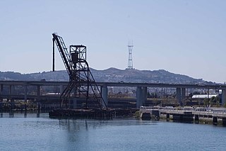
Islais Creek or Islais Creek Channel is a small creek in San Francisco, California. The name of the creek is derived from a Salinan Native American word "slay" or "islay", the name for the Prunus ilicifolia wild cherries. Around the time of the Gold Rush, the area became an industrial hub, and the condition of the creek worsened. After the devastating 1906 San Francisco earthquake, the city decided to reclaim the creek using earthquake debris, reducing the waterbody to its present size. Though much of Islais Creek has been converted to an underground culvert, remnants still exist today at both Glen Canyon Park and Third Street. Several community organizations are dedicated to preserve these remnants, as they are important wildlife habitats.

Mahanoy Creek is a 51.6-mile-long (83.0 km) tributary of the Susquehanna River in Northumberland and Schuylkill counties, Pennsylvania. There are at least 35 sources of acid mine drainage in the creek's watershed. Anthracite was mined in the upper part of the Mahanoy Creek watershed in the 19th and 20th centuries. Mahanoy Creek's tributaries include Schwaben Creek, Zerbe Run, Little Mahanoy Creek, Shenandoah Creek, and North Mahanoy Creek. Little Mahanoy Creek and Schwaben Creek are two streams in the watershed that are unaffected by acid mine drainage. Schwaben Creek has a higher number and diversity of fish species than the main stem.

South Fairmount is a neighborhood in Cincinnati, Ohio. It contains one of the highest concentrations of Section 8 housing in Hamilton County. The population was 2,368 at the 2010 census. South Fairmount lies just south of the North Fairmount neighborhood.
Tuscarora Creek is a 7.7-mile-long (12.4 km) tributary of the Monocacy River in Frederick County, Maryland, in the United States.
Allegheny County Sanitary Authority is a Municipal Authority in Allegheny County, Pennsylvania
The Steinlach is a river with a length of 26 km (16 mi) in Baden-Württemberg, Germany. It is a tributary to the Neckar.
