Related Research Articles

Albany County is a county in the state of New York, in the United States. Its northern border is formed by the Mohawk River, at its confluence with the Hudson River, which is on the east. As of the 2010 census, the population was 304,204. The county seat and largest city is Albany, the state capital of New York. As originally established by the English government in the colonial era, Albany County had an indefinite amount of land, but has had an area of 530 square miles (1,400 km2) since March 3, 1888. The county is named for the Duke of York and of Albany, who became James II of England.

Bethlehem is a town in Albany County, New York, United States. The town's population was 33,656 at the 2010 census. Bethlehem is located immediately to the south of the City of Albany. Bethlehem includes the following hamlets: Delmar, Elsmere, Glenmont, North Bethlehem, Selkirk, Slingerlands, and South Bethlehem. U.S. Route 9W passes through the town. The town is named after the biblical Bethlehem.

Voorheesville is a village within the town of New Scotland in Albany County, New York, United States. It is a suburb of Albany and part of the city's historic metropolitan area. The population was 2,789 at the 2010 census. The village is named after a railroad attorney, Alonzo B. Voorhees.
New York State Route 32 (NY 32) is a north–south state highway that extends for 176.73 miles (284.42 km) through the Hudson Valley and Capital District regions of the U.S. state of New York. It is a two-lane surface road for nearly its entire length, with few divided and no limited-access sections. From Harriman to Albany, it is closely parallel to Interstate 87 (I-87) and U.S. Route 9W (US 9W), overlapping with the latter in several places.
The Delaware and Hudson Railway (D&H) is a railroad that operates in the Northeastern United States. In 1991, after more than 150 years as an independent railroad, the D&H was purchased by the Canadian Pacific Railway (CP). CP operates D&H under its subsidiary Soo Line Corporation which also operates Soo Line Railroad.

The Long Path is a 357-mile (575 km) long-distance hiking trail beginning at the George Washington Bridge in Fort Lee, New Jersey and ending at Altamont, New York, in the Albany area. While not yet a continuous trail, relying on road walks in some areas, it nevertheless takes in many of the popular hiking attractions west of the Hudson River, such as the New Jersey Palisades, Harriman State Park, the Shawangunk Ridge and the Catskill Mountains. It offers hikers a diversity of environments to pass through, from suburbia and sea-level salt marshes along the Hudson to wilderness and boreal forest on Catskill summits 4,000 feet (1,220 m) in elevation.

John Boyd Thacher State Park is a state park located 15 miles (24 km) southwest of Albany, New York, near Voorheesville, in Albany County on State Route 157. Located mostly atop the Helderberg Escarpment, the park has several hiking trails that offer panoramic views of the Green Mountains in Vermont and the Taconic Mountains of the Hudson Valley.

The Mount Vernon Trail (MVT) is a 17 miles (27 km) long shared use path that travels along the George Washington Memorial Parkway in Northern Virginia between Rosslyn and George Washington's home at Mount Vernon. The trail connects the easternmost portions of Arlington County, the City of Alexandria, and Fairfax County, and travels mostly on dedicated trail with a small portion on city streets. As part of U.S. Bike Route 1, the MVT opened in April 1972 as a gravel path and was subsequently expanded and paved.

Area codes 518 and 838 are telephone area codes serving the northeasternmost part of the "upstate" part of New York in the United States. 518 was established as one of the original area codes during 1947. 838 was added as an overlay during 2017. It covers 24 counties and 1,200 ZIP Codes. There are 493 landline and 100 wireless exchanges served by 47 carriers. It is the largest area code in size in New York, extending from the eastern Mohawk Valley to the Vermont border, and from the Canada–US border to south of Albany. The bulk of the area code's population is in the Capital District. Other cities in the area code are Glens Falls, Plattsburgh, and Saratoga Springs.

The Capital Crescent Trail (CCT) is a 7.04-mile (11.33 km) long, shared-use rail trail that runs from Georgetown in Washington, D.C., to Bethesda, Maryland. An extension of the trail from Bethesda to Silver Spring, along a route formerly known as the Georgetown Branch Trail is currently being constructed as part of the Purple Line light rail project.
Crescent Station is a hamlet of the town of Colonie in Albany County, New York that straddles US Route 9.
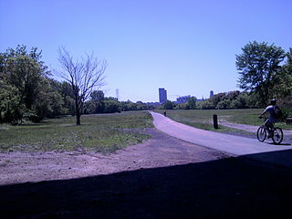
The Mohawk-Hudson Bike-Hike Trail (MHBHT) is an 86-mile (138 km) trail in New York's Mohawk Valley and Capital District regions. It is also the easternmost segment of the Erie Canalway Trail, as well as a portion of the Empire State Trail.
The Anacostia Tributary Trail System (ATTS) is a unified and signed system of stream valley trails joining trails along the Anacostia tributaries of Northwest Branch, Northeast Branch, Indian Creek and Paint Branch with a trail along the Anacostia River, set aside and maintained by the Maryland-National Capital Park and Planning Commission (M-NCPPC) in the Maryland suburbs of Washington, D.C.
Clarksville is a hamlet in the town of New Scotland, Albany County, New York. It is situated along Delaware Turnpike in the southern part of the town at the foot of the Helderberg Escarpment. It is the site of the Clarksville Cave and has an annual Clarksville Heritage Day and Car Show. It is in the Onesquethaw Volunteer Fire Company fire protection district.
Van Schaick Island is an island in the city of Cohoes, New York. Van Schaick is a part of the delta of the Mohawk River at its mouth with the Hudson River. The island has been referred to by numerous names including Quehemesicos, Long, Anthony's, Isle of Cohoes, and Cohoes Island. The island was home to US Revolutionary War fortifications in the 18th century, and to an important shipyard in the 20th century. The shipyard and the extreme northern end of the island is part of the Peebles Island State Park, and the only vehicular entrance to the state park is on the island.

The Walden–Wallkill Rail Trail, also known as the Jesse McHugh Rail Trail, is a 3.22-mile (5.18 km) rail trail between the village of Walden, New York and the neighboring hamlet of Wallkill. The two communities are located in Orange and Ulster counties, respectively, in upstate New York.
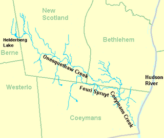
Onesquethaw Creek is a 14.5-mile-long (23.3 km) creek in Albany County, New York. It is a tributary of the Hudson River. It rises in the town of New Scotland, to the west of the hamlet of New Salem, in the Helderberg Mountains, and flows to Coeymans Creek in the town of Bethlehem, southwest of Delmar.

The Empire State Trail is a 750-mile (1,210 km) multi-use trail that was proposed by Governor Andrew Cuomo in January 2017. The trail would run from Manhattan north to the northern tip of Lake Champlain and also from Buffalo to Albany. The trail will join existing trail segments, which will retain their existing identity but will be co-signed as a segment of the statewide Empire State Trail. The trail will also link to other regional bicycling and hiking trails such as the Appalachian Trail, the Adirondack and Catskill Parks, the Great Lakes Seaway Trail, the Genesee Valley Greenway, and others. A segment near its southernmost part, on the Hudson River Greenway in Manhattan, is concurrent with the East Coast Greenway. The trail will be used for hiking, biking, snowshoeing, cross-country skiing and in some areas snowmobiling.
References
- ↑ "Rail Trail". Albany, New York: Albany County. 2019.
- ↑ "Capital District Multi-Use Trail User Counts" (PDF). Albany, New York: Capital District Transportation Committee. 2017.