
The province of Grosseto is a province in the Tuscany region of Italy. Its capital is the city of Grosseto. As of 2013 the province had a total population of 225,098 people.

The Maputo River, also called Great Usutu River, Lusutfu River, or Suthu River, is a river in South Africa, Eswatini, and Mozambique. The name Suthu refers to Basotho people who lived near the source of the river, but were attacked and displaced by Swazis. It is also said to mean 'dark brown', a description of the river's muddy water.

River Walkham is a river whose source is on Dartmoor, Devon, England.

The Sauk River is a tributary of the Skagit River, approximately 45 miles (72 km) long, in northwestern Washington in the United States. It drains an area of the high Cascade Range in the watershed of Puget Sound north of Seattle. The river is a popular destination for fly fishing. It is a National Wild and Scenic River.

Middle Park is a high basin in the Rocky Mountains of north-central Colorado in the United States. It is located in Grand County, on the southwest slope of Rocky Mountain National Park, approximately 50 miles (80 km) west of Boulder.

The Harts River is a northern tributary of the Vaal River, which in turn is the largest tributary of the Orange River. Its source is in the North West Province, but the greater part of its basin is located in the Northern Cape Province, which it enters a few kilometers downstream from the Taung Dam.
Singletons Mill is a suburb of Sydney, in the state of New South Wales, Australia. It is located in the Hornsby Shire local government area.

Fulham Railway Bridge crosses the River Thames in London. It is very close to Putney Bridge, and carries the London Underground District line between Putney Bridge station on the North, and East Putney station on the South. Fulham Railway Bridge can also be crossed on foot, on the downstream (east) side.

The Conecuh River and Escambia River are a single 258-mile-long (415 km) river in the southern United States, which flows from Alabama through Florida into the Gulf of Mexico.

Mattinata is a seaside resort town and comune (municipality) in the province of Foggia, Apulia, southern Italy.

Monte Argentario is a comune (municipality) and a peninsula belonging to the Province of Grosseto in the Italian region Tuscany, located about 150 kilometres (93 mi) south of Florence and about 35 kilometres (22 mi) south of Grosseto. The peninsula is connected with the mainland by three spits of land which form two lagoons, the Laguna di Ponente on the west side and the Laguna di Levante on the east side of the middle dam. The two main villages on Monte Argentario are Porto Santo Stefano, chief town, facing north, and Porto Ercole facing south.
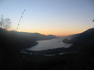
The Riñihue Lake is a lake of glacial origin in eastern Valdivia Province, southern Chile. It is surrounded by several mountains. The eastern side receives the waters of the Panguipulli Lake by the Enco River, its main contributor. It is the last of the Seven Lakes chain. In the west it is cut into two arms by the Tralcán Mount, and on the east side lies the Mocho-Choshuenco volcano. In the south the lake is bounded by the Cerros de Quimán mountains.

The Passumpsic River is a 22.7-mile-long (36.5 km) tributary of the Connecticut River, in Vermont. Though primarily a Caledonia County river, it is the only river to flow through all three counties of the Northeast Kingdom.

Nomexy is a commune in the Vosges department in Grand Est in northeastern France.

The Kamnik Bistrica is an Alpine river in northern Slovenia, a left tributary of the Sava River. It springs from the Kamnik Alps near the border with Austria. It is 33 km (21 mi) long. The Kamnik Bistrica flows through the town of Kamnik, where it is fed by the Nevljica River. It flows into the Sava south of Videm, about 10 km east of Ljubljana.
Ootischenia is south of Castlegar on the east side of the Columbia River in the West Kootenay region of southern British Columbia.

When the Second Boer War broke out on 11 October 1899, the Boers had a numeric superiority within Southern Africa. They quickly invaded the British territory and laid siege to Ladysmith, Kimberley and Mafeking. Britain meanwhile transported thousands of troops both from the United Kingdom itself and from elsewhere in the Empire and by the time the siege of Ladysmith had been lifted, had a huge numeric superiority.

The Fish River is a 69.9-mile-long (112.5 km) river in northern Maine in the United States. It is a tributary of the Saint John River, which flows to the Bay of Fundy in New Brunswick, Canada.
Old Latium is a region of the Apennine Peninsula bounded to the north by the Tiber River, to the east by the central Apennine Mountains, to the west by the Mediterranean Sea and to the south by Monte Circeo. It was the territory of the Latins, an Italic tribe which included the early inhabitants of the city of Rome. Later it was also settled by various Italic tribes such as the Rutulians, Volscians, Aequi, and Hernici. The region was referred to as "old" to distinguish it from the expanded region, Latium, that included the region to the south of Old Latium, between Monte Circeo and the river Garigliano – the so-called Latium adiectum. It corresponded to the central part of the modern administrative region of Lazio, Italy, and it covered an area measuring of roughly 50 Roman miles. It was calculated by Mommsen that the region's area was about 1860 square kilometres.
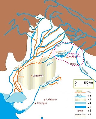
The Tangri River, also called the Dangri River, which originates in the Shivalik Hills, is a tributary of the Ghaggar River in the Haryana state of India.

