The province of Grosseto is a province in the Tuscany region of Italy. Its capital is the city of Grosseto. As of 2013 the province had a total population of 225,098 people.

Fabriano is a town and comune of Ancona province in the Italian region of the Marche, at 325 metres (1,066 ft) above sea level. It lies in the Esino valley 44 kilometres (27 mi) upstream and southwest of Jesi; and 15 kilometres (9 mi) east-northeast of Fossato di Vico and 36 kilometres (22 mi) east of Gubbio. Its location on the main highway and rail line from Umbria to the Adriatic make it a mid-sized regional center in the Apennines. Fabriano is the headquarters of the giant appliance maker Indesit.
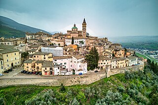
Trevi is an ancient town and comune (municipality) in Umbria, Italy, on the lower flank of Mount Serano overlooking the wide plain of the Clitunno river system. Located in the Province of Perugia, it is 10 km (6 mi) SSE of Foligno and 20 km (12 mi) north of Spoleto. It is one of I Borghi più belli d'Italia.

Saturnia is a spa town in Tuscany in north-central Italy that has been inhabited since ancient times. It is a frazione of the comune of Manciano, in the province of Grosseto. Famous for the spa which gives it its name, its population is 280.

Poggio a Caiano is a town and comune in the province of Prato, Tuscany region Italy. The town, birthplace of Philip Mazzei, lies 9 kilometres (6 mi) south of the provincial capital of Prato.
Castel San Pietro Terme is a comune (municipality) in the Metropolitan City of Bologna, in the Italian region of Emilia-Romagna, with about 21,000 inhabitants. It is located along the Roman Via Emilia, at the foot of the Tuscan-Emilian Apennines.

Pescaglia is a comune (municipality) in the Province of Lucca in the Italian region Tuscany, located about 70 kilometres (43 mi) northwest of Florence and about 15 kilometres (9 mi) northwest of Lucca.

Signa is a comune (municipality) in the Metropolitan City of Florence in the Italian region Tuscany, located about 12 kilometres (7 mi) west of Florence.

Suvereto is a comune (municipality) in the Province of Livorno in the Italian region Tuscany, located about 90 kilometres southwest of Florence and about 60 kilometres (37 mi) southeast of Livorno. It is one of I Borghi più belli d'Italia.

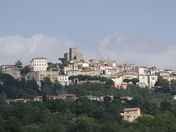
Roccalbegna is a comune (municipality) in the Province of Grosseto in the Italian region Tuscany, located about 110 kilometres (68 mi) south of Florence and about 35 kilometres (22 mi) east of Grosseto.
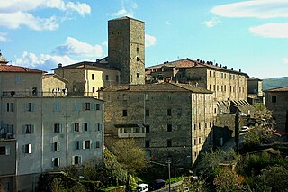
Santa Fiora is a comune (municipality) in the province of Grosseto, in the Italian region of Tuscany, located about 110 kilometres southeast of Florence and about 40 km (25 mi) east of Grosseto. Santa Fiora borders the following municipalities: Abbadia San Salvatore, Arcidosso, Castel del Piano, Castell'Azzara, Piancastagnaio, Roccalbegna, and Semproniano. It is one of I Borghi più belli d'Italia.

Semproniano is a comune (municipality) in the Province of Grosseto in the Italian region of Tuscany, about 120 kilometres (75 mi) south of Florence and about 35 kilometres (22 mi) east of Grosseto.

Poggio Mirteto is a comune (municipality) is situated in the Tiber Valley area of the region of Latium, Italy. Administratively Poggio Mirteto is in the province of Rieti and geographically this municipality is about 45 kilometres (28 mi) northeast of Rome and about 20 kilometres (12 mi) southwest of Rieti.

Carmignano is a comune (municipality) in the province of Prato, part of the Italian region Tuscany. It is located about 20 kilometres (12 mi) west of Florence and about 10 kilometres (6 mi) southwest of Prato. It is the centre of the wine region of the same name.

Marsiliana, known also as Marsiliana d'Albegna, is a village in Tuscany, central Italy, administratively a frazione of the comune of Manciano, province of Grosseto. At the time of the 2001 census its population amounted to 246.

Montemerano is a village in Tuscany, central Italy, administratively a frazione of the comune of Manciano, province of Grosseto. At the time of the 2001 census its population amounted to 438. It is one of I Borghi più belli d'Italia.
Poderi di Montemerano is a village in Tuscany, central Italy, administratively a frazione of the comune of Manciano, province of Grosseto. At the time of the 2001 census its population amounted to 84.
Poggio Capanne is a village in Tuscany, central Italy, administratively a frazione of the comune of Manciano, province of Grosseto. At the time of the 2001 census its population amounted to 101.

Poggio Murella is a village in Tuscany, central Italy, administratively a frazione of the comune of Manciano, province of Grosseto. At the time of the 2011 census its population amounted to 287.

San Martino sul Fiora is a village in Tuscany, central Italy, administratively a frazione of the comune of Manciano, province of Grosseto. At the time of the 2001 census its population amounted to 224.