
The London Borough of Hackney is a London borough in Inner London, England. The historical and administrative heart of Hackney is Mare Street, which lies 5 miles (8 km) north-east of Charing Cross. The borough is named after Hackney, its principal district. Southern and eastern parts of the borough are popularly regarded as being part of east London, with the northwest belonging to north London. Its population is 281,120 inhabitants.

The New River is an artificial waterway in England, opened in 1613 to supply London with fresh drinking water taken from Chadwell and Amwell Springs near Ware in Hertfordshire, and later the River Lea and other sources. Originally conceived by Edmund Colthurst and completed by Hugh Myddelton, it was operated by the New River Company for nearly 300 years until London's water supply was taken over by the Metropolitan Water Board in 1904.

The Metropolitan Borough of Shoreditch was a metropolitan borough of the County of London between 1899 and 1965, when it was merged with the Metropolitan Borough of Stoke Newington and the Metropolitan Borough of Hackney to form the London Borough of Hackney.

The Wenlock Arms is a public house in Hoxton, in London's East End, which began trading in 1787. The pub is located halfway between Old Street and Angel, just off the City Road and the City Road Basin and Wenlock Basin on the Regent's Canal. The pub has won awards for the quality and range of its cask ales.

Queen Square is a garden square in the Bloomsbury district of central London. Many of its buildings are associated with medicine, particularly neurology.

Lambeth Walk is a street in Lambeth, London, England, off Lambeth Road. It was at the heart of a working-class residential area and there was a street market.

St Leonard's, Shoreditch, is the ancient parish church of Shoreditch, often known simply as Shoreditch Church. It is located at the intersection of Shoreditch High Street with Hackney Road, within the London Borough of Hackney in East London. The current building dates from about 1740 and is Grade I listed. The church is mentioned in the line ""When I grow rich", say the bells of Shoreditch" from the nursery rhyme Oranges and Lemons.

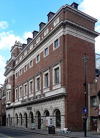
Poplar Baths on the East India Dock Road in Poplar, London is a former public bath house and Grade II listed building that was constructed in 1933 and closed to the public in 1988. The Baths are adjacent to All Saints DLR station. A campaign to restore the baths won the support of Tower Hamlets Council in 2010 and the construction company Guildmore was appointed to complete the works to create a new leisure centre incorporating a swimming pool, gymnasium and affordable housing on adjacent land. The site reopened in July 2016.

Shoreditch High Street is the old main street of Shoreditch, London. It is part of the A10 road and connects Norton Folgate to the south with Kingsland Road to the north. It constitutes a segment of the Roman Ermine Street, which ran directly north from London to Lincoln and York. The parish church of St Leonard's, Shoreditch is situated at the north-east end of the road, at the crossroads where it meets with Hackney Road.
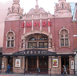
Hackney Empire is a theatre on Mare Street, in Hackney in the London Borough of Hackney. Originally designed by Frank Matcham it was built in 1901 as a music hall, and expanded in 2001. Described by The Guardian as "the most beautiful theatre in London" it is an Arts Council England National Portfolio Organisation.

The Britannia Theatre (1841–1900) was located at 115/117 High Street, Hoxton, London. The theatre was badly damaged by a fire in 1900, forcing the sale of the lease. The site was reused as a Gaumont cinema from 1913 to 1940, before being demolished to make room for a more modern cinema which was never built. Housing has now been built on the site, which is marked by a London Borough of Hackney historic plaque.

Duke Street Church is a conservative evangelical church in Duke Street, Richmond, South West London, with a historical Baptist tradition. It is affiliated with the Fellowship of Independent Evangelical Churches (FIEC), the Evangelical Alliance and the Affinity and South East Gospel Partnership.
The Marshall Street Baths in Westminster, London, were built in 1850. They were closed for refurbishment in 1997 and reopened on 27 July 2010 as a modernised leisure centre. The building is noted for its architecture and is Grade II listed.

The York Hall, officially known as York Hall Leisure Centre, is a multi-purpose indoor arena and leisure complex in Bethnal Green, London, and is situated on Old Ford Road. The building opened in 1929 with a capacity of 1,200 and is now an international boxing venue. The main hall also hosts concerts and other live events and other facilities also include a local gymnasium and a swimming pool.

Oasis Sports Centre is a leisure centre in Holborn, London, operated by Greenwich Leisure Limited on behalf of the London Borough of Camden.
Arthur Ashpitel (1807–1869) was an English architect. He trained under his father, William Hurst Ashpitel before setting up his own practice in 1842, and working in partnership with John Whichcord Jr. between 1850 and 1855. Ashpitel's works include the churches of St Barnabas, Homerton and St John the Evangelist, Blackheath.

St Mary, Haggerston, was an Anglican parish church built to the designs of John Nash in 1827, in what is now the London Borough of Hackney. Built in the Gothic style of its time, it had an elaborate west front with a disproportionately tall tower. The rest of the church was, in comparison, rather plain. It was altered later in the 19th century by James Brooks as the first initiative of the Haggerston Church Scheme, and destroyed by bombs during the Second World War. The site is now a children's playground west of Haggerston Park, between Thurtle Road and Queensbridge Road.
The Gravel Pit Chapel was established in 1715–1716 in Hackney, then just outside London, for a Nonconformist congregation, which by the early 19th century began to identify itself as Unitarian. In 1809 the congregation moved to the New Gravel Pit Chapel nearby, while its old premises were taken over by Congregationalists. The New Gravel Pit Chapel was closed and demolished in1969.

Mare Street is a street in the London Borough of Hackney. It has existed since the 15th century, when it was one of the first roads at the centre of the parish. It was then known as Merestret. The word mere was either the Old English mǣre meaning a boundary — referring to the boundary with the parish of Stepney — or mere, a large pond which was fed by Hackney Brook.
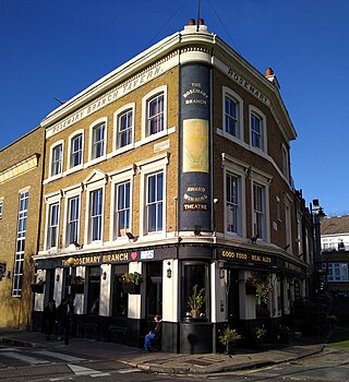
The Rosemary Branch Theatre is a pub theatre located in Islington, London. It has been operating for 35 years. It was originally known as the Rosemary Theatre in 1986. In late spring of 1986 the upstairs of the Rosemary Branch was converted into a theatre. The same space has always been used but the technical area was originally between the stage left entrance corridor and the central aisle just adjacent to the entrance. The first production, starring Mark Heath and directed by James Marcus was "Napoleon Noir", describing the heroic feats of Toussaint L'Ouverture, who in the late 18th century fought to abolish slavery in Saint-Domingue. The next play was the well-received dark comedy "Curtains" by Tom Mallin. This had its premiere at the Edinburgh Festival in 1970 with Nigel Hawthorne as one of a couple made murderous by the introduction of a third party. Lastly, before the Theatre's initial season closed, Cavada Humphrey presented her autobiographical solo performance "Walking Papers"; a powerful and focused work. The building was previously a Victorian music hall.
