
Aldbourne Heritage Centre is a local museum in North-East Wiltshire, England, next to The Crown Inn in the centre of Aldbourne.
Aldbourne Heritage Centre is a local museum in North-East Wiltshire, England, next to The Crown Inn in the centre of Aldbourne.
It opened in August 2014, presenting objects and displays which provide insights into the history of Aldbourne from prehistoric times to the present day. It is managed by the Aldbourne Community Heritage Group (ACHG), which also organises talks and events on topics related to local history.
The Heritage Centre is a member of the South Western Federation of Museums and Art Galleries. In 2015 it was a partner in Wiltshire Museum's project "Wiltshire's Story in 100 Objects", [1] a touring exhibition celebrating the rich history of the county, having provided an 18th-century crotal bell cast in Aldbourne as one of the 100 objects.
The Centre presents a changing set of displays, covering a diverse range of subjects, such as:
Objects on display include prehistoric flints used as tools and recovered from local Bronze Age barrows; two replicas of the Aldbourne Cup, one in its current, aged and reconstructed state, and a second in its original state (the original is on display at the British Museum); copies of mediaeval and Tudor documents relating to the exercise of manorial rights by the Duchy of Lancaster and the judgments of manorial courts; a range of hand-bells and crotal bells made in Aldbourne by the Corr and Wells families (and others); a 19th-century fireman’s helmet; items of Victorian (and earlier) agricultural hand tools; items relating to the wartime residence of US military personnel in the village; and thousands of photographs of life in Aldbourne from the mid-Victorian period to the present day.
The centre is open on Saturdays, Sundays and Bank Holidays throughout the summer. Visits at other times can be arranged by appointment.

Avebury is a village and civil parish in Wiltshire, England. The village is about 5.5 miles (9 km) west of Marlborough and 8 miles (13 km) northeast of Devizes. Much of the village is encircled by the prehistoric monument complex also known as Avebury. The parish also includes the small villages of Avebury Trusloe and Beckhampton, and the hamlet of West Kennett.

Tidworth is a garrison town and civil parish in south-east Wiltshire, England, on the eastern edge of Salisbury Plain. Lying on both sides of the A338 about 3+1⁄2 miles (5.6 km) north of the A303 primary route, the town is approximately 8 miles (13 km) west of Andover, 12 miles (19 km) south of Marlborough, and 13 miles (21 km) north by north-east of Salisbury. The population of the parish at the 2011 census was approximately 10,600.

Chute is a civil parish in east Wiltshire, England, on the border with Hampshire. It includes the main village of Upper Chute and the smaller settlements of Lower Chute, Chute Standen, Chute Cadley and Mount Cowdown. The settlements are sometimes known collectively as "The Chutes". The nearest town is Andover, Hampshire, about 6 miles (10 km) to the southeast.

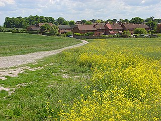
Aldbourne is a village and civil parish about 6 miles (10 km) north-east of Marlborough, Wiltshire, England, in a valley on the south slope of the Lambourn Downs – part of the North Wessex Downs Area of Outstanding Natural Beauty. From here an unnamed winterbourne flows south to join the River Kennet 4 miles (6 km) away near Ramsbury. The 2011 Census recorded the parish population as 1,833. The parish includes the hamlets of Upper Upham and Woodsend and part of the hamlet of Preston, which straddles the boundary with Ramsbury. The village of Snap became deserted in the early 20th century.
All Cannings is a village and civil parish in the Vale of Pewsey in the English county of Wiltshire, about 4 miles (6 km) east of Devizes. The parish includes the nearby smaller settlement of Allington.

Alton is a civil parish in Wiltshire, England. The parish includes the adjacent villages of Alton Barnes and Alton Priors, and the nearby hamlet of Honeystreet on the Kennet and Avon Canal. It lies in the Vale of Pewsey about 6 miles (10 km) east of Devizes.

Wiltshire is a historic county located in the South West England region. Wiltshire is landlocked and is in the east of the region.

Winterslow is a civil parish with a population of around 2,000, about 6 miles (10 km) northeast of Salisbury in Wiltshire, England, and lying south of the A30 London Road. It is sited on the Roman road between Old Sarum and Winchester.

Tollard Royal is a village and civil parish on Cranborne Chase, Wiltshire, England. The parish is on Wiltshire's southern boundary with Dorset and the village is 6 miles (10 km) southeast of the Dorset town of Shaftesbury, on the B3081 road between Shaftesbury and Sixpenny Handley.

Heytesbury is a village and a civil parish in Wiltshire, England. The village lies on the north bank of the Wylye, about 3+1⁄2 miles (5.6 km) southeast of the town of Warminster.

Alvediston is a small village and civil parish in Wiltshire, England, about 7 miles (11 km) east of Shaftesbury and 11 miles (18 km) southwest of Salisbury. The area is the source of the River Ebble and is within the Cranborne Chase and West Wiltshire Downs Area of Outstanding Natural Beauty.

Colerne is a village and civil parish in north Wiltshire, England. The village is about 3.5 miles (6 km) west of the town of Corsham and 7 miles (11 km) northeast of the city of Bath. It has an elevated and exposed position, 545 feet (166 m) above sea level, and overlooks the Box valley to the south.

Upton Lovell is a village and civil parish in Wiltshire, England. It lies on the A36, in the Wylye valley about 5 miles (8.0 km) southeast of Warminster. The parish is on the left (northeast) bank of the river, and stretches for over two miles northeast onto Salisbury Plain.

Milton Lilbourne is a village and civil parish in the county of Wiltshire, England, in the Vale of Pewsey between Pewsey and Burbage. It is largely a mixed residential area centred on the Manor. The nearest town is Marlborough, 5.5 miles (8.9 km) to the north.

Bolton Museum is a public museum, aquarium and art gallery in the town of Bolton, England, owned by Bolton Metropolitan Borough Council. The museum is housed within the grade II listed Le Mans Crescent near Bolton Town Hall and shares its main entrance with the central library in a purpose-built civic centre. The building has good accessibility.


Tilshead is a village and civil parish in the county of Wiltshire in Southern England, about 9 miles (14 km) northwest of the town of Amesbury. It is close to the geographical centre of Salisbury Plain, on the A360 road approximately midway between the villages of Shrewton and Market Lavington, and is near the source of the River Till. Its population in 2011 was 358, down from a peak of 989 inhabitants in 1951.

Crotal bells are various types of small bells or rattles. They were produced in various pre-Columbian cultures. In Europe they were probably made from before the early Middle Ages; though many founders cast bells of this type, the Robert Wells bell foundry of Aldbourne, Wiltshire, produced the largest range. The first medieval designs came in two separate halves into which a metal pea was introduced and the two halves were then soldered or crimped together. Somewhere around 1400 they were cast in a single piece with a ball of metal inside.

Kingston Deverill is a village and civil parish in Wiltshire, England. Its nearest towns are Mere, about 3+1⁄2 miles (6 km) to the southwest, and Warminster, about 5 miles (8 km) to the northeast. The parish and its demographic figures include the village of Monkton Deverill.

West Knoyle is a small village and civil parish in southwest Wiltshire, England, close to the southern edge of Salisbury Plain. The village is about 2.5 miles (4 km) east of Mere and 8 miles (13 km) south of Warminster. The A303 trunk road passes about 0.75 miles (1,210 m) north of the village.