East Hill-Meridian is a former census-designated place (CDP) in King County, Washington, United States. The population was 29,878 at the 2010 census. The majority of the census area is now within the limits of Kent and Renton.

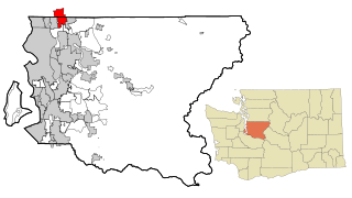
Inglewood-Finn Hill was a census-designated place (CDP) in King County, Washington, United States. The population was 22,707 at the 2010 census. The community was largely annexed into neighboring Kirkland in 2011.

Alderwood Manor is a census-designated place (CDP) in Snohomish County, Washington, United States. The population was 8,442 at the 2010 census. Prior to the 2000 census, Alderwood Manor was counted as part of the Alderwood Manor-Bothell North CDP. Some of Alderwood Manor lies in the Lynnwood MUGA meaning some of the area of Alderwood Manor uses a Lynnwood postal address. some uses a Bothell postal address, and some uses a Brier postal address.

Machias is a census-designated place (CDP) in Snohomish County, Washington, United States. The population was 1,178 at the 2010 census.

Maltby is a census-designated place (CDP) in Snohomish County, Washington, United States. The population was 10,830 at the 2010 census.

North Creek is an unincorporated community, formerly a census-designated place (CDP), in Snohomish County, Washington. Part of the community lies within the city limits of Bothell. Based on per capita income, one of the more reliable measures of affluence, Bothell ranks 68th of 614 areas in the state of Washington to be ranked.
Silver Firs is a census-designated place (CDP) in Snohomish County, Washington, United States. The population was 20,891 at the 2010 census. It lies northeast of the city of Mill Creek. Silver Firs is one of two CDPs that were created out of the former Seattle Hill-Silver Firs CDP in 2010, the other being Eastmont.

Marietta-Alderwood is a census-designated place (CDP) in Whatcom County, Washington, United States. The population was 3,906 at the 2010 census.

The University of Washington Bothell is a four-year university, offering undergraduate and graduate programs in northeast King County, as one of the three campuses of the public University of Washington system. The campus was established in 1990. UW Bothell is the largest branch campus in the state and the fastest growing four-year university in the state of Washington. In 2014 and 2015, Money Magazine ranked UW Bothell as the best university in Washington state in terms of value and quality. In the same study, UW Bothell ranked 10th nationally among public universities and 36th overall.

Fobes Hill is an unincorporated community and a census-designated place (CDP) in Snohomish County, Washington, United States. The population was 2,418 at the 2010 census. Fobes Hill is a middle class residential community located along Fobes Road, northwest of the city of Snohomish.
Victory Heights is a neighborhood in the Lake City district of Seattle, Washington. It was named after the Victory Highway, which formed the eastern border of the area. The highway was originally called the Gerhart Erickson Road, the namesake of which was Gerhart Erickson, who sponsored the Good Roads legislation in 1903. The road was then renamed Bothell Road, changed to Victory Highway in 1924, before returning to Bothell Road; it is now called Lake City Way NE. The neighborhood was annexed to the city of Seattle in 1954.
Alderton is a census-designated place (CDP) in Pierce County, Washington, United States. The population was 2,893 at the 2010 census. The community is located in the Puyallup River Valley between the cities of Sumner and Orting.
Boulevard Park is a census-designated place (CDP) in King County, Washington, United States. The population was 5,287 at the 2010 census. Boulevard Park was part of the Riverton-Boulevard Park CDP, until it was split for the 2010 census into Riverton and Boulevard Park.
Lake Holm is a census-designated place (CDP) in King County, Washington, United States. The population was 3,221 at the 2010 census.
Shadow Lake is a census-designated place (CDP) in King County, Washington, United States. The population was 2,262 at the 2010 census.
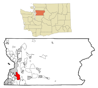
Bothell East is a census-designated place (CDP) in Snohomish County, Washington, United States. The population was 8,018 at the 2010 census. Bothell East is one of several CDPs that were created out of the former North Creek CDP in 2010.
Bothell West is a census-designated place (CDP) in Snohomish County, Washington, United States. The population was 16,607 at the 2010 census. Bothell West is one of several CDPs that were created out of the former North Creek CDP in 2010.
Bunk Foss is a census-designated place (CDP) in Snohomish County, Washington, United States. The population was 3,570 at the 2010 census. Bunk Foss was created out of the former West Lake Stevens CDP in 2010.
Cavalero is a census-designated place (CDP) in Snohomish County, Washington, United States. The population was 4,660 at the 2010 census. Cavalero was created out of the former West Lake Stevens CDP in 2010.
Eastmont is a census-designated place (CDP) in Snohomish County, Washington, United States. The population was 20,101 at the 2010 census. Eastmont is one of two CDPs that were created out of the former Seattle Hill-Silver Firs CDP in 2010, the other being Silver Firs. Eastmont is the location of Community Transit's Eastmont Park & Ride, which is serviced by Sound Transit Express route 513.