
Galveston County is a county in the U.S. state of Texas, located along the Gulf Coast adjacent to Galveston Bay. As of the 2010 U.S. Decennial Census, the population was 291,309. The county seat is the City of Galveston, founded the following year of 1839, located on Galveston Island; the most populous municipality in the county is League City, a suburb of Houston at the northern end of the county, which surpassed Galveston in population during the early 2000s. The county was founded in 1838.

La Porte is a city in Harris County, Texas, United States, within the Bay Area of the Houston–Sugar Land–Baytown metropolitan area. As of the 2010 census, the city population was 33,800. La Porte is the fourth-largest incorporated city in Harris County.
Morgan's Point is a city in Harris County, Texas, United States, located on the shores of Galveston Bay at the inlet to the Houston Ship Channel, near La Porte and Pasadena. As of the 2010 census, it had a population of 339. It earned fame in Texas' early history for being the home of the legendary Emily West (Morgan), known as "The Yellow Rose of Texas". It later became a Houston-area resort community for the wealthy in the early 20th century. Today, thanks to the construction of the Barbours Cut shipping terminal, it is at the center of one the area's most important shipping hubs.

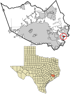
League City is a city in Galveston County, Texas, within the Greater Houston metropolitan area. As of the 2010 census, League City's population was 83,560, up from 45,444 at the 2000 census. The city has a small portion north of Clear Creek within Harris County zoned for residential and commercial uses.
The Port of Houston is one of world's largest ports and serves the metropolitan area of Houston, Texas. The port is a 25-mile-long complex of diversified public and private facilities located a few hours' sailing time from the Gulf of Mexico. Located in the fourth-largest city in the United States, it is the busiest port in the U.S. in terms of foreign tonnage, second-busiest in the U.S. in terms of overall tonnage, and sixteenth-busiest in the world. Though originally the port's terminals were primarily within the Houston city limits, the port has expanded to such a degree that today it has facilities in multiple communities in the surrounding area. In particular the port's busiest terminal, the Barbours Cut Terminal, is located in Morgan's Point.
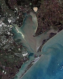
Galveston Bay is the seventh largest estuary in the United States, located along the upper coast of Texas. It is connected to the Gulf of Mexico and is surrounded by sub-tropic marshes and prairies on the mainland. The water in the bay is a complex mixture of sea water and fresh water which supports a wide variety of marine life. At an average depth of only 6 feet (1.8 m) it is unusually shallow for its size.

Buffalo Bayou is a slow-moving river which flows through Houston in Harris County, Texas. Formed 18,000 years ago, it has its source in the prairie surrounding Katy, Fort Bend County, and flows approximately 53 miles (85 km) east through the Houston Ship Channel into Galveston Bay and the Gulf of Mexico. In addition to drainage water impounded and released by the Addicks and Barker reservoirs, the bayou is fed by natural springs, surface runoff, and several significant tributary bayous, including White Oak Bayou, Greens Bayou, and Brays Bayou. Additionally, Buffalo Bayou is considered a tidal river downstream of a point 440 yards (400 m) west of the Shepherd Drive bridge in west-central Houston.

The Galveston Seawall is a seawall in Galveston, Texas, USA that was built after the Galveston Hurricane of 1900 for protection from future hurricanes. Construction began in September, 1902, and the initial segment was completed on July 29, 1904. From 1904 to 1963, the seawall was extended from 3.3 miles (5.3 km) to over 10 miles (16 km) long.

The Bolivar Bridge was a proposed bridge connecting Galveston Island and the Bolivar Peninsula in the United States state of Texas. Its intention was to replace the Bolivar Ferry, the only direct connection for traffic from Galveston Island.

Houston, the most populous city in the Southern United States, is located along the upper Texas Gulf Coast, approximately 50 miles (80 km) northwest of the Gulf of Mexico at Galveston. The city, which is the ninth-largest in the United States by area, covers 601.7 square miles (1,558 km2), of which 579.4 square miles (1,501 km2), or 96.3%, is land and 22.3 square miles (58 km2), or 3.7%, is water.

The Addicks Reservoir and Addicks Dam in conjunction with the Barker Reservoir prevent downstream flooding of Buffalo Bayou in the City of Houston. Both reservoirs were authorized under the Rivers and Harbors Act of June 20, 1938, which was modified by the Flood Control Acts of August 11, 1938; September 3, 1954; and October 27, 1965. The U.S. Army Corps of Engineers completed construction of Addicks Dam and the outlet facility in 1948.

The Port of Galveston is the port of the city of Galveston, Texas. It was established by a proclamation issued by the Congress of Mexico on October 17, 1825, while the land known today as Texas was still part of Mexico. The Port of Galveston is the oldest port in the Gulf of Mexico west of New Orleans.
The Texas City Dike is a levee located in Texas City, Texas, United States that projects nearly 5 miles (8.0 km) south-east into the mouth of Galveston Bay. It is flanked by the north-eastern tip of Galveston Island and the south-western tip of the Bolivar Peninsula. The dike, one of the area's most beloved and enduring landmarks, was originally designed to reduce the impact of sediment accumulation along the lower Bay.

Barker Reservoir is a flood control structure in Houston, Texas which prevents downstream flooding of Buffalo Bayou, the city's principal river. The reservoir operates in conjunction with Addicks Reservoir to the northeast, which impounds Mayde and Bear Creeks, two tributaries of the Buffalo. Both reservoirs were authorized under the Rivers and Harbors Act of June 20, 1938, which were modified by the Flood Control Acts of August 11, 1938; September 3, 1954; and October 27, 1965.

The History of Galveston, Texas, begins with the archaeological record of Native Americans who used the island. The first European settlements on the island were constructed around 1816. The Port of Galveston was established in 1825 by the Congress of Mexico following its successful revolution from Spain. The city served as the main port for the Texas Navy during the Texas Revolution. Galveston was founded in 1836 by Matthew Sabo and served as the capital of the Republic of Texas. The Battle of Galveston was fought in Galveston Bay during the American Civil War when Confederate forces under Major General John B. Magruder attacked and expelled occupying Union troops from the city.

Clear Creek is a small river in Southeast Texas in the United States, which channels much of the run-off in southeast Harris County into Clear Lake and Galveston Bay. Much of the length of the stream forms the boundary between Harris County and Galveston County and all of the boundary with Brazoria County. It originates in the Blue Ridge Oilfield in Fort Bend County.
The Bayport Container Terminal, or simply the Bayport Terminal, is a major deep water port in the Greater Houston area in Texas. This relatively new terminal, part of the Port of Houston, is designed to handle standardized cargo containers and offload the nearby Barbours Cut Terminal, which has no further room for expansion. The Bayport Terminal is situated along the Bayport Ship Channel off Galveston Bay, between La Porte, Texas and Seabrook, Texas. This channel itself feeds into the larger Houston Ship Channel, which runs from Houston, through Galveston Bay, to the Gulf of Mexico.

The American Shore and Beach Preservation Association (ASBPA) is a private, nonprofit organization formed in 1926. It was founded to address coastal erosion and the loss of sand on America's beaches. Today, ASBPA is an association of beach and coastal practitioners, including beach towns and managers, coastal engineers, coastal geologists, dredging and ecological restoration companies, coastal academics and students. ASBPA advances coastal science and coastal engineering through its peer-reviewed journal, Shore & Beach, and an annual technical conference. It also hosts an annual coastal summit in Washington, DC to advocate for coastal policies.

Brays Bayou is a slow-moving river in Harris County, Texas. A major tributary of Buffalo Bayou, the Brays flows for 31 miles (50 km) from the western edge of the county, south of Barker Reservoir along the border with Fort Bend County, east to its convergence with the Buffalo at Harrisburg. Nearly all of the river is located within the city of Houston; it is a defining geographic feature of many neighborhoods and districts, including Meyerland, Braeswood Place, the Texas Medical Center, and Riverside Terrace.


