Related Research Articles

The Islamabad Capital Territory is the only federal territory of Pakistan and contains Islamabad, the capital of Pakistan. Located on the northern edge of the Pothohar Plateau and at the foot of the Margalla Hills, The ICT shares borders with the province of Khyber Pakhtunkhwa in the west and with the province of Punjab in the remaining directions. It covers an area of 906.5 square kilometres and according to the 2023 national census, has a population of over 1 million in the city proper, while over 2 million in the whole territory. The territory is represented in the National Assembly by NA-52, NA-53, and NA-54 constituencies and by four seats in the Senate.
Islamabad is the capital city of the Islamic Republic of Pakistan. It is the country's ninth-most populous city with a population of over 1.2 million people and is federally administered by the Pakistani government as part of the Islamabad Capital Territory. Built as a planned city in the 1960s and established in 1967, it replaced Karachi as Pakistan's official national capital.

Abbottabad District is a district in the Khyber Pakhtunkhwa province of Pakistan. It is part of the Hazara Division and Hazara region covers an area of 1,969 km2, with the city of Abbottabad being the principal town. Neighbouring districts include Mansehra to the north and Haripur to the west in Khyber Pakhtunkhwa, Muzaffarabad to the east in Azad Jammu and Kashmir and Rawalpindi to the south in the Punjab province.
Haripur District is a district in the Hazara Division of Khyber Pakhtunkhwa, Pakistan.

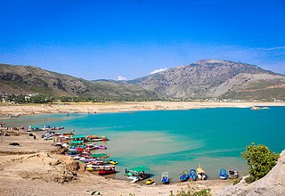
Haripur is a historical city in Hazara Division of Khyber Pakhtunkhwa Pakistan. With Swabi and Buner to the west, some 65 km (40 mi) north of Islamabad and 35 km Khanpur Road Tofkian Valley Taxila and 35 km (22 mi) south of Abbottabad. It is in a hilly plain area at an altitude of 520 m (1,706 ft).

Margalla Hills National Park is a national park in Pakistan located in Islamabad Capital Territory, near its northern boundary with Haripur District, Khyber Pakhtunkhwa. The park includes the Margalla Hills, which form the foothills of the Himalayas, along with Shakarparian Park and Rawal Lake.

The Margalla Hills are a hill range within the Margalla Hills National Park on the northern edge of Islamabad Capital Territory, Pakistan, just south of Haripur District, Khyber Pakhtunkhwa. They are part of the Himalayan foothills. The Margalla range has an area of 12,605 hectares. It is a range with many valleys as well as high mountains.

Capital Development Authority, is a public benefit corporation responsible for providing municipal services in Islamabad Capital Territory. The CDA was established on 14 June 1960 by executive order entitled Pakistan Capital Regulation. As of 2016, most of CDA's municipal services and departments have been transferred to the newly created Islamabad Metropolitan Corporation, although CDA is still in charge of estate management, project execution and sector developments.

Islamabad is located in the Pothohar Plateau in the northern part of Pakistan, within the Islamabad Capital Territory. It is a well-organized city divided into different sectors and zones. It was ranked as a Gamma + world city in 2020. The city is home to Pakistan Monument, which is built on top of a hill in Shakarparian, and the Faisal Mosque, one of the largest mosques in South Asia and the sixth -largest mosque as per area in the world. The Capital Development Authority is tasked with developing the city and its facilities.
Losar Baoli is a stepwell in the Margalla Hills of the Islamabad Capital Territory, Pakistan. Near the town of Shah Allah Ditta in the Potohar Plateau, the area was a passageway for caravans and armies moving along the east–west direction.

Shah Allah Ditta is a centuries-old village and a union council located at the foothills of the Margalla Hills in the Islamabad Capital Territory, Pakistan. It s located adjacent to Sector D-12 of Islamabad.

The transport system in Islamabad, the capital of Pakistan, connects it with all major cities and towns via regular trains and bus services running mostly from the neighbouring city of Rawalpindi.

Zero Point Interchange is a large cloverleaf interchange in Islamabad, Pakistan. It is located at the intersection of Islamabad Highway, Srinagar Highway, and Khayaban-e-Suharwardy. It was inaugurated in 5 July 2011, and has an estimated life of 30 years.
Al-Hamra is a housing project launched by Shaheen Foundation in 2005 for the officers of Pakistan Air Force.

Jarral is one of the 57 union councils of Abbottabad District in the Khyber Pakhtunkhwa province of Pakistan.
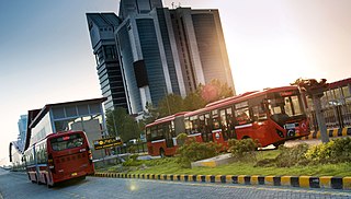
The Rawalpindi-Islamabad Metrobus is a 83.6 km (51.9 mi) bus rapid transit system operating in the Islamabad–Rawalpindi metropolitan area of Pakistan. It consists of four routes, namely the Red, Orange, Blue, and Green Lines. The Red and Orange Lines have dedicated lanes with proper stations built along them, while the Blue and Green Lines currently run along the Islamabad Expressway and Srinagar Highway respectively, with regular traffic.
I-11 is a sector of Islamabad, Pakistan. It is a lightly built area, located on the southwestern edge of the city. I-11 borders Rawalpindi to the south and neighbors I-10 and I-12, while sectors H-10, H-11 and H-12 are located adjacent. CDA has taken the possession of land from illegal encroachers and land grabbers and development work has started to hand over the possession to original owners of the plots.

The Margalla Avenue or Margalla Expressway is a 33-kilometer six-lane highway in the Margalla Hills area in the suburbs of Islamabad, Pakistan. It was planned in 1966, but work on it was stalled till 2021. The road is an alternative to the Srinagar Highway, and provides easy access of the tenth and eleventh sectors of Islamabad to the N-5 National Highway. This road is a crucial section of the larger Rawalpindi Ring Road project as it connects the town of Sangjani to the town of Barakahu.
Karnal Sher Khan Shaheed Road, previously known as the IJP Road, or the Inter-Junction Principal Road, is one of the busiest roads in the Islamabad–Rawalpindi metropolitan area in Pakistan, connecting Islamabad to Rawalpindi. It also serves as a route for traffic coming from Punjab and Azad Kashmir going towards Taxila, Attock, and onwards to Khyber Pakhtunkhwa. It is named IJ Principle Road because it is the road that was going to be between the never-built Sector J and Sector I of Islamabad.
Sikander-e-Azam Road is a roadway project in Islamabad, Pakistan that is aimed at promoting Gandhara tourism.
References
- 1 2 3 "CDA to Construct 'Alexander Road' Linking Islamabad with Haripur - ProProperty".
- 1 2 "Alexander Road linking Islamabad with Haripur to cost Rs600 million". Thenews.com.pk. 2023-07-05. Retrieved 2023-07-09.
- ↑ "CDA set to begin construction work on Alexander road". 20 June 2023.
| National Highways |
| |||||
|---|---|---|---|---|---|---|
| Motorways | ||||||
| Expressways | ||||||
| Provincial Highways | ||||||