
Morocco is the northwesternmost country which spans from the Mediterranean Sea and Atlantic Ocean on the north and the west respectively, into large mountainous areas in the interior, to the Sahara desert in the far south. Morocco is a Northern African country, located in the extreme northwest of Africa on the edge of continental Europe. The Strait of Gibraltar separates Spain from Morocco with a 13 kilometres (8.1 mi) span of water. Morocco borders the North Atlantic Ocean to the west, and the western Mediterranean Sea to the north, and has borders with Algeria and disputed Western Sahara.

Jaén is a municipality of Spain and the capital of the province of Jaén, in the autonomous community of Andalusia.

Mérida is a city and municipality of Spain, part of the Province of Badajoz, and capital of the autonomous community of Extremadura. Located in the western-central part of the Iberian Peninsula at 217 metres above sea level, the city is crossed by the Guadiana and Albarregas rivers. The population was 60,119 in 2017.

Sierra Nevada is a mountain range in the Andalusian province of Granada in Spain. It contains the highest point of continental Spain: Mulhacén, at 3,479 metres (11,414 ft) above sea level.

Málaga is a municipality of Spain, capital of the Province of Málaga, in the autonomous community of Andalusia. With a population of 578,460 in 2020, it is the second-most populous city in Andalusia and the sixth most populous in the country. It lies in Southern Iberia on the Costa del Sol of the Mediterranean, primarily in the left bank of the Guadalhorce. The urban core originally developed in the space between the Gibralfaro Hill and the Guadalmedina.
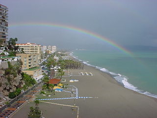
Torremolinos is a municipality in Andalusia, southern Spain, west of Málaga. A poor fishing village before the growth in tourism began in the late 1950s, Torremolinos was the first of the Costa del Sol resorts to be developed and is still the most popular in the region.

Almería is a city and municipality of Spain, located in Andalusia. It is the capital of the province of the same name. It lies in southeastern Iberia on the Mediterranean Sea. Caliph Abd al-Rahman III founded the city in 955. The city grew wealthy during the Islamic era, becoming a world city throughout the 11th and 12th centuries. It enjoyed an active port that traded silk, oil, and raisins. Being adjacent to a small desert, Almería has an exceptionally dry climate by European standards.

The town of Rota is a Spanish municipality located in the Province of Cádiz, Andalusia. Its surface area is 84 km2 and is bordered by the towns of Chipiona, Sanlúcar de Barrameda and El Puerto de Santa María. It is located near the city of Jerez de la Frontera and is 36 kilometers away from the provincial capital, Cadiz. It had in the year 2009 28,516 inhabitants, with a density of 339 inhabitants / km2. It belongs to two associations, the Association of Municipalities of Cadiz Bay along with the municipalities of Cadiz, Jerez de la Frontera, El Puerto de Santa María, San Fernando, Chiclana and Puerto Real; and the Association of Municipalities of the Lower Guadalquivir that comprises municipalities of Northwest Coast of Andalusia.

Roque de los Muchachos Observatory is an astronomical observatory located in the municipality of Garafía on the island of La Palma in the Canary Islands, Spain. The observatory site is operated by the Instituto de Astrofísica de Canarias, based on nearby Tenerife. ORM is part of the European Northern Observatory.

Vega de San Mateo is a town and a municipality in the mountainous central part of the island of Gran Canaria in the Province of Las Palmas in the Canary Islands. Its population is 7,774 (2013), and the area is 37.89 km2. Vega de San Mateo is located 17 km southwest of Las Palmas.

Güímar is the name of a municipality, town and valley in the eastern part of the Spanish island of Tenerife, one of the Canary Islands, and part of Santa Cruz de Tenerife (province). The municipality extends for 102.9 square kilometers from the mountainous interior to the beaches on the Atlantic, and borders the municipalities of La Orotava, Arafo and Fasnia. Its estimated population is 18,589 (2013). The TF-1 motorway passes through the municipality.

Adeje is a town and municipality in the southwestern part of the island of Tenerife, one of the Canary Islands, and part of the province of Santa Cruz de Tenerife, Spain. The town Adeje is located 4 km from the coast, 8 km north of the resort town Los Cristianos, 60 km southwest of the island capital Santa Cruz de Tenerife and about 17 km northwest of Tenerife South Airport.

Osuna is a town and municipality in the province of Seville, southern Spain, in the autonomous community of Andalusia. As of 2009, it has a population of c. 17,800. It is the location of the Andalusian Social Economy School.

Montoro is a municipality of Spain belonging to the province of Córdoba, Andalusia. Housing lies on a bend of the river Guadalquivir, which envelopes from West, North, and East.

Europe is generally characterized by a temperate climate. Most of Western Europe has an Oceanic climate, in the Köppen climate classification, featuring cool to warm summers and cool winters with frequent overcast skies. Southern Europe has a distinctively Mediterranean climate, which features warm to hot, dry summers and cool to mild winters and frequent sunny skies. Central-eastern Europe is classified as having a humid continental climate, which features warm to hot summers and cold winters.
La Rambla is a municipality in the province of Córdoba, Spain.

The climate of Spain is highly diverse and varies considerably across the country's various regions. In fact, Spain is sometimes described as the most climatically diverse country in Europe and has 13 different Köppen, climates.

Storm Blas was a small extratropical cyclone and Mediterranean tropical-like cyclone that caused devastation and disruption across the Balearic Islands, Spain, France, and Italy during early and mid-November 2021. The storm was named by Agencia Estatal de Meteorología (AEMET) on 5 November, with the agency issuing wind and rain alerts to the Balearic archipelago and other areas reaching the eastern coasts of Spain, as Blas approached from the east. It then turned eastward after moving slowly westward, and the storm meandered across the western Mediterranean for the next several days, before eventually dissipating to the west of Italy on 18 November.
