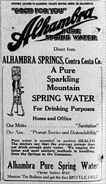
Alhambra Springs

Last updated

Alhambra Springs
Crop from Collections.library.yale.edu 10993196 Alhambra Natural Mineral Water Springs near Martinez, California.jpg
LocationNear Martinez, Contra Costa County, California, U.S.

Alhambra Springs is or was a group of natural springs in the hills of Contra Costa County, California, United States. The six spring vents were located on a hillside south of Martinez, above Alhambra Creek in the vicinity of Briones Regional Park. In the 20th century, Alhambra Springs was a popular locally bottled water in Northern California. The springs are no longer commercialized, but Alhambra remains a brand name, and as of 2008 there was still a "trickle" of water at Alhambra Springs.

Contents

History

According to a 1907 account, a drive from Oakland of an hour and a half or a train ride on the Southern Pacific Railroad would deliver you to the vicinity of the springs, which were "situated at the head of the picturesque Alhambra Valley...and the property of which they form a part consists of one hundred and ninety acres of beautifully wooded country diversified by hills and ferny cañons." [1] Alhambra Springs are in the vicinity of what is now Briones Regional Park. [2]

The Smith family had opened the Alhambra Springs Resort in the 1890s. [3] In 1895 the springs were advertised "for rent", [4] and in 1897 they were for sale, at which time there were six rental cottages on the 109-acre (44 ha) property. [5] Bottling of the water for sale began around 1898. [6] During this period, a "shrewd businessman" named Loron M. Lasell ran a general store and a hardware store in Martinez, [7] and he "allowed customers from his general store to shop on credit. A generous year often went by before he attempted collecting on past due accounts. If you couldn't pay in cash you could pay with an acre or two of land." [8] According to his grandson, between 1894 and 1921 Lasell acquired almost 300 acres "from Elam Smith, F. M. Smith, John Zurfluh, Gertrude Upham...including that property known as Alhambra Springs." [9]

Bottling plant c. 1904 Collections.library.yale.edu 10993196 Alhambra Natural Mineral Water Springs near Martinez, California 02.jpg
Bottling plant c.1904

Lasell, who also claimed to be a skilled dowser, [8] soon established Alhambra Springs Water Company. [8] The founding date was said to be 1902, per a radio jingle that ran for many years: "Alhambra water is good for you since 1902". [8] Around 1905 Lasell ran a two-inch-diameter galvanized steel pipe [3] 8 miles (13 km) from the spring to a bottling plant in town with easy access to the railroad and nearby docks. [8] At one time the company ran up to 33 delivery trucks, [8] and had distribution centers in San Francisco and Oakland. [8] Alhambra water was shipped throughout California, as well as to Arizona, Mexico, and the Hawaiian Islands. [10] At one point Lasell was offered a Coca-Cola distributorship, [8] but turned it down because Alhambra had its own line of "carbonated root beer, ginger ale, and creme soda". [11] The business was profitable enough that Lasell was able to expand supply by purchasing Big Bear Mountain Springs in the Oakland Hills. [8] In the 1940s a five-gallon water bottle was sold for 50 cents. [8] The Lasell brothers sold out in the 1950s, to either the National Ice Company of San Francisco in 1951, [12] or Foremost-McKesson in 1952. [8] In 1956, a catastrophic fire at the bottling plant on Marina Vista in Martinez destroyed the old building. [13] [8]

George Archinal photograph of the 1956 Alhambra bottling plant fire, for the Independent of Richmond, California George Archinal photograph - Richmond Independent - 1956-12-06 - Fire Razes Martinez Landmark.jpg
George Archinal photograph of the 1956 Alhambra bottling plant fire, for the Independent of Richmond, California

According Ernest Lasell in 1976, "The business has been sold several times since then and still maintains the name Alhambra Water although they do not use water from Alhambra Springs." [12] The Alhambra brand was advertised up until the 1980s with commercials that featured "a smiling Alhambra water deliveryman, with a 5-gallon jug slung over his shoulder, striding up a walkway of a suburban home singing, 'Me and Alhambra water makin' friends.'" [11] Alhambra brand water is still delivered as of 2024. [14]

The springs property remained in the hands of five Lasell cousins as of 1976. [12] By 1990 a newspaper account had it that "the area now is in the midst of development." [8] In 2008 the 83-acre (34 ha) property where the springs emerge was being listed for sale for $2.5 million. [11] At that time a "stream of water" still "trickled from a roadside spot". [11]

Legacy

Water profile

"Drink Alhambra Mineral Water" Napa Journal, July 4, 1909 "Drink Alhambra Mineral Water" Napa Journal, July 4, 1909.jpg
"Drink Alhambra Mineral Water" Napa Journal, July 4, 1909

A 1907 article about California springs written by regional boosters claimed that Alhambra water had a "natural supply of bicarbonates, which adds agreeably to its pleasant taste, and it is sold both in its natural state and also charged with additional carbonic-acid gas. The minerals in the water have a soothing effect upon the lining of the digestive organs, and it is a valuable remedy for rheumatism and disorders of the stomach." [1]

In 1915, U.S. government geologist Gerald A. Waring classified Alhambra as one of the "saline springs" of California, writing that they were "small saline and sulphated springs whose waters have been bottled for medicinal use...the principal springs contain large amounts of sodium and chlorine...Of the three principal springs on the [Alhambra] property, one which is known as No. 1, fills a housed-in pool six feet square and a foot deep, on the eastern bank of the ravine; its water tastes strongly saline and sulphated...A fourth spring has a flow of a little over half a gallon a minute and is designated in the table of analyses as 'Alhambra'...the water of Spring No. 2 is less strongly mineralized than that of the others and is characterized chiefly by secondary alkahnity...The rocks near Alhambra Springs are of the same character as those at Ferndale Springs half a mile to the northwest, which have been described among the carbonated springs..." [17]

A 1916 report had it that the bottled water from the specific spring called Alhambra "contains the salts of Sodium, Magnesium and traces of Iron and Aluminum." [18] California geologists reported in 1921 that "A group of 6 more or less mineralized springs are situated in a narrow cañon 6 miles south of Martinez in section 2, T. 1N., R. 3W. Three of the springs have been developed, but of these only two are utilized. The principal spring, known as No. 1, fills a housed-in pool 6 feet square on the eastern bank of the ravine. It is strongly saline, as shown in the analysis below. No. 2 spring rises in a cement-covered joint on the western edge of the stream channel several hundred yards south of No. 1. The waters of No. 2 are less strongly mineralized." [19]

Additional images

See also

Related Research Articles

<span class="mw-page-title-main">Contra Costa County, California</span> County in California, United States

Contra Costa County is a county located in the U.S. state of California, in the East Bay of the San Francisco Bay Area. As of the 2020 United States Census, the population was 1,165,927. The county seat is Martinez. It occupies the northern portion of the East Bay region of the San Francisco Bay Area and is primarily suburban. The county's name refers to its position on the other side of the bay from San Francisco. Contra Costa County is included in the San Francisco–Oakland–Berkeley, CA Metropolitan Statistical Area.

<span class="mw-page-title-main">Martinez, California</span> City in California, United States

Martinez is a city and the county seat of Contra Costa County, California, United States, in the East Bay region of the San Francisco Bay Area. Located on the southern shore of the Carquinez Strait, the city's population was 37,287 at the 2020 census. The city is named after Californio ranchero Ygnacio Martínez, having been founded on his Rancho El Pinole. Martinez is known for its historic center and its waterfront.

<span class="mw-page-title-main">Interstate 680 (California)</span> Interstate highway in California

Interstate 680 (I-680) is a north–south auxiliary Interstate Highway in Northern California. It curves around the eastern cities of the San Francisco Bay Area from San Jose to I-80 at Fairfield, bypassing cities along the eastern shore of San Francisco Bay such as Oakland and Richmond while serving others more inland such as Pleasanton and Concord.
<span class="mw-page-title-main">County Connection</span> Public transit agency in Contra Costa County, California

The County Connection is a Concord-based public transit agency operating fixed-route bus and ADA paratransit service in and around central Contra Costa County in the San Francisco Bay Area. Established in 1980 as a joint powers authority, CCCTA assumed control of public bus service within central Contra Costa first begun by Oakland-based AC Transit as it expanded into suburban Contra Costa County in the mid-1970s. In 2023, the system had a ridership of 2,661,400, or about 9,900 per weekday as of the fourth quarter of 2023.

<span class="mw-page-title-main">John Muir National Historic Site</span> National Historic Site of the United States

The John Muir National Historic Site is located in the San Francisco Bay Area, in Martinez, Contra Costa County, California. It preserves the 14-room Italianate Victorian mansion where the naturalist and writer John Muir lived, as well as a nearby 325-acre tract of native oak woodlands and grasslands historically owned by the Muir family. The main site is on the edge of town, in the shadow of State Route 4, also known as the "John Muir Parkway."

<span class="mw-page-title-main">Martinez station</span> Train station in Martinez, California, US

Martinez station is an Amtrak passenger train station in Martinez, California, United States. Located at the west end of downtown Martinez, the station has one side platform and one island platform, which serve three of the four tracks of the Union Pacific Railroad Martinez Subdivision. It is served by the daily California Zephyr and Coast Starlight long-distance trains, five daily round trips of the San Joaquin corridor service, and fifteen daily round trips of the Capitol Corridor service. Martinez is also served by Amtrak Thruway buses plus County Connection, Tri-Delta Transit, and WestCAT local buses.
<span class="mw-page-title-main">Los Encinos State Historic Park</span> State park in Los Angeles County

Los Encinos State Historic Park is a state park unit of California, preserving buildings of Rancho Los Encinos. The park is located near the corner of Balboa and Ventura Boulevards in Encino, California, in the San Fernando Valley. The rancho includes the original nine-room de la Ossa Adobe, the two-story limestone Garnier building, a blacksmith shop, a natural spring, and a pond. The 4.7-acre (1.9 ha) site was established as a California state park in 1949.

<span class="mw-page-title-main">Alhambra Creek</span> River in California, United States

Alhambra Creek is a stream in Contra Costa County, in the East Bay region of the San Francisco Bay Area in northern California.

Rancho Las Juntas was a 13,293-acre (53.79 km2) Mexican land grant in present day Contra Costa County, California given in 1844 by Governor Manuel Micheltorena to William Welch. The name Las Juntas translates as "the Crossroads". The grant was located between Ygnacio Martinez’ Rancho El Pinole and Salvio Pacheco’s Rancho Monte del Diablo, and included northwestern Walnut Creek, all of Pleasant Hill, and the eastern portion of Martinez. The original borders of the claim were defined as the straits to the north, "Las Juntas" to the south, the Walnut creek to the east, the Reliz ridge to the west, and, to the northwest, the Alhambra creek.

<span class="mw-page-title-main">Tuscan Springs</span> Geothermal feature in California

Tuscan Springs are a group of springs in the U.S. state of California. Tuscan Springs was named for the fact its borax-impregnated waters were chemically similar to the springs of Tuscany, in Italy.

<span class="mw-page-title-main">Bradford Island</span> Island in California

Bradford Island is a 2,172-acre (879 ha) island of the Sacramento–San Joaquin River Delta, in Contra Costa County, California, United States. Bradford Island is inaccessible by roads, and is served by a ferry across the False River from nearby Jersey Island. Approximately 48 people lived on the island as of 2020. Other uses of land include wheat farming, cattle grazing, and natural gas extraction.

<span class="mw-page-title-main">Kimball Island</span> Island in California

Kimball Island is a small island in the Sacramento–San Joaquin River Delta. It is located in Sacramento County, California, in the United States. Since its discovery, it has been used to grow barley, farm fish, cultivate cannabis, and as residential land. Currently, however, it is uninhabited; since 2000, it has been left to "forever be a wetland habitat", and is sometimes used as a fishing spot.

<span class="mw-page-title-main">Mallard Island</span> Island in California

Mallard Island is a small island in Suisun Bay, at the confluence of the Sacramento and San Joaquin rivers. It is part of Contra Costa County, California. Its coordinates are 38°02′31″N121°55′07″W, and the United States Geological Survey measured its elevation as 3 ft (0.91 m) in 1981. It appears in a 1953 USGS map of the area.

<span class="mw-page-title-main">Palm Tract</span> Island in California

The Palm Tract is an island in the Sacramento–San Joaquin River Delta. It is part of Contra Costa County, California. It, along with Orwood Tract to the south, are managed by Reclamation District 2024. Its coordinates are 37°57′14″N121°35′22″W, and the United States Geological Survey measured its elevation as 10 ft (3.0 m) in 1981. It appears on 1913 and 1952 United States Geological Survey maps of the area.

<span class="mw-page-title-main">Louis Lorenz Stein</span>

Louis Lorenz Stein Jr. was an American pharmacist, California East Bay historian and archivist. He is best known for founding the Arlington Pharmacy in Kensington, California and the pharmacy museum at Columbia State Historic Park and for donating collections of historical materials to various California historical societies and museums.
<span class="mw-page-title-main">Gaviota Hot Springs</span> Geothermal site in California

Gaviota Hot Springs is a geothermal feature in Santa Barbara County, California, United States. The two pools are accessible from the Gaviota Peak trail in Gaviota State Park. Gaviota Hot Springs is sometimes called Las Cruces Hot Springs or Sulphur Springs. The hot springs lie within the Hot Springs Creek watershed, near the junction of U.S. Route 101 and California State Route 1.
<span class="mw-page-title-main">Veronica Springs</span> Historic mineral spring, California

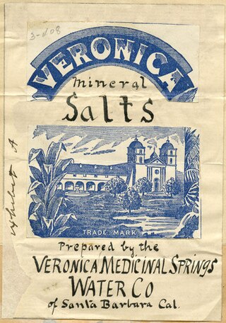
Veronica Springs, also Veronica Medicinal Springs, was a cluster of natural springs along Arroyo Burro creek in Santa Barbara County, California, United States. Veronica spring water was not a therapeutic spa water or a table water but a medicinal mineral water with high magnesium levels. The waters had a yellowish tinge and a strongly purgative-laxative effect, and beginning around 1887, the water was bottled and sold as a health tonic. Veronica Water peaked as a brand in the 1910s. The springs were capped off in 1962.

<span class="mw-page-title-main">Tolenas Springs</span> Water source in California

Tolenas Springs is a group of natural carbonated-water soda springs in the hills of Solano County, California, United States. The springs emerge from a formation of travertine that has been intermittently quarried for building material. The springs are located on private property and are closed to the public.

<span class="mw-page-title-main">Console Springs</span> Body of water, California

Console Springs was a natural spring in Reche Canyon, Riverside County, California, United States. The waters were bottled for sale in the early 20th century.

<span class="mw-page-title-main">El Granito Springs</span> Water source in California

El Granito Springs was a natural spring in the vicinity of present-day La Mesa in eastern San Diego County, California, United States. The springs were named for their location in a granite outcropping near the San Diego River.

References

  1. 1 2 Hughes (1907), p. 8.
  2. Mutnick (1976a), p. 1.
  3. 1 2 Alhambra Creek Watershed Assessment (1997), p. 8.
  4. "[classified ad at bottom of column 6]". The San Francisco Call. San Francisco, California. June 4, 1895. p. 11. ISSN   1941-0719 . Retrieved 2024-02-25 via National Endowment for the Humanities, Chronicling America.
  5. "Alhambra Mineral Springs for sale". San Francisco Chronicle. May 1, 1897. p. 10. Retrieved 2024-02-25 via Newspapers.com.
  6. Waring (1915), p. 294.
  7. Kathman (1990), p. 1.
  8. 1 2 3 4 5 6 7 8 9 10 11 12 13 Kathman (1990), p. 2.
  9. Lasell (1976), p. 1.
  10. Hughes (1907), p. 9.
  11. 1 2 3 4 White (2008).
  12. 1 2 3 Lasell (1976), p. 2.
  13. Richmond Independent (1956).
  14. "Alhambra® Bottled Spring Water | 5-Gallon Bottled Water". www.alhambrawater.com. Retrieved 2024-03-03.
  15. Caroompas (2011).
  16. "Vintage 5 Gallon Alhambra National Water Bottle | #129859890". Worthpoint. Retrieved 2024-03-03.
  17. Waring (1915), p. 293–294.
  18. Sanders (1916), p. 220.
  19. Huguenin & Castello (1921), p. 56.

Books

Articles

Further reading