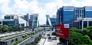
Haryana is an Indian state located in the northern part of the country. It was carved out of the former state of East Punjab on 1 November 1966 on a linguistic basis. It is ranked 21st in terms of area, with less than 1.4% of India's land area. The state capital is Chandigarh, which it shares with the neighbouring state of Punjab; and the most populous city is Faridabad, which is a part of the National Capital Region. The city of Gurgaon is among India's largest financial and technology hubs. Haryana has 6 administrative divisions, 22 districts, 72 sub-divisions, 93 revenue tehsils, 50 sub-tehsils, 140 community development blocks, 154 cities and towns, 7,356 villages, and 6,222 villages panchayats.

India is the most populous country in the world with one-sixth of the world's population. According to UN estimates, India overtook China in having the largest population in the world with a population of 1,425,775,850 at the end of April 2023.

Delhi, officially the National Capital Territory (NCT) of Delhi, is a city and a union territory of India containing New Delhi, the capital of India. Lying on both sides of the Yamuna river, but chiefly to the west, or beyond its right bank, Delhi shares borders with the state of Uttar Pradesh in the east and with the state of Haryana in the remaining directions. Delhi became a union territory on 1 November 1956 and the NCT in 1995. The NCT covers an area of 1,484 square kilometres (573 sq mi). According to the 2011 census, Delhi's city proper population was over 11 million, while the NCT's population was about 16.8 million.

Jammu and Kashmir was a region formerly administered by India as a state from 1952 to 2019, constituting the southern and southeastern portion of the larger Kashmir region, which has been the subject of a dispute between India, Pakistan and China since the mid-20th century. The underlying region of this state were parts of the former princely state of Jammu and Kashmir, whose western districts, now known as Azad Kashmir, and northern territories, now known as Gilgit-Baltistan, are administered by Pakistan. The Aksai Chin region in the east, bordering Tibet, has been under Chinese control since 1962.

Coimbatore, sometimes shortened as Kovai, is one of the major metropolitan cities in the Indian state of Tamil Nadu. It is located on the banks of the Noyyal River and surrounded by the Western Ghats. Coimbatore is the second largest city in Tamil Nadu after Chennai in terms of population and the 16th largest urban agglomeration in India as per the census 2011. It is the administrative capital of Coimbatore District and is administered by the Coimbatore Municipal Corporation which was established in 1981.

Languages spoken in the Republic of India belong to several language families, the major ones being the Indo-Aryan languages spoken by 78.05% of Indians and the Dravidian languages spoken by 19.64% of Indians; both families together are sometimes known as Indic languages. Languages spoken by the remaining 2.31% of the population belong to the Austroasiatic, Sino–Tibetan, Tai–Kadai, and a few other minor language families and isolates. According to the People's Linguistic Survey of India, India has the second highest number of languages (780), after Papua New Guinea (840). Ethnologue lists a lower number of 456.

Nellore is a city located on the banks of Penna River, in Nellore district of the Indian state of Andhra Pradesh. It serves as the headquarters of the district, as well as Nellore mandal and Nellore revenue division. It is the fourth most populous city in the state. It is at a distance of 279 kilometres (173 mi) from Vijayawada and about 170 km (110 mi) north of Chennai, Tamil Nadu and also about 380 km (240 mi) east-northeast of Bangalore, Karnataka.

Tripura is a state in Northeast India. The third-smallest state in the country, it covers 10,491 km2 (4,051 sq mi); and the seventh-least populous state with a population of 3.67 million. It is bordered by Assam and Mizoram to the east and by Bangladesh to the north, south and west. Tripura is divided into 8 districts and 23 sub-divisions, where Agartala is the capital and the largest city in the state. Tripura has 19 different tribal communities with a majority Bengali population. Bengali, English and Kokborok are the state's official languages.

Nagaland is a landlocked state in the north-eastern region of India. It is bordered by the Indian states of Arunachal Pradesh to the north, Assam to the west, Manipur to the south, and the Naga Self-Administered Zone of the Sagaing Region of Myanmar (Burma) to the east. Its capital city is Kohima and its largest city is the twin Chümoukedima–Dimapur. The state has an area of 16,579 square kilometres (6,401 sq mi) with a population of 1,980,602 as per the 2011 Census of India, making it one of the smallest states of India.
Ballari or Bellary, in the eponymous Ballari district, is a city in the state of Karnataka, India.

Allur is a Town in Nellore district of the Indian state of Andhra Pradesh. It is the headquarters of Allur Mandal of Kavali revenue division.
The 2001 census of India was the 14th in a series of censuses held in India every decade since 1871.

The 2011 census of India or the 15th Indian census was conducted in two phases, house listing and population enumeration. The House listing phase began on 1 April 2010 and involved the collection of information about all buildings. Information for National Population Register (NPR) was also collected in the first phase, which will be used to issue a 12-digit unique identification number to all registered Indian residents by Unique Identification Authority of India. The second population enumeration phase was conducted between 9 and 28 February 2011. Census has been conducted in India since 1872 and 2011 marks the first time biometric information was collected. According to the provisional reports released on 31 March 2011, the Indian population increased to 1.21 billion with a decadal growth of 17.70%. Adult literacy rate increased to 74.04% with a decadal growth of 9.21%. The motto of the census was Our Census, Our Future.

The Kashmir division is a revenue and administrative division of the Indian-administered Jammu and Kashmir in the disputed Kashmir region. It comprises the Kashmir Valley, bordering the Jammu Division to the south and Ladakh to the east. The Line of Control forms its boundary with the Pakistani-administered territories of Gilgit−Baltistan and Azad Jammu and Kashmir to the north and west and west, respectively.
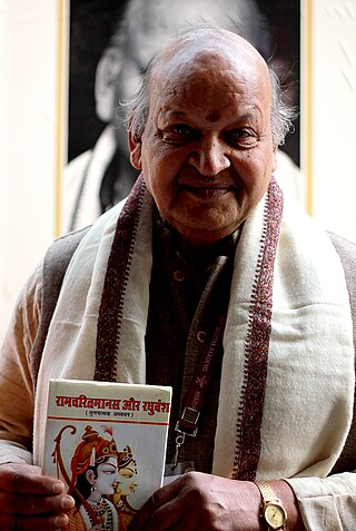
Rama Kant Shukla was an Indian scholar of Sanskrit and Hindi languages. The Government of India honoured him, in 2013, by awarding him the Padma Shri, the fourth highest civilian award, for his contributions to the fields of literature.

Jammu and Kashmir is a region administered by India as a union territory and consists of the southern portion of the larger Kashmir region, which has been the subject of a dispute between India and Pakistan since 1947 and between India and China since 1959. The Line of Control separates Jammu and Kashmir from the Pakistani-administered territories of Azad Kashmir and Gilgit-Baltistan in the west and north. It lies to the north of the Indian states of Himachal Pradesh and Punjab and to the west of Ladakh which is administered by India as a union territory.


