Dzitbalché is a large town in the extreme northern part of the Mexican state of Campeche. It is located at 20.32°N 90.05°W and serves as the municipal seat for the municipality of the same name. As of 2010, Dzitbalché had a population of 11,686, up from 10,951 at the 2005 census, making it the sixth-largest community in the state. Before the creation of the municipality of Dzitbalché on 1 January 2021, it was the second-largest community in the municipality of Calkiní.

The Prince Charles Mountains are a major group of mountains in Mac. Robertson Land in Antarctica, including the Athos Range, the Porthos Range, and the Aramis Range. The highest peak is Mount Menzies, with a height of 3,228 m (10,591 ft). Other prominent peaks are Mount Izabelle and Mount Stinear. These mountains, together with other scattered peaks, form an arc about 420 km (260 mi) long, extending from the vicinity of Mount Starlight in the north to Goodspeed Nunataks in the south.
Itapuca is a Brazilian municipality in the state of Rio Grande do Sul.
German submarine U-317 was a Type VIIC/41 U-boat of Nazi Germany's Kriegsmarine during World War II.

Palomares del Río is a city located in the province of Seville, Spain. According to the 2021 census (INE), the city has a population of 9020 inhabitants.

Ambohimalaza is a municipality in northern Madagascar. It belongs to the district of Sambava, which is a part of Sava Region. The population of the commune was estimated to be approximately 8,000 in 2001 commune census.

Ibiaçá is a municipality in the state of Rio Grande do Sul, Brazil. As of 2020, the estimated population was 4,699.

Liv Glacier is a steep valley glacier, 40 nautical miles long, emerging from the Antarctic Plateau just southeast of Barnum Peak and draining north through the Queen Maud Mountains to enter Ross Ice Shelf between Mayer Crags and Duncan Mountains. It was discovered in 1911 by Roald Amundsen, who named it for the daughter of Fridtjof Nansen.

Finsterwalder Glacier is a glacier on the northwest side of Hemimont Plateau, 2 nautical miles wide and 10 nautical miles long, flowing southwest from the central plateau of Graham Land, Antarctica, toward the head of Lallemand Fjord. Its mouth lies between the mouths of Haefeli Glacier and Klebelsberg Glacier, the three glaciers merging with Sharp Glacier where the latter enters the fjord. It was first surveyed from the plateau in 1946–47 by the Falkland Islands Dependencies Survey, and named by them for Sebastian Finsterwalder and his son, Richard Finsterwalder, German glaciologists.

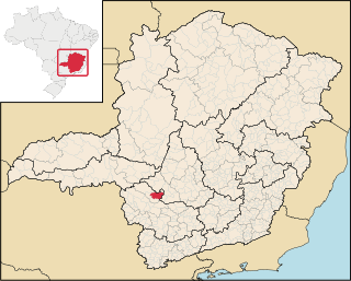
Piumhi is a Brazilian municipality located in the west of the state of Minas Gerais. Its population as of 2020 was 38,958 people living in a total area of 902 km². The city belongs to the meso-region of Oeste de Minas and Alto Paranaíba and to the micro-region of Piumhi. It became a municipality in 1868.
Salicas is a municipality and village in La Rioja Province in northwestern Argentina.
Palo Blanco is a village and municipality in Catamarca Province in northwestern Argentina.

Antevs Glacier, also known as North Heim Glacier, is a glacier on Arrowsmith Peninsula, Graham Land, flowing north between Seue Peaks and Boyle Mountains into Muller Ice Shelf, Lallemand Fjord. It was named by the United Kingdom Antarctic Place-Names Committee in 1960 after Ernst V. Antevs, American glacial geologist.
Box Reef is a line of drying rocks lying between Esplin Islands and League Rock, off the south end of Adelaide Island. The name, given by the UK Antarctic Place-Names Committee in 1963 in association with nearby Cox Reef, derives from Box and Cox, the well-known English literary allusion to a pair of individuals who occupied the same lodgings alternately day and night without knowledge of each other.
Fricker Glacier is a glacier, 10 nautical miles (19 km) long, which lies close north of Tindal Bluff and Monnier Point and flows in a northeasterly direction into the southwest side of Mill Inlet, on the east coast of Graham Land, Antarctica. It was charted by the Falkland Islands Dependencies Survey (FIDS) and photographed from the air by the Ronne Antarctic Research Expedition in 1947, and was named by the FIDS for Karl Fricker, a German Antarctic historian.
Gambacorta Peak is a peak 1,840 metres (6,040 ft) high, standing 4 nautical miles east of Mount Kaschak in the southern Neptune Range, Pensacola Mountains, Antarctica.
Todd Glacier is a glacier 7 nautical miles (13 km) long flowing southwest into Calmette Bay, western Graham Land. Photographed from the air by Ronne Antarctic Research Expedition (RARE), 1947. Surveyed by British Antarctic Survey (BAS), 1961–62. Named by United Kingdom Antarctic Place-Names Committee (UK-APC) for Gertrude E. Todd, BAS Scientific Officer and Editor, employed in the London Office, 1950–63.

The Altiplano–Puna volcanic complex, also known as APVC, is a complex of volcanic systems in the Puna of the Andes. It is located in the Altiplano area, a highland bounded by the Bolivian Cordillera Real in the east and by the main chain of the Andes, the Western Cordillera, in the west. It results from the subduction of the Nazca Plate beneath the South American Plate. Melts caused by subduction have generated the volcanoes of the Andean Volcanic Belt including the APVC. The volcanic province is located between 21° S–24° S latitude. The APVC spans the countries of Argentina, Bolivia and Chile.


