
The Glarus Alps are a mountain range in central Switzerland. They are bordered by the Uri Alps and the Schwyz Alps to the west, the Lepontine Alps to the south, the Appenzell Alps to the northeast. The eastern part of the Glarus Alps contains a major thrust fault that was declared a geologic UNESCO World Heritage Site.

Ticino, sometimes Tessin, officially the Republic and Canton of Ticino or less formally the Canton of Ticino, is one of the 26 cantons forming the Swiss Confederation. It is composed of eight districts and its capital city is Bellinzona. It is also traditionally divided into the Sopraceneri and the Sottoceneri, respectively north and south of Monte Ceneri. Red and blue are the colours of its flag.
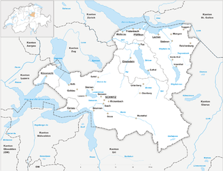
The canton of Schwyz is a canton in central Switzerland between the Alps in the south, Lake Lucerne to the west and Lake Zürich in the north, centred on and named after the town of Schwyz.

Valais ,,(German; Wallis) more formally the Canton of Valais/Canton of Wallis is one of the 26 cantons forming the Swiss Confederation. It is composed of thirteen districts and its capital and largest city is Sion. The flag of the canton is made of thirteen stars representing the districts, on a white-red background.
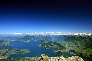
Lake Lucerne is a lake in central Switzerland and the fourth largest in the country.

The canton of Uri is one of the 26 cantons of Switzerland and a founding member of the Swiss Confederation. It is located in Central Switzerland. The canton's territory covers the valley of the Reuss between the St. Gotthard Pass and Lake Lucerne.

The canton of Zug or Zoug is one of the 26 cantons of Switzerland. It is located in central Switzerland and its capital is Zug. At 239 km2 (92 sq mi) the canton is one of the smallest of the Swiss cantons in terms of area. It is not subdivided into districts, but eleven municipalities.
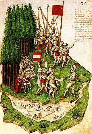
The Battle of Morgarten took place on 15 November 1315, when troops of Schwyz, supported by their allies of Uri and Unterwalden, ambushed an Austrian army under the command of Leopold I, Duke of Austria on the shores of Lake Ägeri, in the territory of Schwyz.

Obwalden or Obwald is one of the 26 cantons forming the Swiss Confederation. It is composed of seven municipalities and the seat of the government and parliament is in Sarnen. It is traditionally considered a "half-canton", the other half being Nidwalden.

Nidwalden or Nidwald is one of the 26 cantons forming the Swiss Confederation. It is composed of eleven municipalities and the seat of the government and parliament is in Stans. It is traditionally considered a "half-canton", the other half being Obwalden.
The Reuss is a river in Switzerland. With a length of 164 kilometres (102 mi) and a drainage basin of 3,426 square kilometres (1,323 sq mi), it is the fourth largest river in Switzerland. The upper Reuss forms the main valley of the canton of Uri. The course of the lower Reuss runs from Lake Lucerne to the confluence with the Aare at Brugg and Windisch.

There are 19 municipalities in the Canton of Uri in Switzerland.

The Old Swiss Confederacy began as a late medieval alliance between the communities of the valleys in the Central Alps, at the time part of the Holy Roman Empire, to facilitate the management of common interests such as free trade and to ensure the peace along the important trade routes through the mountains. The Hohenstaufen emperors had granted these valleys reichsfrei status in the early 13th century. As reichsfrei regions, the cantons of Uri, Schwyz, and Unterwalden were under the direct authority of the emperor without any intermediate liege lords and thus were largely autonomous.
The wars of Kappel (Kappelerkriege) is a collective term for two armed conflicts fought near Kappel am Albis between the Catholic and the Protestant cantons of the Old Swiss Confederacy during the Reformation in Switzerland.

The Gotthard Pass or St. Gotthard Pass at 2,106 m (6,909 ft) is a mountain pass in the Alps traversing the Saint-Gotthard Massif and connecting northern Switzerland with southern Switzerland. The pass lies between Airolo in the Italian-speaking canton of Ticino, and Andermatt in the German-speaking canton of Uri, and connects further Bellinzona and Lugano to Lucerne, Basel, and Zurich. The Gotthard Pass lies at the heart of the Gotthard, a major transport axis of Europe, and it is crossed by three traffic tunnels, each being the world's longest at the time of their construction: the Gotthard Rail Tunnel (1882), the Gotthard Road Tunnel (1980) and the Gotthard Base Tunnel (2016). With the Lötschberg to the west, the Gotthard is one of the two main north-south routes through the Swiss Alps.

The Bernese Oberland, the highest and southernmost part of the canton of Bern, is one of the canton's five administrative regions. It constitutes the Alpine region of the canton and the northern side of the Bernese Alps, including many of its highest peaks, among which the Finsteraarhorn, the highest in both range and canton.
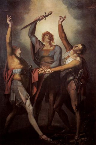
The Rütli Oath is the legendary oath taken at the foundation of the Old Swiss Confederacy by the representatives of the three founding cantons, Uri, Schwyz and Unterwalden, It is named after the site of the oath taking, the Rütli, a meadow above Lake Uri near Seelisberg. Recorded in Swiss historiography from the 15th century, the oath is notably featured in the 19th century play William Tell by Friedrich Schiller.

The Old Swiss Confederacy, also known as Switzerland, or the Swiss Confederacy was a loose confederation of independent small states, initially within the Holy Roman Empire. It is the precursor of the modern state of Switzerland.

The Dammastock is the highest mountain in the Urner Alps in Switzerland and is part of the Winterberg massif. Its summit ridge forms the border between the cantons of Uri and the Valais. It is the highest summit in the canton of Uri. The tripoint between the cantons of Berne, Valais and Uri lies near the Eggstock, north of the Dammastock. Politically, the Dammastock is split between the municipalities of Göschenen (Uri) and Obergoms (Valais).

The Axenstrasse is an 11.4-kilometre-long (7.1 mi) two-lane middle section with ongoing traffic between the A4 motorway and the A2 motorway, and part of European route E41 between the resort of Brunnen in the canton of Schwyz to the village of Flüelen in the canton of Uri in Central Switzerland. The road is built along steep cliffs on the east side of the Urnersee weaving through many rock fall galleries and tunnels along its route. Upon completion in 1865, the Axenstrasse was the first way to get to Uri that did not involve navigating Lake Lucerne.


