Because Cyprus has no working railway system, various other methods of transport are needed to ensure the proper delivery of any cargo, be it human or freight. Since the last railway was dismantled in 1952, the only remaining modes of transport are by road, by sea, and by air.

Nicosia is the largest city, capital, and seat of government of Cyprus. It is located near the centre of the Mesaoria plain, on the banks of the River Pedieos.

North Nicosia or Northern Nicosia is the capital and largest city of the de facto state of Northern Cyprus. It is the northern part of the divided city of Nicosia and is governed by the Nicosia Turkish Municipality. As of 2011, North Nicosia had a population of 61,378 and a metropolitan area with a population of 82,539.

The Eyalet of Cyprus was an eyalet (province) of the Ottoman Empire made up of the island of Cyprus, which was annexed into the Empire in 1571. The Ottomans changed the way they administered Cyprus multiple times. It was a sanjak (sub-province) of the Eyalet of the Archipelago from 1670 to 1703, and again from 1784 onwards; a fief of the Grand Vizier ; and again an eyalet for the short period from 1745 to 1748.

Aglandjia is a suburb and a municipality of Nicosia, Cyprus. The municipality has a population of 20,783 (2011) and is contiguous with Nicosia Municipality.

Ayios Dhometios is a suburb located west of the Cypriot capital Nicosia. It has a population of 12,456 making it one of Cyprus's biggest municipalities. There is also a population of 2,314 within the area of Ayios Dhometios under Turkish control.
Engomi is a suburb and municipality of the Cypriot capital Nicosia. In 2011, it had a population of 18,010. Of these, 14,254 were citizens of Cyprus.

Armenians in Cyprus or Armenian-Cypriots are ethnic Armenians who live in Cyprus. They are a recognized minority with their own language, schools and churches. Despite the relatively small number of Armenians living in Cyprus, the Armenian-Cypriot community has had a significant impact upon the Armenian diaspora and Armenian people. During the Middle Ages, Cyprus had an extensive connection with the Armenian Kingdom of Cilicia, while the Ganchvor monastery had an important presence in Famagusta. During the Ottoman Era, the Virgin Mary church and the Magaravank were very prominent. Certain Armenian-Cypriots were or are very prominent on a Panarmenian or international level and the fact that, for nearly half a century, the survivors of the Armenian Genocide have co-operated and co-existed peacefully with the Turkish-Cypriots is perhaps a unique phenomenon across the Armenian Diaspora. The emigration of a large number of Armenian-Cypriots to the United Kingdom has virtually shaped today's British-Armenian community.

The Cyprus Government Railway was a 2 ft 6 in narrow gauge railway network that operated in Cyprus from October 1905 to December 1951. With a total length of 76 miles (122 km), there were 39 stations, stops and halts, the most prominent of which served Famagusta, Prastio Mesaoria, Angastina, Trachoni, Nicosia, Kokkinotrimithia, Morphou, Kalo Chorio and Evrychou. The CGR was closed down due to financial reasons. An extension of the railway which was built to serve the Cyprus Mines Corporation operated until 1974.
Television in Cyprus was introduced in 1956. In 1957, CyBC was created. Private TV was introduced on 26 April 1992, by Logos TV which started its transmissions in stereo and Teletext from day one. The first private TV station of Cyprus was owned and operated by the Church of Cyprus. In August 1995, the same station introduced the first internet service provider in Cyprus, LOGOSNET. The Republic of Cyprus currently uses the PAL colour system and has converted terrestrial transmissions to digital on 1 July 2011, in line with EU policy. Because of the political division of the island, television companies are also divided.

Evrychou is a village in Cyprus. It is located in the Nicosia District and the agricultural centre of the "Solea" region located about 50 km south-west of Nicosia and 30 km from mount Troodos.

Agriculture in Cyprus constituted the backbone of its economy when it achieved its independence in 1960. It mostly consisted of small farms, and sometimes even subsistence farms. During the 1960s, irrigation projects made possible vegetable and fruit exports; increasingly commercialized farming was able to meet the demands for meat, dairy products, and wine from the British and United Nations troops stationed on the island and from the growing number of tourists.
Myrtou is a town in the Kyrenia District of Cyprus, north of the city of Morphou. It is under the de facto control of Northern Cyprus.

Agia Varvara is a town located in the Nicosia District of Cyprus. Agia is the Greek word for "Saint" .The town is named after Saint Varvara or Saint Barbara. The village is located 22 km south from Nicosia and is at an altitude of 311 meters. The town is known for its many cultivated and barren pieces of land. The town hosts the Church of Agia Varvara, the Chapel of Agia Paraskevi, Chapel of Agios Nektarios and the Chapel of Holy Cross.
Asha, also transliterated Assia, is a village in the Famagusta District of Cyprus, located 6 km northwest of Vatili. It is under the de facto control of Northern Cyprus.
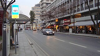
Makarios Avenue is an avenue in the centre of Nicosia, Cyprus which covers a distance of 2 kilometres (1.2 mi). The Street starts from the Junction of Evagoras Avenue until Aglandjia Avenue and is named after the first President of Cyprus Archbishop Makarios III. In Colonial times Makarios Avenue was named Pluto Street. and was the main route to Limassol, it was lined with residential buildings such as the Lyssiotis Mansion built in 1928 and is now the Head Office of the National Bank of Greece in Cyprus. The area has been transformed into a commercial district with many of the original buildings demolished to make way for shops and office blocks. Makariou Avenue is parallel to Stasikratous Street and Themistokli Dervi Avenue.
Arab Ahmet is a Neighbourhood, Quarter, Mahalla or Parish of Nicosia, Cyprus and the mosque situated therein. Both the Quarter and the mosque are named after Arab Ahmet Pasha, one of the Turkish commanders in the Ottoman conquest of Nicosia. It is spelled Arabahmet in Turkish and Άραπ Άχμετ in Greek.
Ayios Andreas or Tophane is a Neighbourhood, Quarter, Mahalla or Parish of Nicosia, Cyprus. In September 1945, the Ottoman name of Tophane was changed to Ayios Andreas, but there is no parish church of that name.

Köşklüçiftlik is a quarter of North Nicosia in Northern Cyprus. In 2011, it had a population of 2,939.

Nicosia within the city limits is divided into 29 administrative units, according to the latest census. This unit is termed in English as quarter, neighbourhood, parish, enoria or mahalla. These units are: Ayios Andreas, Trypiotis, Nebethane, Tabakhane, Phaneromeni, Ayios Savvas, Omerie, Ayios Antonios, St. John, Taht-el-kale, Chrysaliniotissa, Ayios Kassianos (Kafesli), Kaïmakli, Panayia, St Constantine & Helen, Ayioi Omoloyites, Arab Ahmet, Yeni Jami, Omorfita, Ibrahim Pasha, Mahmut Pasha, Abu Kavouk, St. Luke, Abdi Chavush, Iplik Pazar and Korkut Effendi, Ayia Sophia, Haydar Pasha, Karamanzade, and Yenişehir/Neapolis. Some of these units were previously independent Communities. Ayioi Omoloyites was annexed in 1944, while Kaïmakli and Omorfita were annexed in 1968. Pallouriotissa, also annexed in 1968, was subsequently divided into the neighbourhoods of Panayia, and St Constantine & Helen.
