North Rhine-Westphalia or North-Rhine/Westphalia, commonly shortened to NRW, is a state (Land) in Western Germany. With more than 18 million inhabitants, it is the most populous state in Germany. Apart from the city-states, it is also the most densely populated state in Germany. Covering an area of 34,084 square kilometres (13,160 sq mi), it is the fourth-largest German state by size.
Minden-Lübbecke is a Kreis (district) in the northeastern part of North Rhine-Westphalia, Germany. Neighboring districts are Diepholz, Nienburg, Schaumburg, Lippe, Herford, Osnabrück.

Herford is a Kreis (district) in the northeastern part of North Rhine-Westphalia, Germany. Neighboring districts are Minden-Lübbecke, Lippe, the urban district of Bielefeld and the districts of Gütersloh and Osnabrück.

The Sauerland is a rural, hilly area spreading across most of the south-eastern part of North Rhine-Westphalia, in parts heavily forested and, apart from the major valleys, sparsely inhabited.

Detmold is one of the five Regierungsbezirke of North Rhine-Westphalia, Germany, located in the north-east of the state. It is congruent with region of Ostwestfalen-Lippe.
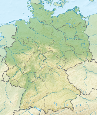
Germany is a country in Central and Western Europe that stretches from the Alps, across the North European Plain to the North Sea and the Baltic Sea. It is the second-most populous country in Europe after Russia, and is seventh-largest country by area in the continent. The area of Germany ranked 63rd and covers 357,021 km2 (137,847 sq mi), consisting of 349,223 km2 (134,836 sq mi) of land and 7,798 km2 (3,011 sq mi) of waters, smaller than Japan but larger than Republic of the Congo.

The Weser Depression or Weser Lowlands is the region north of Porta Westfalica in Germany, where the River Weser no longer flows through a valley, but a broad plain consisting of meadows and river terraces.

Osnabrück Land is a region in southwest Lower Saxony in Germany, which extends into the state of North Rhine-Westphalia. Its centre is the city of Osnabrück. The region is dominated by the Teutoburg Forest and the River Hase. Originally a variant of Low German was spoken here which belonged to the East-Westphalian dialect. The region is generally identified with the district and city of Osnabrück, which largely corresponds to the Prince-Bishopric of Osnabrück in the Holy Roman Empire. The Osnabrück Land Regional Association looks after cultural issues for the region.
Bruchbach may refer to various rivers and streams in Germany:
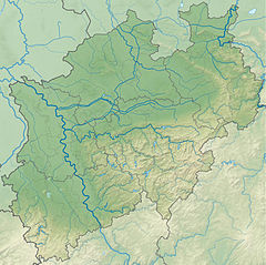
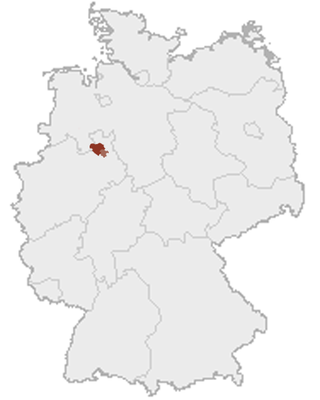
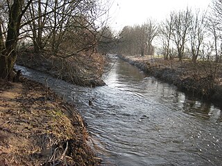
Bruchbach is a river of North Rhine-Westphalia, Germany. A right tributary of the Hessel, it flows for 8.3 kilometres and has a basin area of 19.139 km2. It flows into the Hessel in Oesterweg.
The Hessel is a river in Germany.
The Ravensberg Basin or Ravensberg Hills is a natural region in the governorate of Detmold in the northeastern part of the German state of North Rhine-Westphalia; small elements also fall within the neighbouring state of Lower Saxony. It is part of the lower Weser Uplands and includes the hilly basin country between the Wiehen Hills in the north, Lippe Uplands in the east, Teutoburg Forest in the south and Osnabrück Hills in the west. The heart of the Ravensberg Basin is almost coincident with the cultural region of the Ravensberg Land.
Kattenvenne is a village in Germany about 23 km northeast from Münster. It is part of the municipality Lienen.

Ravensberg Land is a cultural landscape in the district of Ostwestfalen-Lippe in the northeast of the German federal state of North Rhine-Westphalia. It lies between the Wiehen Hills to the north, the Teutoburg Forest to the south, the state border with Lower Saxony to the west and the large bend in the River Weser and the boundary of Lippe district to the east. It thus essentially encompasses the Westphalian part of the Ravensberg Hills. The most important towns are Bielefeld, Herford, Bad Oeynhausen and Bünde.
Aabach is a small river in the Ems river system, of North Rhine-Westphalia, Germany. It flows into the Hessel near Versmold.

Alte Emscher is a river of North Rhine-Westphalia, Germany. It is the former lower course of the Emscher. It flows into the Rhine near Hamborn (Duisburg).

Bowerre is a small river of North Rhine-Westphalia, Germany. It is a former branch of the river Werre in Herford.
Casumer Bach is a river of North Rhine-Westphalia, Germany. It is approximately 7.2 km long and flows directly into the Hessel east of Versmold.

Hardtbach is a river of North Rhine-Westphalia, Germany. It is a left tributary of the Rhine near Bonn.