
Pfäffikon is the principal town of the Municipality of Freienbach in the canton of Schwyz (SZ) in Switzerland. Together with Wollerau, Pfäffikon is considered the principal town of the district (Bezirk) of Höfe and the center of the region of Ausserschwyz. The former farm town is known today as cultural, economic and service center with its main focus on hedge funds. With 7,200 residents Pfäffikon is the third biggest town of the canton after Küssnacht and Einsiedeln.
Horgen District is a district of Canton of Zürich in Switzerland. The district is located in the Zimmerberg and Sihl Valley region; its capital is the town of Horgen. The district consists of 11 municipalities and has a population of 124,110 and an area of 104.16 km2 (40.22 sq mi).
Kreuzlingen District is one of the five districts of the canton of Thurgau in Switzerland. It has a population of 47,823. Its capital is the city of Kreuzlingen.
Altishausen is a village and former municipality in the canton of Thurgau, Switzerland.
Ellighausen is a village and former municipality in the canton of Thurgau, Switzerland.

Hugelshofen is a village and former municipality in the canton of Thurgau, Switzerland.
Lippoldswilen is a village and former municipality in the canton of Thurgau, Switzerland.

Neuwilen is a village and former municipality in the canton of Thurgau, Switzerland.
Siegershausen is a village and former municipality in the canton of Thurgau, Switzerland.

Bettwiesen Castle is a castle in the municipality of Bettwiesen of the Canton of Thurgau in Switzerland. It is a Swiss heritage site of national significance.
Hauptwil Castle is a castle in the municipality of Hauptwil-Gottshaus of the Canton of Thurgau in Switzerland. It is a Swiss heritage site of national significance.
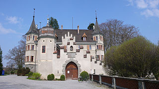
Seeburg Castle is a castle in the municipality of Kreuzlingen of the Canton of Thurgau in Switzerland. It is a Swiss heritage site of national significance.

Mammertshofen Castle is a castle in the municipality of Roggwil of the Canton of Thurgau in Switzerland. It is a Swiss heritage site of national significance.

Eugensberg Castle is a castle in the municipality of Salenstein of the Canton of Thurgau in Switzerland. It is a Swiss heritage site of national significance.

Louisenberg Castle is a castle in the municipality of Salenstein of the Canton of Thurgau in Switzerland. It is a Swiss heritage site of national significance.

Castell Castle is a castle in the municipality of Tägerwilen of the Canton of Thurgau in Switzerland. It is a Swiss heritage site of national significance.

Bachtobel Castle is a castle in the municipality of Weinfelden of the Canton of Thurgau in Switzerland. It is a Swiss heritage site of national significance.

Salenegg Castle is a castle in the municipality of Maienfeld of the Canton of Graubünden in Switzerland. It is a Swiss heritage site of national significance.


