Alumwell is a suburb on the west side of Walsall, in the West Midlands of England. The area is home to Walsall Manor Hospital. The neighbourhood is adjacent to the M6 and can be seen from the motorway by passing drivers. The neighbourhood is by a primary and secondary school. Most of the houses on the estate were built by the local authority during the 1950s.
In 2013, a national suburb census was taken in order to show faults and concerns In Alumwell so that areas could be developed. The census shown that 57% of residents were British, 41% were Asian and 2% other. The census shown areas of development such as crime, unemployment rate and street cleanliness. Crime was rated as 'Likely' in all three zones of Alumwell with Zone 2 resulting in the highest crime rate of the area. A ratio of 6:4 was shown that 60% of residents do not work and claim state benefits. This could also be to the high number of retired and young people on the area. And Street Cleanliness was rated as 'Poor' with comments such as concerns with graffiti, loitering and broken bus stop windows. Primley Avenue Park also went under inspection for drug use in 2013 which shown that drug use was clear to familiar to be taken place. This was reported.
In 2014, Alumwell underwent inspection again and was rated 3rd most deprived area in Walsall and 350 nationally.
Alumwell has a high quality of community workers such as neighbourhood watch which is shown effective in all three areas of Alumwell. The area is due to undergo a scheme in which roads will be redone, clearing of rubbish and the cleaning of graffiti.
Alumwell is home to four schools which run operational sporting activities for residents out of school time. Alumwell used to have three youth clubs located on Wolverhampton Road, Old Pleck Road and a Mobile youth club. All three were scrapped due to a lack of usage.
In 2011 it was estimated that the average number of children per household was 3. Which improved from 2006 where the average number of children per household was 5.
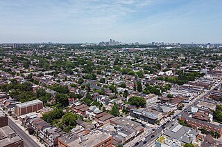
Regent Park is a neighbourhood located in downtown Toronto, Ontario built in the late 1940s as a public housing project managed by Toronto Community Housing. It sits on what used to be a significant part of the Cabbagetown neighbourhood and is bounded by Gerrard Street East to the north, River Street to the east, Shuter Street to the south and Parliament Street to the west. Regent Park's residential dwellings, prior to the ongoing redevelopment, were entirely social housing and covered all of the 69 acres (280,000 m2) which comprise the community. The original neighbourhood was razed in the process of creating Regent Park. The nickname Cabbagetown is now applied to the remaining historical, area north and west of the housing project, which has experienced considerable gentrification since the 1960s and 1970s.
Noble Park is a suburb in Melbourne, Victoria, Australia, 25 km south-east of Melbourne's Central Business District, located within the City of Greater Dandenong local government area. Noble Park recorded a population of 32,257 at the 2021 census.
Sutton is a small village and civil parish in the Peterborough district, in the north-west of Cambridgeshire, England. Situated about 5.7 miles from Peterborough and approximately half a mile south of the A47 road.
Dovercourt Park or Dovercourt Village is a neighbourhood in Toronto, Ontario, Canada situated north of Bloor Street between Christie Street to the east, the CPR railway lines to the north, and Dufferin Street to the west.
Yeoville is an inner city neighbourhood of Johannesburg, in the province of Gauteng, South Africa. It is located in Region F. Originally intended as a "well-to-do" neighbourhood, it instead developed into a white working class and lower middle class area as the city expanded northwards and public rail access improved. From the 1920s onwards it became a significant enclave of German Jewish and Eastern European Jewish immigrants. It was designated as a "white area" under the Group Areas Act during the apartheid era. It became a "grey area" in the 1980s, as a limited number of non-white residents began to rent in the area. From the end of the 1970s, a growing number of night clubs and galleries opened in Yeoville, or relocated from Hillbrow. This led to the neighbourhood becoming the leading nightspot in the city.The white population began to decline in the 1970s, and this white flight accelerated in the early to mid 1990s, with most residents migrating to the northern suburbs. Today, it is widely known and celebrated for its diverse, pan-African population but notorious for its high levels of crime, poverty and degradation.
Easton is an inner city area of the city of Bristol in the United Kingdom. Informally the area is considered to stretch east of Bristol city centre and the M32 motorway, centred on Lawrence Hill. Its southern and eastern borders are less defined, merging into St Philip's Marsh and Eastville. The area includes the Lawrence Hill and Barton Hill estates.
Ashley is an electoral ward in the city of Bristol, England. It is represented by three members on Bristol City Council, which as of 2024 are Abdul Malik, Izzy Russell and Tim Wye, all members of the Green Party of England and Wales.
Airds is a predominantly residential suburb of Campbelltown. Houses within the suburb are owned by Housing NSW. The land and houses are being sold off to a company and the area redeveloped to build private housing. Public Housing will only be about 30% of the area.
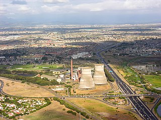
Athlone is a suburb of Cape Town located to the east of the city centre on the Cape Flats, south of the N2 highway. Two of the suburb's main landmarks are Athlone Stadium and the decommissioned coal-burning Athlone Power Station. Athlone is mainly residential and is served by a railway station of the same name. It however includes industrial and commercial zones. There are many "sub-areas" within Athlone, including Gatesville, Rylands, Belgravia Estate, Bridgetown and Hazendal. Colloquially other areas around Athlone are also often included in the greater Athlone area even though the City of Cape Town might classify them as separate neighborhoods such as Rondebosch East, Crawford, and Manenberg.
Palfrey is a neighbourhood in the Metropolitan Borough of Walsall, in the West Midlands. It covers 3.68 sq km, which accounts for 3.5% of the area of the Walsall borough.
Forest Lawn is a neighbourhood and former town in the southeast quadrant of the city of Calgary, Alberta, Canada. The neighbourhood is bound by 26 Avenue SE to the south, 36 Street SE to the west, 8 Avenue SE to the north and portions of 52 Street SE and 48 Street SE to the east. The former town comprises the entire current Forest Lawn neighbourhood as well as portions of Southview and Albert Park/Radisson Heights to the west, and portions of Penbrooke Meadows and Forest Lawn Industrial to the east. Both the neighbourhood and the former town are bisected by the multicultural 17 Avenue SE. Forest Lawn has an area redevelopment plan in place and is part of the International Avenue Business Revitalization Zone.
Woodbine is a residential neighbourhood in the southwest quadrant of Calgary, Alberta. It is located at the western edge of the city, and is bordered on the north by Anderson Road, on the west by Tsuut'ina Trail, on the east by 24th Street West, and to the south by Fish Creek Provincial Park.
Southwood is a residential neighbourhood in the southwest quadrant of Calgary, Alberta, Canada. It is bounded by 98th Avenue to the north, Macleod Trail to the east, Anderson Road to the south and 14th Street SW to the west. Southland Drive passes through the northern part of the community. A major roadway, Elbow Drive, bisects the community.
E-ACT West Walsall Academy is an 11–18 mixed secondary school and sixth form with academy status in Walsall, West Midlands, England.
Kenilworth is a suburb in Cape Town, South Africa.
Birch Cliff is a neighbourhood in Toronto, Ontario, Canada. It is located in the eastern part of the city, part of the district of Scarborough running along the shore of Lake Ontario atop the western part of the Scarborough Bluffs. Birch Cliff has a large Irish population. About one-third of Birch Cliff residents are of Irish origin.
Crime in Haiti is investigated by the Haitian police. Since the late 2010s, the country has suffered from widespread gang warfare and civil unrest, including a massive prison breakout in 2024. It also suffers from extreme corruption and high levels of sexual violence.
Park Beach is a suburb of Coffs Harbour, northern New South Wales, located in the north eastern part of the town. It has a population of around 5,000 which swells during summer as it is a coastal tourist destination containing many motels, backpackers and other forms of accommodation. The suburb of Park Beach is generally considered to be the area within the Ocean Parade and Orlando Street intersection at the south, the Orlando Street and Woolgoolga Road intersection, the turnoff from the Pacific Highway onto Macauleys Headland Drive, and the southern end of the Coffs Coast Regional Park.
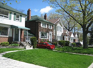
Wellington Crescent is an affluent neighbourhood in Winnipeg, Manitoba, Canada. It is known for its stately homes and for a small commercial area along Academy Road.
Behrman also known as "Behrman Heights", is a community located in Algiers, New Orleans It was named after popular New Orleans mayor Martin Behrman, and is nestled south of the US Naval Support neighborhood and north of Tall Timbers/Brechtel, flanked on the west by Fischer Housing Development and Whitney, and on the east by Old Aurora.
This page is based on this Wikipedia article Text is available under the CC BY-SA 4.0 license; additional terms may apply. Images, videos and audio are available under their respective licenses.