
Brown County is a county in the U.S. state of South Dakota. As of the 2020 census, the population was 38,301, making it the fourth most populous county in South Dakota. Its county seat is Aberdeen. The county is named for Alfred Brown, of Hutchinson County, South Dakota, a Dakota Territory legislator in 1879.

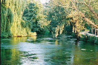
The River Avon is a river in the southwest of England. To distinguish it from a number of other rivers of the same name, it is often called the Bristol Avon. The name 'Avon' is loaned from an ancestor of the Welsh word afon, meaning 'river'.

Vorarlberg is the westernmost state of Austria. It has the second-smallest geographical area after Vienna and, although it also has the second-smallest population, it is the state with the second-highest population density. Two thirds of the state are situated above 1,000m. It borders three countries: Germany, Switzerland, and Liechtenstein. The only Austrian state that shares a border with Vorarlberg is Tyrol, to the east.

Bludenz is a town in the westernmost Austrian state of Vorarlberg with around 15.000 inhabitants. It is the administrative seat of the Bludenz District, which encompasses about half of Vorarlberg's territory.
The River Test is a chalk stream in Hampshire in the south of England. It rises at Ashe near Basingstoke and flows southwards for 40 miles (64 km) to Southampton Water. Settlements on the Test include the towns of Stockbridge and Romsey. The river's valley gives its name to the local government district of Test Valley. Below the village of Longparish, the river is broadly followed by the Test Way, a long-distance footpath.

The River Allen is a river in Dorset in South West England. It flows for 14 miles (23 km) to its confluence with the River Stour at Wimborne Minster. It has two main tributaries, the Gussage Stream and the Crichel Stream.

The Hutchinson River is a 10 mile-long (16 km) freshwater stream located in the New York City borough of the Bronx and Southern Westchester County, New York, United States. It forms on the New Rochelle–Scarsdale municipal line off Brookline Road in the latter community and flows south, draining a 19.4-square-mile (50 km2) area. It continues to serve as New Rochelle's city line with Eastchester; further downstream; its lower reaches divide Mount Vernon and Pelham until it enters the Bronx and empties into Long Island Sound's Eastchester Bay.

Esopus Creek is a 65.4-mile-long (105.3 km) tributary of the Hudson River that drains the east-central Catskill Mountains in the U.S. state of New York. From its source at Winnisook Lake on the slopes of Slide Mountain, the Catskills' highest peak, it flows across Ulster County to the Hudson at Saugerties. Many tributaries extend its watershed into neighboring Greene County and a small portion of Delaware County. Midway along its length, it is impounded at Olive Bridge to create Ashokan Reservoir, the first of several built in the Catskills as part of New York City's water supply system. Its own flow is supplemented 13 miles (21 km) above the reservoir by the Shandaken Tunnel, which carries water from the city's Schoharie Reservoir into the creek.
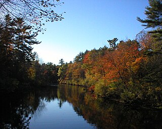
Ipswich River is a small river in northeastern Massachusetts, United States. It held significant importance in early colonial migrations inland from the ocean port of Ipswich. The river provided safe harborage at offshore Plum Island Sound to early Massachusetts subsistence farmers, who were also fishermen. A part of the river forms town boundaries and divides Essex County, Massachusetts on the coast from the more inland Middlesex County. It is 35 miles (56 km) long, and its watershed is approximately 155 square miles (401 km2), with an estimated population in the area of 160,000 people.

The Geroldsbach is a river of Tyrol, Austria.

The Meng is a river in Vorarlberg, Austria.

The Galina is a river of Vorarlberg, Austria.

The Alfenz is a river of Vorarlberg, Austria.

The Litz is a river of Vorarlberg, Austria.
Albiès is a commune in the Ariège department in the Occitanie region of southwestern France.
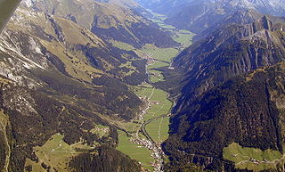
The Lechtal is an alpine valley in Austria, the greater part of which belongs to the state of Tyrol and the smaller part to Vorarlberg. The Lech river flows through the valley.
The Saw Kill is a 14.3-mile-long (23.0 km) tributary of the Hudson River, called the Metambesem by the Algonquin people of the area and sometimes called Sawkill Creek today. It rises in the town of Milan and drains a 22-square-mile (57 km2) area of northwestern Dutchess County, New York, that includes most of the town of Red Hook to the west and part of Rhinebeck to Red Hook's south.

The Brandnertal is a valley in the Austrian province of Vorarlberg as well as a ski resort named after the valley.

River Mease SSSI is a 23.0 hectares biological Site of Special Scientific Interest. It is a stretch of the River Mease and its tributary Gilwiskaw Brook, running between Alrewas in Staffordshire and Packington in Leicestershire. It is also a Special Area of Conservation The river goes through private land, but it is crossed by roads and footpaths.

Stoney Creek is a 2.76 mi (4.44 km) long second order tributary to the Delaware River in New Castle County, Delaware.

