Related Research Articles

The Papaloapan River is one of the main rivers of the Mexican state of Veracruz. Its name comes from the Nahuatl papaloapan meaning "river of the butterflies".

Coatzacoalcos is a major port city in the southern part of the Mexican state of Veracruz, mostly on the western side of the Coatzacoalcos River estuary, on the Bay of Campeche, on the southern Gulf of Mexico coast. The city serves as the municipal seat of the municipality of the same name. The city had a 2020 census population of 212,540, making it the third-largest city in the state after Veracruz and Xalapa. The municipality covers a surface area of 471.16 km2 (181.916 sq mi) and reported a population of 310,698 persons. The municipality population in 2015 was 319,187 a decrease of 9% over 2020.
Las Choapas is a city and its surrounding municipality in the southeastern extremes of the Mexican state of Veracruz. It is bordered by the municipalities of Uxpanapa, Minatitlán, Moloacán, and Agua Dulce in Veracruz, Huimanguillo in Tabasco, Cintalapa and Tecpatán in Chiapas, and Santa María Chimalapa in Oaxaca. Its major products are cattle breeding, corn, oil, fruit, sugar, and rubber. In the past it had a rice miller. It is one of the largest municipalities in Veracruz, with an area of 2,851.2 km². At the 2005 census the city had a population of 40,773 inhabitants, while the municipality had a population of 70,092. It is a very hot place, as temperature reaches up to 40 degrees Celsius. It has had some tornadoes in the past. It is connected to the communities of Raudales-Ocozocoautla in Chiapas through the Chiapas bridge.
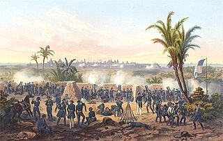
The Battle of Veracruz was a 20-day siege of the key Mexican beachhead seaport of Veracruz during the Mexican–American War. Lasting from March 9–29, 1847, it began with an amphibious assault conducted by United States military forces, and ended with the surrender and occupation of the city. U.S. forces then marched inland to Mexico City.

The Isthmus of Tehuantepec is an isthmus in Mexico. It represents the shortest distance between the Gulf of Mexico and the Pacific Ocean. Before the opening of the Panama Canal, it was a major overland transport route known simply as the Tehuantepec Route. The name is taken from the town of Santo Domingo Tehuantepec in the state of Oaxaca; this was derived from the Nahuatl term Tēcuāntepēc.
Omealca Municipality is a municipality in the Mexican state of Veracruz. The municipal seat is Omealca.

Cerro de las Mesas, meaning "hill of the altars" in Spanish, is an archaeological site in the Mexican state of Veracruz, in the Mixtequilla area of the Papaloapan River basin. It was a prominent regional center from 600 BCE to 900 CE, and a regional capital from 300 CE to 600 CE.

The Archdiocese of Xalapa is a Latin Church ecclesiastical territory or archdiocese of the Catholic Church in Mexico. Its episcopal see is Xalapa, Veracruz. A metropolitan see, its ecclesiastical province includes the suffragan dioceses of Coatzacoalcos, Córdoba, Orizaba, Papantla, San Andrés Tuxtla, Tuxpan and Veracruz.

The Sierra Madre de Oaxaca is a mountain range in southern Mexico. It is primarily in the state of Oaxaca, and extends north into the states of Puebla and Veracruz.

San Juan Bautista Tuxtepec, or simply referred to as Tuxtepec, is the head of the municipality by the same name and is the second most populous city of the Mexican state of Oaxaca. It is part of the Tuxtepec District of the Papaloapan Region. As of the 2020 census, the city is home to a population of 103,609 and 159,452 in the municipality, though census data are often under reported for various reasons.
Chacaltianguis is a municipality in the Mexican state of Veracruz. It is located in the south of the state of Veracruz. It has a surface of 557.69 km2. It is located at 18°18′N95°50′W.
José Azueta Municipality is a municipality in the Mexican state of Veracruz.
San Juan Evangelista is a municipality located in the plains of the Sotavento zone in the central zone of the Mexican state of Veracruz, about 260 km from the state capital Xalapa. It has a surface of 968.94 km2. It is located at 17°53′N95°08′W.
Soledad de Doblado is a municipality located in the semiarid zone of the center of the Mexican state of Veracruz, in the plains of the Sotavento of Veracruz, about 75 km from the state capital of Xalapa. It has a surface of 370.96 km2. It is located at 19°03′N96°25′W. On June 16, 1896, by Decree the town was named Soledad de Doblado, in honor of Manuel Doblado, who signed in this place, on February 19, 1862, the preliminary agreements with the representatives of England, Spain and France. By a decree of November 16, 1961 it rose to the category of city.
Tlacojalpan is a municipality in the Mexican state of Veracruz, about 175 km (109 mi) from the state capital Xalapa. It has a surface of 91.30 km2. It is located at 18°14′N95°57′W.

The Tonto River is a river of Oaxaca, Mexico that flows from the mountains of Zongolica. It is dammed by the Miguel Alemán Dam near the town of Temascal or Nuevo Soyaltepec, forming the Miguel Alemán Lake. Below the dam, the river flows southeast past San Juan Bautista Tuxtepec, where it joins the Santo Domingo River to form the Papaloapan River.
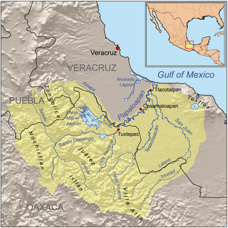
The San Juan River is a river of Veracruz state in eastern Mexico. It is a tributary of the Papaloapan River.
The Lalana River is a river of Oaxaca and Veracruz states of Mexico.
The SS Las Choapas was an oil tanker built in 1898. She was originally commissioned by Standard Oil of New Jersey and built by the Delaware River Iron Ship Building and Engine Works of Chester, PA. As the SS Atlas she saw service in World War I before being sold in the 1920s to the Italian company Ditta G.M. Barbagelata, of Genoa.
The Clausura 2016 Copa MX was the 75th staging of the Copa MX, the 48th staging in the professional era and is the eighth tournament played since the 1996–97 edition.
References
- "Atlas of Mexico – River Basins (Map from book)". lib.utexas.edu. 1975. Archived from the original on 2011-11-07.
- The Prentice Hall American World Atlas, 1984.
- Rand McNally, The New International Atlas, 1993.
18°15′30″N96°17′14″W / 18.25833°N 96.28722°W
| | This article related to a river in Mexico is a stub. You can help Wikipedia by expanding it. |