
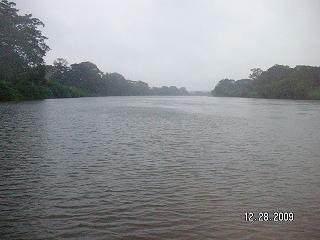
The Papaloapan River is one of the main rivers of the Mexican state of Veracruz. Its name comes from the Nahuatl papaloapan meaning "river of the butterflies".
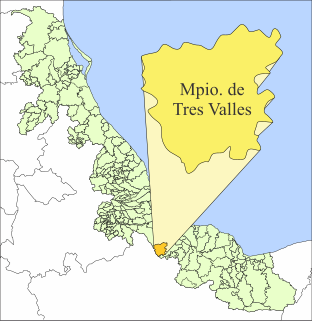
Tres Valles is a town and municipality in the Mexican state of Veracruz, created as a free municipality by decree on November 25, 1988. It is located in the lower reaches of the Papaloapan, and borders the state of Oaxaca and the towns of Tierra Blanca and Cosamaloapan.

Miguel Alemán Valdés was a Mexican politician who served a full term as the President of Mexico from 1946 to 1952, the first civilian president after a string of revolutionary generals. His administration was characterized by Mexico's rapid industrialization, often called the Mexican Miracle, but also for a high level of personal enrichment for himself and his associates. His presidency was the first of a new generation of Mexican leaders, who had not directly participated in the Mexican Revolution, and many in his cabinet were also young, university-educated civilians.

San Juan Bautista Tuxtepec, or simply referred to as Tuxtepec, is the head of the municipality by the same name and is the second most populous city of the Mexican state of Oaxaca. It is part of the Tuxtepec District of the Papaloapan Region. As of the 2005 census, the city is home to a population of 94,209 and 144,555 in the municipality, though census data are often under reported for various reasons. The municipality resides in the region called La Cuenca, is located 36 feet above sea level, and occupies an area of approximately 580 square miles (1,500 km2). The city itself is surrounded by the Papaloapan River, and lies a few kilometers south of the Cerro de Oro Dam on its tributary the Santo Domingo River. The municipality is bordered by the state of Veracruz in the north, the municipalities of Loma Bonita to the east and San José Chiltepec to the south. It is almost 100 miles (160 km) to the port of Veracruz, 130 miles (210 km) to Oaxaca City, the state capital, and 310 miles (500 km) to Mexico City.

Temascal is a town in the Mexican state of Oaxaca which is the seat of the municipality of San Miguel Soyaltepec. It is part of the Tuxtepec District of the Papaloapan Region. The name Soyaltepec means "hill of palm trees" in Náhuatl but the area also carries the Mazatec name of Naxhingee which means “ragged hill”.
San Juan Bautista Valle Nacional is a town and municipality in Oaxaca in south-western Mexico. The municipality covers an area of 394.23 km² within the Sierra Juárez mountains. It is part of the Tuxtepec District of the Papaloapan Region. The town lies on the north bank of the Valle Nacional River, a tributary of the Papaloapan River.
San Juan Evangelista is a municipality located in the plains of the Sotavento zone in the central zone of the State of Veracruz, about 260 km from state capital Xalapa. It has a surface of 968.94 km2. It is located at 17°53′N95°08′W.

Tezonapa is a municipality located in the high mountains region in the State of Veracruz, Mexico, about 219 km from state capital Xalapa. It has a surface of 351 km2. It is located at 18°36′N96°41′W. The law number 93 of December 22, 1960 San Agustín created Tezonapa's municipality with the congregations of the Josefinas, Prison, Tezonapa, Palmarito, etc.
Tlacojalpan is a municipality located in the south zone in the State of Veracruz, Mexico, about 175 km (109 mi) from state capital Xalapa. It has a surface of 91.30 km2. It is located at 18°14′N95°57′W. The name comes from the language Náhuatl, Tlahco-xal-pan; that means “In the half of the sandbank".
The Valle Nacional River is a river of Oaxaca state in Mexico. The river originates in the Sierra Juárez, Oaxaca. The ecology of the region, originally one of pine forests, is threatened by logging, agriculture and grazing. The Valle Nacional flows past San Juan Bautista Valle Nacional, and joins the Santo Domingo River to the southwest of San Juan Bautista Tuxtepec to form the Papaloapan River.
Lake Miguel Alemán is in the Papaloapan Region of northern Oaxaca state, Mexico. It was formed by the Miguel Alemán Dam, and is connected by a channel to the reservoir of the Cerro de Oro Dam. The lake is scenic, providing income from fishing and tourism. The northwestern shore and islands have been declared a nature reserve. Commercial fisheries produce approximately 700 tons per year. The hilltops in the area covered by the lake are now the San Miguel Soyaltepec and Isabel Maria Islands. The reservoir contains catfish, tilapia, and carp and other types of fish. Tourist activities include sport fishing, water skiing, rowing and boat tours provided by the local fishermen. Important boat races are sometimes held in May.
El Corte River is the primary tributary of the Coatzacoalcos River, flowing through the Mexican states of Oaxaca and Veracruz to the Gulf of Mexico.
The Cerro de Oro Dam, also called the Miguel de la Madrid Hurtado Dam, is on the Santo Domingo River in the San Juan Bautista Tuxtepec municipality of the Papaloapan Region of Oaxaca state in southern Mexico. The dam operates in conjunction with the Miguel Alemán Dam, located on the Tonto River to control floods in the Papaloapan basin in Veracruz state. Construction began in 1973 and the dam was completed in May 1989. About 26,000 people were displaced by the project. Water quality in the reservoir is poor and deteriorating, affecting fish catches.
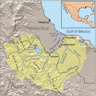
The Santo Domingo River in Oaxaca state, Mexico is one of the main tributaries of the Papaloapan River, rising in the Sierra Madre de Oaxaca and flowing east towards San Juan Bautista Tuxtepec, above which it joins with the Valle Nacional River to form the Papaloapan. Carrying sediment from the mountains, it was a major cause of flooding in the coastal plain of Veracruz by reducing the capacity of the Papaloapan to drain the plains. To alleviate these problems, the Cerro de Oro Dam was constructed on the river just above the junction with the Valle Nacional, completed in 1989. The dam extended the reservoir formed by the Miguel Alemán Dam, located on the Tonto River.

The Miguel Alemán Dam is on the Tonto River in the Papaloapan Region of Oaxaca state in southern Mexico, just upstream from the town of Temascal or Nuevo Soyaltepec, forming the Miguel Alemán Lake with an area of 47,800 hectares. The dam operates in conjunction with the Cerro de Oro Dam, located on the Santo Domingo River to control floods in the Papaloapan basin in Veracruz state. Together with the 22,000 hectare reservoir of the Cerro de Oro, which is joined by a channel to the Miguel Alemán Lake, the combined capacity is 13,380 million cubic metres. The lake formed by the dam is scenic, providing income from fishing and tourism. The northwestern shore and islands have been declared a nature reserve. The dam includes the Temascal hydroelectric plant.

The Sierra Juárez is a range of mountains in Oaxaca state, Mexico between latitudes 17°20'-17°50'N and longitudes 96°15'-97°00'W, with an area of about 1,700 km². It is part of the Sierra Madre de Oaxaca. The range is separated from the Sierra de Zongólica to the north by the Santo Domingo River, flowing through the Tecomavaca Canyon. It stretches south-eastward to the Cajones River and the Sierra de Villa Alta. The mountains are in the district of Ixtlán de Juárez in the Sierra Norte de Oaxaca region. The range is named after Mexico's only indigenous president, Benito Juárez, who was born here in 1806 in the small village of San Pablo Guelatao. The heavily wooded area is about 62 km (39 mi) from the city of Oaxaca on Federal highway 175, heading towards Tuxtepec.
The Cajones River, in the Ayotzintepec municipality, divides the Sierra Juárez, Oaxaca from the Sierra de Villa Alta in Oaxaca state, Mexico. It joins the Manso River to form the Tesechoacan River, a tributary of the Papaloapan River.

The Cuenca del Papaloapan Region is in the north of the state of Oaxaca, Mexico where the foothills of the Sierra Madre de Oaxaca meet the coastal plain of Veracruz. The principal city is San Juan Bautista Tuxtepec, the second largest in Oaxaca state.
Tuxtepec District is located in the north of the Papaloapan Region of the State of Oaxaca, Mexico.
The Sierra Mazateca is a mountainous area, part of the Sierra Madre de Oaxaca mountain range, located in the northern part of the state of Oaxaca in Southern Mexico. It is named after the Mazatec people, who are indigenous to the area.


