Related Research Articles

The history of Crete goes back to the 7th millennium BC, preceding the ancient Minoan civilization by more than four millennia. The Minoan civilization was the first civilization in Europe.
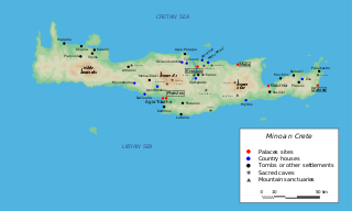
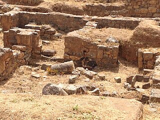
Phaistos, also transliterated as Phaestos, Festos and Latin Phaestus, is a Bronze Age archaeological site at modern Faistos, a municipality in south central Crete. It is notable for the remains of a Minoan palace and the surrounding town.
In Greek mythology, two sacred mountains are called Mount Ida, the "Mountain of the Goddess": Mount Ida in Crete, and Mount Ida in the ancient Troad region of western Anatolia, which was also known as the Phrygian Ida in classical antiquity and is mentioned in the Iliad of Homer and the Aeneid of Virgil. Both are associated with the mother goddess in the deepest layers of pre-Greek myth, in that Mount Ida in Anatolia was sacred to Cybele, who is sometimes called Mater Idaea, while Rhea, often identified with Cybele, put the infant Zeus to nurse with Amaltheia at Mount Ida in Crete. Thereafter, his birthplace was sacred to Zeus, the king and father of Greek gods and goddesses.
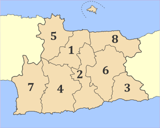
Heraklion is one of the four regional units of Crete. The capital is the city of Heraklion.
Kamares is a village in south-central Crete, Greece. It is the location of an archaeological site of a Minoan sacred cave. The sacred cave at Kamares is slightly offset from a saddle in the Psiloriti Range virtually aligned with the location of nearby Phaistos. Some of the best examples of Middle Minoan pottery have been recovered from the Kamares cave. Kamares has provided the type name for Kamares ware, a ceramic type dating from MM IA, or the First Palace Period. This pottery is a light-on-dark polychrome ware, with forms including jugs and cups.

John Devitt Stringfellow Pendlebury was a British archaeologist who worked for British intelligence during World War II. He was captured and summarily executed by German troops during the Battle of Crete.

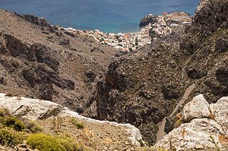
Monastiraki is the archaeological site of an ancient Minoan town on the island of Crete. The site is on the plain of Amari, west of the Ida massif, 38 kilometres from Rethymnon.

Kydonia, also known as Cydonia was an ancient city located at the site of present-day Chania on the island of Crete in Greece. The city is known from archaeological remains dating back to the Minoan era as well as literary and historical sources.
Lato pros Kamara or simply Kamara or Camara was an ancient city of Crete, situated to the east of Olous, according to the Maritime Itinerary at a distance of 15 stadia. It is currently the site of Agios Nikolaos, Crete. Lato pros Kamara was settled in the late Bronze Age as the population of Dorian Lato realised greater security. Its expanding population settled the coastal area, which had been subject to greater likelihood of marine attack during the earlier Bronze Age. Xenion, a Cretan historian quoted by Stephanus of Byzantium says that it was once called "Lato", however, modern scholarship distinguishes the two, placing Lato pros Kamara as the port of Lato. Lato pros Kamara outlasted Lato well into Roman times.

Friedrich-Wilhelm Müller was a general in the Wehrmacht of Nazi Germany during World War II. He led an infantry regiment in the early stages of the war and by 1943 was commander of the 22nd Air Landing Division. Under his orders, troops of the division committed atrocities against Greek civilians. He was later commander of occupied Crete and his harsh methods of controlling the island saw him nicknamed "The Butcher of Crete." After the war he was convicted and executed by a Greek court for war crimes.
Kalyvia is a village in the Heraklion regional unit on southern Crete in Greece. The local area was important in the Minoan era, as manifested by the extensive ruins of nearby Phaistos, a major palatial settlement of the Bronze Age.
The Asterousia Mountains are a range in southern Crete separating the Messara Plain from the Libyan Sea. Evidence of ancient Cretan cultures have been found in excavations performed within sites contained in this range; moreover, one of the most significant Minoan sites on Crete has been excavated at nearby Phaistos to the north; apparently, the Phaistos palace was designed to permit views over the expansive Messara Plain and the Asterousi Mountains. A further historical name for this range is reported by Encyclopædia Britannica as the Kofinos Range, named after the highest peak of Asteroussia, Kofinas.

The Libyan Sea is the portion of the Mediterranean Sea north of the African coast of ancient Libya, i.e. Cyrenaica, and Marmarica.
A processional walkway is a ceremonial walkway in use since ancient times. Common functions of a processional walkway are for religious, governmental or celebratory purposes.
The Holocaust of Kedros, also known as the Holocaust of Amari, was the mass murder of the civilian residents of nine villages located in the Amari Valley on the Greek island of Crete during its occupation by the Axis powers in World War II. The massacre was a reprisal operation mounted by Nazi German forces.

Mount Kedros, is a mountain on the island of Crete in Greece. It is located southwest of the Ida massif with which it forms the two flanks of the Amari Valley. Mount Kedros is conical-shaped and made of limestone. Its landscape abounds with canyons and rock cliffs and is almost barren, with dry scrubs and phrygana being the major forms of vegetation. Kedros grows endemic or rare flowers such as tulips, anemones, corn marigolds, turban buttercups, tassel hyacinths, orchids, etc., and provides ideal conditions for the nesting of falcons as well as larger birds of prey such as griffon vultures, golden eagles and Bonelli's eagles. Owing to the significance of its flora and fauna, Mount Kedros is a node of the Natura 2000 network of protected areas. An E4 mountain footpath climbs up to the highest peak of the site. To the north of Kedros are located the plateau Gious Kampos and the Kissano gorge.

Amari is a village and a municipality in Rethymno regional unit, Crete, Greece. The seat of the municipality is the village Agia Foteini. The municipal unit has an area of 277.285 km2 (107.060 sq mi). One of the major geographic features of Amari is the Amari Valley, a landform of high elevation known for olive cultivation. It is thought that Monastiraki was developed by Phaistos inhabitants founding a satellite center as they pushed out into the Amari Valley.

Gious Kampos, is a plateau in the Amari Valley on the island of Crete in Greece. Its name comes from the phrase "τση Γιούς ο Κάμπος", which means the plain of Eos in the Cretan dialect. Located northwest of Mt. Kedros, the plateau extends to an area of approx. 2.5 km2 and lies at an average altitude of 750 m, having good road access from the villages of Spili, Kissos and Gerakari. The plateau is well known for its remarkably rich flora which includes several native and endemic plants. In particular, the red Tulipa doerfleri, one of the few native species of tulips in Crete, thrives there. The plateau also grows high-quality cereals and arid vegetables.

Georgios Petrakis, better known as Petrakogiorgis, was a Greek businessman, partisan, and politician. He was a leading figure in the Cretan resistance of the years 1941 – 1944 against the Axis occupation forces, well respected for his patriotism, courage, honesty, perspicacity and selflessness.
The Battle of Trahili was fought on 15 August 1943 between Cretan partisans and German occupying forces during World War II. It took place near the village of Vorizia in south-central Crete, when German forces attempted to surround a small group of partisans led by the local chieftain Petrakogiorgis. Most of the partisans managed to escape, despite being heavily outnumbered.
References
- C. Michael Hogan. 2007. C.Michael Hogan, Phaistos Fieldnotes, The Modern Antiquarian
- John D. Pendlebury. 1991. The Archaeology of Crete, Biblo & Tannen Publishers, ISBN 0-8196-0121-7, ISBN 978-0-8196-0121-6