Weldiya is the capital of the Semien Wollo Zone, and woreda in northern Ethiopia. Located north of Dessie and southeast of Lalibela in the Amhara Region, this town has an elevation of 2112 meters above sea level.

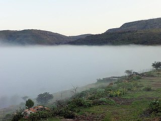
Ankober, formerly known as Ankobar, is a town in central Ethiopia. Located in the Semien Shewa Zone of the Amhara Region, Ankober is perched on the eastern escarpment of the Ethiopian Highlands at an elevation of about 2,465 meters (8,100 ft). It is 40 kilometers (25 mi) to the east of Debre Birhan and about 90 miles (140 km) northeast of Addis Ababa.
Amba Mariam is a village in central Ethiopia. It was known as Magdala or Makdala during the reign of Emperor Tewodros II of Ethiopia (1855-1869). Located in the Debub Wollo Zone of the Amhara Region, Amba Mariam has a longitude and latitude of 11°12′N39°17′E.

Kombolcha is a city and woreda in north-central Ethiopia. Located in the Debub Wollo Zone of the Amhara Region, it has a latitude and longitude of 11°5′N39°44′E with an elevation between 1842 and 1915 meters above sea level. Some guide books describe Kombolcha as the twin city of Dessie which lies some 13 km to the northwest.
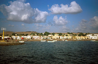
Tadjoura is one of the oldest town in Djibouti and the capital of the Tadjourah Region. The town evolved into an early Islamic center with the arrival of Muslims shortly after the hegira. An important port for many centuries, it was ruled by a succession of polities, including the Ifat Sultanate, Adal Sultanate, the Ottoman Empire, France until Djibouti's independence in 1977. Lying on the Gulf of Tadjoura, it is home to a population of around 45,000 inhabitants. It is the third largest city in the country after Djibouti City and Ali Sabieh.
Kidane Kale, better known as Abuye, was a Meridazmach of Shewa, an important Amhara noble of Ethiopia. He was the son of Sebestyanos. Abir states that he ruled for 25 years, although noting that Harris claims he ruled for 15 years, Coulbeaux for 25, and d'Hericourt for 60. His wife was Woizero Tagunestiya, daughter of Mama Rufa'el, Governor of Mamameder.
Menz or Manz is a former province of Ethiopia, located inside the boundaries of the modern Semien Shewa Zone of the Amhara Region. William Cornwallis Harris described Menz as lying "westward" of Gedem but between that former province and Marra Biete.
Were Babu is one of the woredas in the Amhara Region of Ethiopia. This woreda is named for one of the "Houses" or subgroups of the Wollo Amhara that used to govern the area and is still located there. Part of the Debub Wollo Zone, Were Babu is bordered on the south by Kalu, on the west by Tehuledere, on the north by the Mille River which separates it from the Semien Wollo Zone, on the east by the Afar Region, and on the southeast by the Mio River which separates it from the Oromia Zone. The administrative center of Were Babu is Bistma; other towns include Arabati and Bokeksa.
Moretna Jiru is one of the woredas in the Amhara Region of Ethiopia. It is named in part after the historic district of Shewa, Moret, which lay between the Jamma River and the district of Shewa Meda. Part of the Semien Shewa Zone, Moretna Jiru is bordered on the south by Siyadebrina Wayu, on the south west by Ensaro, on the northwest by Merhabiete, on the northeast by Menz Keya Gebreal, and on the east by Basona Werana. The administrative center of this woreda is Enewari; other towns in Moretna Jiru include Jihur.
Menjarna Shenkora is one of the woredas in the Amhara Region of Ethiopia. It is named in part after a historic district of Shewa, Menjar, which was the southernmost district of Shewa and near the location of the modern woreda. Located at the southern end of the Semien Shewa Zone, Menjarna Shenkora is bordered on the east, south and west by the Oromia Region, on the northwest by Hagere Mariamna Kesem, and on the northeast by Berehet; the Germama river forms the boundary between this woreda and Hagere Mariamna Kesem and Berehet. The administrative center of this woreda is Arerti; other towns in the woreda include Balchi and Eranbuti.
Meta Robi is one of the woredas in the Oromia Region of Ethiopia. Part of the West Shewa Zone, it is bordered on the south by Ejerie, on the southwest by Jeldu, on the northwest by Ginde Beret, on the north by the Muger River, and on the east by Adda Berga. The major town in Meta Robi is Sheno.

The Jamma River is a river in central Ethiopia and a tributary of the Abay on its right side. It drains parts of the Semien Shewa Zones of the Amhara and Oromia Regions. The Upper Jamma flows through steep, deep canyons cut first through volcanic rock and then through the Cretaceous sandstone and shaly sandstone, with Jurassic limestone at the bottom. It has a drainage area of about 15,782 square kilometers in size. Tributaries include the Wanchet.
Sela Dingay is a town in central Ethiopia. In Amharic the name means the sharpened stone, named for a rock which rolled over the edge of the southern rim of the gorge of the Mofar River, and killed a group of people sitting on it. Located in the Semien Shewa Zone of the Amhara Region, this town has a latitude and longitude of 09°58′N39°38′E with elevations variously given as 2880 and 2915 meters above sea level. It is the administrative center of Mojana Wadera woreda.
Tenta is a town in northern Ethiopia. Located in the Debub Wollo Zone of the Amhara Region, Tenta has a latitude and longitude of 11°19′N39°15′E with an elevation of 2972 meters above sea level. It is one of three towns in Tenta woreda.
Mulu is a town in eastern Ethiopia, located in the Western Zone of the Somali Region. It is one of Nine woreda in Mieso woreda. Mulu is served by a station on the Addis Ababa-Djibouti railroad.
Borkana River is a river of central Ethiopia. A tributary of the Awash on the left side, the Borkana joins its parent stream at 10°37′N40°30′E. Johann Ludwig Krapf records that it was called "Tshaffa" by the local Oromo people.
Ancharo is a town in northern Ethiopia. Located in the Debub Wollo Zone of the Amhara Region, Ancharo has a latitude and longitude of 11°03′N39°47′E with an elevation of 2972 meters above sea level. It is one of four towns in Kalu woreda.
Karl Wilhelm Isenberg, spelt or known by names Carl Wilhelm Isenberg or Charles William Isenberg or C. W. Isenberg or Carl W. Isenberg or Charles Isenberg, was a German Church Missionary Society missionary and linguist to East Africa and Western India.