Amchitka Pass

Last updated

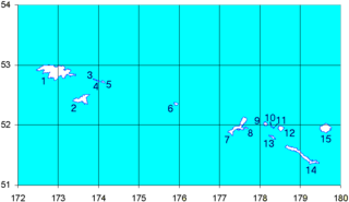
Amchitka Pass is a strait in Alaska, United States. It is located in the Aleutian Islands on the 180th meridian, between the Rat Islands group to the west and the Delarof Islands to the east. Amchitka Pass has a least width of 50 miles (80.5 km) and depths of 249 feet (76 meters) to over 6,000 feet (1,829 meters). The islands on both sides of the pass should be cleared by at least 5 miles (8 km). Heavy tide rips have been observed off the east end of Amchitka Island. The pass is dangerous in heavy weather, particularly for small and medium craft; currents appear erratic in direction and velocities may be strong. This may account for reports of very large seas and strong tide rips. [1]

Alaska State of the United States of America

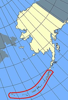
Alaska is a U.S. state in the northwest extremity of North America, just across the Bering Strait from Asia. The Canadian province of British Columbia and territory of Yukon border the state to the east, its most extreme western part is Attu Island, and it has a maritime border with Russia to the west across the Bering Strait. To the north are the Chukchi and Beaufort seas—southern parts of the Arctic Ocean. The Pacific Ocean lies to the south and southwest. It is the largest state in the United States by area and the seventh largest subnational division in the world. In addition, it is the 3rd least populous and the most sparsely populated of the 50 United States; nevertheless, it is by far the most populous territory located mostly north of the 60th parallel in North America: its population—estimated at 738,432 by the United States Census Bureau in 2015— is more than quadruple the combined populations of Northern Canada and Greenland. Approximately half of Alaska's residents live within the Anchorage metropolitan area. Alaska's economy is dominated by the fishing, natural gas, and oil industries, resources which it has in abundance. Military bases and tourism are also a significant part of the economy.

United States federal republic in North America

The United States of America (USA), commonly known as the United States or America, is a country composed of 50 states, a federal district, five major self-governing territories, and various possessions. At 3.8 million square miles, the United States is the world's third or fourth largest country by total area and is slightly smaller than the entire continent of Europe's 3.9 million square miles. With a population of over 327 million people, the U.S. is the third most populous country. The capital is Washington, D.C., and the largest city by population is New York City. Forty-eight states and the capital's federal district are contiguous in North America between Canada and Mexico. The State of Alaska is in the northwest corner of North America, bordered by Canada to the east and across the Bering Strait from Russia to the west. The State of Hawaii is an archipelago in the mid-Pacific Ocean. The U.S. territories are scattered about the Pacific Ocean and the Caribbean Sea, stretching across nine official time zones. The extremely diverse geography, climate, and wildlife of the United States make it one of the world's 17 megadiverse countries.

Aleutian Islands chain of islands in the Northern Pacific

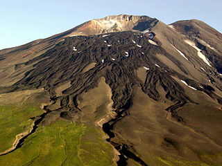
The Aleutian Islands, also called the Aleut Islands or Aleutic Islands and known before 1867 as the Catherine Archipelago, are a chain of 14 large volcanic islands and 55 smaller ones belonging to both the U.S. state of Alaska and the Russian federal subject of Kamchatka Krai. They form part of the Aleutian Arc in the Northern Pacific Ocean, occupying an area of 6,821 sq mi (17,666 km2) and extending about 1,200 mi (1,900 km) westward from the Alaska Peninsula toward the Kamchatka Peninsula in Russia, and mark a dividing line between the Bering Sea to the north and the Pacific Ocean to the south. Crossing longitude 180°, at which point east and west longitude end, the archipelago contains both the westernmost part of the United States by longitude and the easternmost by longitude. The westernmost U.S. island in real terms, however, is Attu Island, west of which runs the International Date Line. While nearly all the archipelago is part of Alaska and is usually considered as being in the "Alaskan Bush", at the extreme western end, the small, geologically related Commander Islands belong to Russia.

Related Research Articles

Aleutians West Census Area, Alaska Census area in the United States

Aleutians West Census Area is a census area located in the U.S. state of Alaska. As of the 2010 census, the population was 5,561. It is part of the Unorganized Borough and therefore has no borough seat. Its largest city is Unalaska. It contains most of the Aleutian Islands, from Attu Island in the west to Unalaska Island in the east, as well as the Pribilof Islands, which lie north of the Aleutians in the Bering Sea.

Sand Point, Alaska City in Alaska, United States

Sand Point, also known as Qagun Tayagungin, is a city in Aleutians East Borough, Alaska, United States. At the 2010 census the population was 976, up from 952 in 2000. It is on northwestern Popof Island, one of the Shumagin Islands, off the Alaska Peninsula. It is the borough seat of Aleutians East Borough, and is near the entrance to the Bering Sea.

Unimak Island island in the United States of America

Unimak Island is the largest island in the Aleutian Islands chain of the U.S. state of Alaska.

Amchitka island in the United States of America

Amchitka is a volcanic, tectonically unstable island in the Rat Islands group of the Aleutian Islands in southwest Alaska. It is part of the Alaska Maritime National Wildlife Refuge. The island, with a land area of roughly 116 square miles (300 km2), is about 42 miles (68 km) long and 1 to 4 miles wide. The area has a maritime climate, with many storms, and mostly overcast skies.

Andreanof Islands group of islands in the Aleutian Islands

The Andreanof Islands are a group of islands in the Aleutian Islands, in southwestern Alaska. They are located at about 52° North and 172°57' to 179°09' West.

Rat Islands island group

The Rat Islands are a volcanic group of islands in the Aleutian Islands in southwest Alaska, between Buldir Island and the Near Islands group to its west, and Amchitka Pass and the Andreanof Islands group to its east, at about 51°47′17″N178°18′10″E.

Shemya island in the United States of America

Shemya or Simiya is a small island in the Semichi Islands group of the Near Islands chain in the Aleutian Islands archipelago southwest of Alaska, at 52°43′27″N174°07′08″E. It has a land area of 5.903 sq mi (15.29 km2), and is about 1,200 miles (1,900 km) southwest of Anchorage, Alaska. It is 2.73 miles (4.39 km) wide and 4.32 miles (6.95 km) long.

Buldir Island island in the United States of America

Buldir Island is a small island in the western Aleutian Islands of the U.S. state of Alaska. It lies midway between the Near Islands in the West and the Rat Islands in the East. It is the most westerly of the Aleutian Islands which formed as a result of volcanic activity in the late Quaternary or Recent times. The rocks from which the island formed are of two different ages with a considerable time gap. The rocks of the older dome are mainly olivine basalts and the younger dome consists of hornblende basalts and basaltic andesites. That this island is younger than some of the neighboring islands is also suggested by the fact that there are fewer species of flowering plant on this island.

Little Sitkin Island volcanic island in the Aleutian Islands, Alaska, United States

Little Sitkin Island is a volcanic island in the Rat Islands archipelago of the Western Aleutian Islands, Alaska, about 3 miles (4.8 km) east of Davidof Island. Great Sitkin Island lies 185 miles (298 km) further east in the Andreanof Islands.

Delarof Islands island group

The Delarof Islands are a group of small islands at the extreme western end of the Andreanof Islands group in the central Aleutian Islands, Alaska. The Delarofs consist of 11 named islands: Amatignak, Gareloi, Ilak, Kavalga (Qavalĝa), Ogliuga (Aglaga), Skagul (Sxaĝulax̂), the Tags (Tagachaluĝis), Tanadak (Tanaadax̂), Ugidak (Qagan-tanax̂), Ulak, and Unalga (Unalĝa).

Gareloi Island island in the United States of America

Gareloi or Anangusook is a volcanic island in the Delarof Islands of the Aleutian Islands of Alaska. It is located between the Tanaga Pass and the Amchitka Pass.

Koniuji Island island in the United States of America

Koniuji Island is one of the Andreanof Islands subgroup of the Aleutian Islands of southwestern Alaska, United States. It lies northwest of Atka Island and east of Kasatochi Island. Koniuji Island has a land area of 0.37 sq mi and is uninhabited.

Hurricane Gerda Category 3 Atlantic hurricane in 1969

Hurricane Gerda was a North Atlantic tropical cyclone that formed during the 1969 Atlantic hurricane season. It was the seventh named storm, fifth hurricane and third major hurricane of the 1969 season. Gerda formed on September 6 and crossed Florida as a tropical depression. Gerda later became a tropical storm after making a hard right turn and moving northeast and reaching hurricane status on September 8. Gerda brushed past the Outer Banks of North Carolina before reaching maximum intensity of 125 mph (205 km/h) and a low barometric pressure of 979 millibars (28.9 inHg). On September 10, Gerda made landfall near Eastport, Maine, and became extratropical the following day.

Geography of Alaska

Alaska is one of two U.S. states not bordered by another state; Hawaii the other. Alaska has more ocean coastline than all of the other U.S. states combined. About 500 miles (800 km) of Canadian territory separate Alaska from Washington State. Alaska is thus an exclave of the United States that is part of the continental U.S. and the U.S. West Coast, but is not part of the contiguous U.S. Alaska is also the only state, other than Hawaii, whose capital city is accessible only via ship or air, because no roads connect Juneau to the rest of the continent.

Amchitka Air Force Base

Amchitka Air Force Base is an abandoned Air Force Base located on Amchitka, in the Rat Islands group of the Aleutian Islands in southwest Alaska.

Military history of the Aleutian Islands

The military history of the Aleutian Islands began almost immediately following the purchase of Alaska from the Russian Empire by the United States in 1867. Prior to the early 20th century, the Aleutian Islands were essentially ignored by the United States Armed Forces, although the islands played a small role in the Bering Sea Arbitration when a number of British and American vessels were stationed at Unalaska to enforce the arbitrators' decision. By the early 20th century, a number of war strategies examined the possibility of conflict breaking out between the Empire of Japan and the United States. While the Aleutian Islands were seen as a potential staging point for invasions by either side, this possibility was dismissed owing to the islands' dismal climate. In 1922, the Washington Naval Treaty was signed, after which the United States Navy began to take an interest in the islands. However, nothing of significance was to materialize until World War II.

Fox Islands Passes

The Fox Islands Passes are waterways in the Fox Islands area of the U.S. state of Alaska, connecting the Bering Sea with the North Pacific Ocean.

Landing at Amchitka

The Landing at Amchitka was the amphibious landing operation and occupation of Amchitka island by American forces during the Aleutian Islands Campaign.

References

Coordinates: 51°46′N180°00′E / 51.767°N 180.000°E / 51.767; 180.000

Geographic coordinate system Coordinate system

A geographic coordinate system is a coordinate system that enables every location on Earth to be specified by a set of numbers, letters or symbols. The coordinates are often chosen such that one of the numbers represents a vertical position and two or three of the numbers represent a horizontal position; alternatively, a geographic position may be expressed in a combined three-dimensional Cartesian vector. A common choice of coordinates is latitude, longitude and elevation. To specify a location on a plane requires a map projection.