
Longmeadow is a town in Hampden County, Massachusetts, in the United States. The population was 15,784 at the 2010 census.

Suffield is a town in Hartford County, Connecticut, United States. It had once been within the boundaries of Massachusetts. The town is located in the Connecticut River Valley with the town of Enfield neighboring to the east. In 1900, 3,521 people lived in Suffield; as of the 2010 census, the population was 15,735. The town center is a census-designated place listed as Suffield Depot in U.S. Census records.

Amherst Center is a census-designated place (CDP) in the town of Amherst in Hampshire County, Massachusetts, United States. The CDP covers the primary village in town. The population was 19,065 at the 2010 census, out of a total town population of 37,819. It is part of the Springfield, Massachusetts Metropolitan Statistical Area.
North Amherst is a census-designated place (CDP) in the town of Amherst in Hampshire County, Massachusetts, United States. The population was 6,819 at the 2010 census, up from 6,019 at the 2000 census. It is part of the Springfield, Massachusetts Metropolitan Statistical Area.

The city of Northampton is the county seat of Hampshire County, Massachusetts, United States. As of the 2010 census, the population of Northampton was 28,549.

South Amherst is a census-designated place (CDP) in the town of Amherst in Hampshire County, Massachusetts, United States. The population was 4,994 at the 2010 census. The CDP includes the village of South Amherst and residential subdivisions south of the Amherst town center.

Maynard is a small suburban town in Middlesex County, Massachusetts, United States. The town is located 22 miles west of Boston, in the MetroWest and Greater Boston region of Massachusetts and borders Acton, Concord, Stow and Sudbury. As of the 2010 census, the town population was 10,106.

Granby is a census-designated place (CDP) comprising the main village in the town of Granby in Hampshire County, Massachusetts, United States. The population of the CDP was 1,368 at the 2010 census, out of a total town population of 6,240. It is part of the Springfield, Massachusetts Metropolitan Statistical Area.
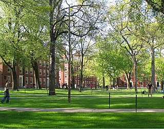
Harvard Yard, in Cambridge, Massachusetts, is the oldest part of the Harvard University campus, its historic center and modern crossroads. It contains most of the freshman dormitories, Harvard's most important libraries, Memorial Church, several classroom and departmental buildings, and the offices of senior University officials including the President of Harvard University.
The Williston Northampton School, or "Williston," is a private co-educational preparatory school for boarding and day students in seventh grade through post-graduate year located in Easthampton, Massachusetts.

The North Branch of the Millers River is a river in southwestern New Hampshire and northern Massachusetts in the United States. It is a tributary of the Millers River, which flows west to the Connecticut River, which in turn flows south to Long Island Sound, an arm of the Atlantic Ocean.
Henry C. Dudley (1813–1894), known also as Henry Dudley, was an English-born North American architect, known for his Gothic Revival churches. He was a founding member of the American Institute of Architects and designed a large number of churches, among them Saint Paul's Episcopal Cathedral in Syracuse, New York, built in 1884, and Trinity Church, completed in 1858.

The Amherst Central Business District is a historic district encompassing the heart of downtown Amherst, Massachusetts. Centered on the northern section of the long town common, the area has been the civic and commercial heart of the town since the 18th century. The district was listed on the National Register of Historic Places in 1991, and slightly enlarged in 2011.

The Lincoln–Sunset Historic District is a residential historic district located west of the downtown area of Amherst, Massachusetts. Colloquially known as Millionaire's Row, the district extends along Lincoln and Sunset Avenues between Northampton Street and the campus of the University of Massachusetts, Amherst. This area was one of Amherst's first planned residential subdivisions, and features a large number of high-quality houses, built by merchants, businessmen, and academics. It was added to the National Register of Historic Places in 1993.
The Prospect—Gaylord Historic District is a historic district encompassing a residential area built up mostly in the late 19th century just outside the central business district of Amherst, Massachusetts. Contributing properties include most of the houses on Prospect Street, which parallels Pleasant Street, as well as properties on Gaylord and Amity Streets running west from Prospect. These houses are generally in late Victorian styles such as Queen Anne, although some, for example a workman's house at 24 Gaylord Street, are in a more vernacular style. A central element of the district is the Hope Community Church, a historically African American church built in 1912 for a congregation whose history dates to 1869. Funds for its construction were raised in part through the efforts of W.E.B. Du Bois. The district was listed on the National Register of Historic Places in 1993.

The East Ridge Historical Area of UMass Amherst consists of several of the older lecture halls on campus, primarily those used by the entomology, plant pathology and other natural science programs. These buildings were originally located adjacent to the campus orchard where the Central Residential Area currently stands today. The district consists mainly of lecture halls that were built prior to the first World War by the Massachusetts Agricultural College; however, it is also home to the Boltwood-Stockbridge House, the oldest house in Amherst.

The Chestnut Ridge Historical Area contains a wide range of the oldest buildings on the UMass Amherst campus, including its iconic chapel, the campus war memorial, the W. E. B. Du Bois Library, and the last remaining barn from the founding years of the Massachusetts Agricultural College.

The campus of the University of Massachusetts Amherst is located nearly entirely in Amherst, Massachusetts, United States, with a portion located in Hadley. Founded on 310 acres in rural Western Massachusetts, the campus has grown to nearly 1,450 acres.
The Jones Library of Amherst, Massachusetts is a public library with three locations, the main building and two branches. The library was established in 1919 by a fund set up in the will of lumberman Samuel Minot Jones. The library is governed by a Board of Trustees and provides a range of library materials, electronic resources, programming, special collections and events for residents of Amherst and the surrounding area. The library is on the Association of Library Trustees, Advocates, Friends and Foundations’ Literary Landmark Register in recognition of its association with poet Robert Frost.


