India is the second most populated country in the world with nearly a fifth of the world's population. According to the 2017 revision of the World Population Prospects population stood at 1,324,171,354.

Languages spoken in India belong to several language families, the major ones being the Indo-Aryan languages spoken by 78.05% of Indians and the Dravidian languages spoken by 19.64% of Indians. Languages spoken by the remaining 2.31% of the population belong to the Austroasiatic, Sino-Tibetan, Tai-Kadai and a few other minor language families and isolates. India (780) has the world's second highest number of languages, after Papua New Guinea (839).

Nagaland is a state in northeastern India. It borders the state of Assam to the west, Arunachal Pradesh and Assam to the north, Myanmar to the east, and Manipur to the south. The state capital is Kohima, and the largest city is Dimapur. It has an area of 16,579 square kilometres (6,401 sq mi) with a population of 1,980,602 per the 2011 Census of India, making it one of the smallest states of India.
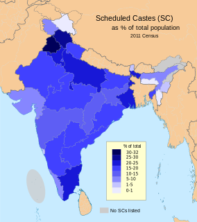
The Scheduled Castes (SCs) and Scheduled Tribes (STs) are officially designated groups of historically disadvantaged people in India. The terms are recognised in the Constitution of India and the groups are designated in one or other of the categories. For much of the period of British rule in the Indian subcontinent, they were known as the Depressed Classes.

Bathinda district is in Malwa region of Punjab, India. The districts encompasses an area of 3,385 square kilometres. According to area, Bathinda District is the third largest in Punjab. It is bounded by Faridkot district and Moga district on the north, Mukatsar district on the west, Barnala and Mansa districts on the east, and the state of Haryana on the south. Bathinda is cotton producing belt of Punjab.
The decennial Census of India has been conducted 15 times, as of 2011. While it has been undertaken every 10 years, beginning in 1872 under british Viceroy Lord Mayo, the first complete census was taken in 1881. Post 1949, it has been conducted by the Registrar General and Census Commissioner of India under the Ministry of Home Affairs, Government of India. All the censuses since 1951 were conducted under the 1948 Census of India Act. The last census was held in 2011. The next will be held in 2021. Also it was 1st conducted at the time of industrial revolutions too
A census town is a type of town that satisfies certain characteristics, depending on the country in which it is located.
The 15th Indian Census was conducted in two phases, house listing and population enumeration. House listing phase began on 1 April 2010 and involved collection of information about all buildings. Information for National Population Register (NPR) was also collected in the first phase, which will be used to issue a 12-digit unique identification number to all registered Indian residents by Unique Identification Authority of India (UIDAI). The second population enumeration phase was conducted between 9 and 28 February 2011. Census has been conducted in India since 1872 and 2011 marks the first time biometric information was collected. According to the provisional reports released on 31 March 2011, the Indian population increased to 1.21 billion with a decadal growth of 17.70%. Adult literacy rate increased to 74.04% with a decadal growth of 9.21%. The motto of the census was 'Our Census, Our future'.

Avarkhod is a village in Belgaum district in the southern state of Karnataka, India. famous for hanuman temple and grape is a backbone of avarkhod
Gulaganjikoppa is a village in Belgaum district in the southern state of Karnataka, India.
Hirekoppa K.S. is a village in Belgaum district in the southern state of Karnataka, India.
Ingalagi is a panchayat village in Belgaum district in the southern state of Karnataka, India.
Molmanatti is a village in Belgaum district of Karnataka, India.