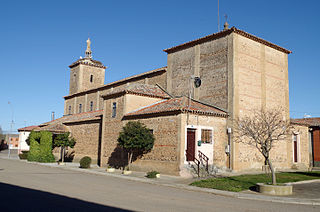
Andolucas | |
|---|---|
Municipality and village | |
| Country | |
| Province | La Rioja Province |
| Time zone | UTC−3 (ART) |
Andolucas is a municipality and village in La Rioja Province in northwestern Argentina. [1]
Andolucas | |
|---|---|
Municipality and village | |
| Country | |
| Province | La Rioja Province |
| Time zone | UTC−3 (ART) |
Andolucas is a municipality and village in La Rioja Province in northwestern Argentina. [1]

The Arctic Archipelago, also known as the Canadian Arctic Archipelago, is an archipelago lying to the north of the Canadian continental mainland, excluding Greenland and Iceland.
Martin Peninsula is a peninsula about 60 nautical miles long and 20 nautical miles wide that is ice-covered except for a few rock outcrops along its margins, located between Getz Ice Shelf and Dotson Ice Shelf on the coast of Marie Byrd Land, Antarctica. The farthest point of the peninsula is Jacobsen Head.

The Usarp Mountains are a major mountain range in North Victoria Land, Antarctica. They are west of the Rennick Glacier and trend north to south for about 190 kilometres (118 mi). The mountains are bounded to the north by Pryor Glacier and the Wilson Hills. They are west of the Bowers Mountains.
The Scott Mountains are a large number of isolated peaks lying south of Amundsen Bay in Enderby Land of East Antarctica, Antarctica. Discovered on 13 January 1930 by the British Australian New Zealand Antarctic Research Expedition (BANZARE) under Sir Douglas Mawson. He named the feature Scott Range after Captain Robert Falcon Scott, Royal Navy. The term mountains is considered more appropriate because of the isolation of its individual features.

Jason was a Norwegian whaling vessel laid down in 1881 by Rødsverven in Sandefjord, Norway, the same shipyard which later built Ernest Shackleton's ship Endurance. The ship, financed by Christen Christensen, an entrepreneur from Sandefjord, was noted for his participation in an 1892-1893 Antarctic expedition led by Carl Anton Larsen.
Ueda Glacier is a large glacier flowing eastward along the south side of the Scaife Mountains to enter Hansen Inlet near the base of Antarctic Peninsula. It was mapped by United States Geological Survey (USGS) from surveys and U.S. Navy air photos from 1961 to 1967 and named by Advisory Committee on Antarctic Names (US-ACAN) for Herbert T. Ueda who, with B. Lyle Hansen, was in charge of the deep core drilling program at Byrd Station, summers 1966-67 and 1967–68.

Villamandos is a municipality located in the province of León, Castile and León, Spain. According to the 2004 census (INE), the municipality had a population of 374 inhabitants.
Sillard Islands is a group of small ice-covered islands lying close to Cape Mascart, the northeast extremity of Adelaide Island. Discovered by the French Antarctic Expedition, 1908–10, under Charcot, and named for Director Sillard of the French Montevideo Co., Montevideo, Uruguay, whose company made repairs on Charcot's ship, the Pourquoi Pas ?.

Liv Glacier is a steep valley glacier, 40 nautical miles long, emerging from the Antarctic Plateau just southeast of Barnum Peak and draining north through the Queen Maud Mountains to enter Ross Ice Shelf between Mayer Crags and Duncan Mountains. It was discovered in 1911 by Roald Amundsen, who named it for the daughter of Fridtjof Nansen.

Ibirajuba is a city located in the state of Pernambuco, Brazil. Located at 182 km away from Recife, capital of the state of Pernambuco. Has an estimated population of 7,768 inhabitants.
Eucaliptus is a small town in Bolivia. In 2010 it had an estimated population of 2354.
Amuschinas is a municipality and village in La Rioja Province in northwestern Argentina.
Pozo de la Piedra is a town and municipality in Catamarca Province in northwestern Argentina.
The Cenobite Rocks are a small isolated group of rocks lying 5 nautical miles (9 km) northwest of Cape Adriasola, off the southwest coast of Adelaide Island. The group was so named by the UK Antarctic Place-Names Committee in 1963 because of its isolated position.
Ward Islands is a group of two small islands and off-lying rocks forming the southern part of the Amiot Islands, off the southwest part of Adelaide Island. Named by the United Kingdom Antarctic Place-Names Committee (UK-APC) for Herbert G.V. Ward, Chief Engineer of RRS John Biscoe, 1948–1962, which ship assisted the Royal Navy Hydrographic Survey Unit which charted this group in 1963.
Cumbers Reef is a group of rocks aligned in an arc forming the north and west parts of the Amiot Islands, off the southwest part of Adelaide Island. It was named by the UK Antarctic Place-Names Committee for Roger N. Cumbers, 3rd officer of RRS John Biscoe, 1961–62, the ship which assisted the Royal Navy Hydrographic Survey Unit in the charting of this area in 1963.

Demorest Glacier is a glacier on the northeast side of Hemimont Plateau which flows southeast into Whirlwind Inlet between Flint Glacier and Matthes Glacier, on the east coast of Graham Land. It was discovered by Sir Hubert Wilkins on a flight of December 20, 1928, and photographed from the air by the United States Antarctic Service in 1940. It was charted by the Falkland Islands Dependencies Survey in 1947 and named for Max H. Demorest, an American glaciologist.

Renaud Glacier is a heavily crevassed glacier on the east side of Hemimont Plateau flowing southeast to enter Seligman Inlet between Lewis Glacier and Choyce Point, on the east coast of Graham Land. The glacier was first photographed by the United States Antarctic Service (USAS), 1939–41. Named by United Kingdom Antarctic Place-Names Committee (UK-APC) for Andre Renaud, Swiss glaciologist and chairman of the Swiss Glacier Commission, 1955–74.