
Crystal Palace is an area in south London, England, named after the Crystal Palace Exhibition building, which stood in the area from 1854 until it was destroyed by fire in 1936. Approximately 7 miles (11 km) south-east of Charing Cross, it includes one of the highest points in London, at 367 feet (112 m), offering views over the capital. The area has no defined boundaries and straddles five London boroughs and three postal districts, although there is a Crystal Palace electoral ward and Crystal Palace Park in the London Borough of Bromley. It forms a part of the greater area known as Upper Norwood, and is contiguous with the areas of Anerley, Dulwich Wood, Gipsy Hill, Penge, South Norwood and Sydenham.

Penge is an area of South East London, England, in the London Borough of Bromley, 3.5 miles (5.6 km) west of Bromley, 3.7 miles (6.0 km) north east of Croydon and 7.1 miles (11.4 km) south east of Charing Cross.

Beckenham is a constituency represented in the House of Commons of the Parliament of the United Kingdom since 2010 by Bob Stewart, a Conservative.
South African may relate to:

The Croydon Canal ran 9+1⁄4 miles (15 km) from Croydon, via Forest Hill, to the Grand Surrey Canal at New Cross in south London, England. It opened in 1809 and closed in 1836, the first canal to be abandoned by an Act of Parliament.
The London and Croydon Railway (L&CR) was an early railway in England. It opened in 1839 and in February 1846 merged with other railways to form the London Brighton and South Coast Railway (LB&SCR).

South Norwood is a district of south-east London, England, within the London Borough of Croydon and the historic county of Surrey. It is located 7.8 miles (12.5 km) south-east of Charing Cross, north of Woodside and Addiscombe, east of Selhurst and Thornton Heath, south of Crystal Palace/Upper Norwood and Anerley, and west of Elmers End and Penge.

Port Shepstone is a large town situated on the mouth of the Mzimkhulu River, the largest river on the KwaZulu-Natal South Coast of South Africa. It is located halfway between Hibberdene and Margate and is positioned 120 km south of Durban. It is the administrative, educational and commercial centre for southern Natal.

Penge West railway station is located in Penge, a district of the London Borough of Bromley in south London. The station is operated by London Overground, with Overground and Southern trains serving the station. Thameslink and some Southern services pass through the station. It is 7 miles 15 chains down the line from London Bridge, in Travelcard Zone 4.
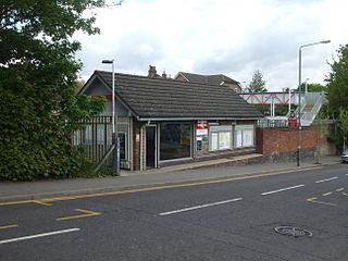
Anerley railway station is in the London Borough of Bromley in south London. The station is operated by London Overground, with Overground and Southern trains serving the station. It is 7 miles 47 chains down the line from London Bridge, in Travelcard Zone 4.

The R102 is a Regional Route in South Africa. It is the route designation for all old sections of the N2, thus it is a discontinuous road that resumes in areas where a new N2 has been constructed.
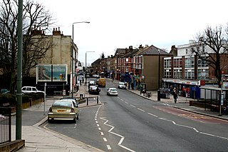
Anerley is an area of south east London, England, within the London Borough of Bromley. It is located 7 miles (11 km) south south-east of Charing Cross, to the south of Crystal Palace and Upper Norwood, west of Penge, north of Elmers End and South Norwood.
Penge Common was an area of north east Surrey and north west Kent which now forms part of London, England; covering most of Penge, all of Anerley, and parts of surrounding suburbs including South Norwood. It abutted the Great North Wood and John Rocque's 1745 map of London and its environs showed that Penge Common now included part of that wood.

London Buses route 157 is a Transport for London contracted bus route in London, England. Running between Crystal Palace and Morden station, it is operated by Arriva London.
Anerley is an unincorporated community in the western region of Saskatchewan located about 4 km north of Highway 44, about 20 km southwest of the Outlook and is about 125 km south west of Saskatoon.

Jacaranda is the fifth studio album by South African musician, songwriter, and producer Trevor Rabin, released on 8 May 2012 on Varèse Sarabande. His first solo album of new material since Can't Look Away (1989), Rabin started work on the album in 2007 by writing music in various styles that was challenging for him to play, including jazz fusion, rock, blues, classical, and bluegrass. Most of the album's song titles refer to Rabin's experiences while growing up in South Africa. Recording took place over a six-year period at his studio in Los Angeles. Five guest musicians perform on the album, including drummers Lou Molino III, Vinnie Colaiuta, Rabin's son Ryan, bassist Tal Wilkenfeld, and singer Liz Constantine.
Anerley is a coastal village in the South Coast of KwaZulu-Natal, South Africa.
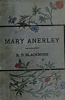
Mary Anerley: a Yorkshire tale is a three-volume novel by R. D. Blackmore published in 1880. It is set in the rugged landscape of Yorkshire's North Riding and the sea-coast of its East Riding.