Mozambique, officially the Republic of Mozambique, is a country located in southeast Africa bordered by the Indian Ocean to the east, Tanzania to the north, Malawi and Zambia to the northwest, Zimbabwe to the west, and Eswatini and South Africa to the southwest. The sovereign state is separated from the Comoros, Mayotte and Madagascar by the Mozambique Channel to the east. The capital and largest city is Maputo.
Chinde is a town of Mozambique, and a port for the Zambezi valley. It is located on the Chinde River, and is an important fishing center. It exports copra and sugar, and had a population of 16,500 in 1980. Chinde lies in Chinde District of Zambezia Province.

Nampula is a province of northern Mozambique. It has an area of 79,010 km2 (30,510 sq mi) and a population of 5,758,920, making it the most populous province in Mozambique. Nampula is the capital of the province.

Angoche is a district, city and municipality located in Nampula Province in north-eastern Mozambique. The district has limits in the North with Mogincual District, in the South with Larde District, to the east with the Indian Ocean and to the west with Mogovolas District. The principal town is Angoche. It is located 185 km from the provincial capital, Nampula City.

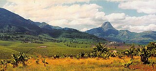
Gurúè is a town located in the northern part of Mozambique, near the center of the province of Zambezia. It serves as the principal town of Gurué District, and is Mozambique's largest tea estate. According to the 2007 census, the town had a population of 145,466, an increase from the 99,335 inhabitants counted in the 1997 census.

Quelimane is a seaport in Mozambique. It is the administrative capital of the Zambezia Province and the province's largest city, and stands 25 km (16 mi) from the mouth of the Rio dos Bons Sinais. The river was named when Vasco da Gama, on his way to India, reached it and saw "good signs" that he was on the right path. The town was the end point of David Livingstone's west-to-east crossing of south-central Africa in 1856. Portuguese is the official language of Mozambique, and many residents of the areas surrounding Quelimane speak Portuguese. The most common local language is Chuabo. Quelimane, along with much of Zambezia Province, is extremely prone to floods during Mozambique's rainy season.

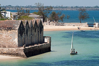
The Island of Mozambique lies off northern Mozambique, between the Mozambique Channel and Mossuril Bay, and is part of Nampula Province. Prior to 1898, it was the capital of colonial Portuguese East Africa. With its rich history and sandy beaches, the Island of Mozambique is a UNESCO World Heritage Site and one of Mozambique's fastest-growing tourist destinations. It has a permanent population of approximately 14,000 people and is served by nearby Lumbo Airport on the Nampula mainland. The name of the country, Mozambique, is derived from the name of this island.

Sofala, at present known as Nova Sofala, used to be the chief seaport of the Mwenemutapa Kingdom, whose capital was at Mount Fura. It is located on the Sofala Bank in Sofala Province of Mozambique. The first recorded use of this port town was by Mogadishan merchants. One possible etymology for Sofala is "go and cultivate" in the Somali language, showing the city as a hub for gold.

The Angoche Sultanate was an important sultanate centered on the islands of Angoche, present-day Northern Mozambique coastline. Established in the late 15th century by dissidents from the Kilwa Sultante, the sultanate arose during the decline of the Kilwa and Sofala, serving as an alternative entrepôt outside of Portuguese control to the inland trade fairs in the Zambezi and Mashonaland. The trade was mainly in ivory, ambergris, gold, and slaves, though the local craftsmen were known throughout the east for the straw mats and straw hats which they made.

Education in Mozambique is organized by three main stages: primary education, secondary education and higher education. Although having a national public education system, several educational programmes and initiatives in Mozambique are mainly funded and supported by the international community.

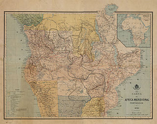
The Pink Map, also known as the Rose-Coloured Map, was a map prepared in 1885 to represent the Kingdom of Portugal's claim of sovereignty over a land corridor connecting the Portuguese colonies of Angola and Mozambique during the Scramble for Africa. The area claimed included most of modern-day Zimbabwe and large parts of modern-day Zambia and Malawi.

Mozambique is a Christian majority country, with Islam being a minority faith practiced by around 17.5% of the population as of 2020. The faith was introduced by merchants visiting the Swahili coast, as the region was part of the trade network that spanned the Indian Ocean. This later led to the formation of several officially Muslim political entities in the region.
Articles related to Mozambique include:

Angoche District is a district of Nampula Province in north-eastern Mozambique, with limits in the north with Mogincual District, in the south with Larde District, to the east with the Indian Ocean and to the west with Mogovolas District. The principal town is Angoche. It is located 185 km from the provincial capital, Nampula City.

Maganja da Costa District is a district of Zambezia Province in Mozambique.

Intense Tropical Cyclone Jokwe was the first tropical cyclone to make landfall in Mozambique since Cyclone Favio struck in the previous year, and was the most recent cyclone to make landfall on Mozambique until Cyclone Dineo in 2017. The tenth named storm of the 2007–08 South-West Indian Ocean cyclone season, Jokwe was first classified as a tropical depression on 2 March over the open Southwest Indian Ocean. It tracked west-southwest, crossing northern Madagascar as a tropical storm on 5 March before intensifying into a tropical cyclone on 6 March. Jokwe rapidly intensified to reach peak winds of 195 km/h (121 mph), before weakening slightly and striking Nampula Province in northeastern Mozambique. It quickly weakened while paralleling the coastline, though the storm restrengthened as it turned southward in the Mozambique Channel. Late in its duration, it remained nearly stationary for several days, and steadily weakened due to wind shear before dissipating on 16 March.
Mussa Bin Bique, other names Musa Al Big, Mossa Al Bique, Mussa Ben Mbiki or Mussa Ibn Malik, was ruler of the Island of Mozambique and wealthy merchant during the XVth century, before the Portuguese took over the island in 1544.

Stone Town is a town situated towards the northern end of the Island of Mozambique.
The Sangage Sheikhdom was a coastal African sheikhdom in modern-day Mozambique, established in the mid-1600s and lasting until 1913. The people of Sangage retained a distinct culture but are related to the Swahili people; their language, Esangaji, is also similar to the Swahili language.

The Portugal–Angoche conflict refers to a series of wars between the Angoche Sultanate and the Portuguese Empire between 1847 and 1910.


