Malham Cove is a large curved limestone formation 0.6 miles (1 km) north of the village of Malham, North Yorkshire, England. It was formed by a waterfall carrying meltwater from glaciers at the end of the last Ice Age more than 12,000 years ago. Today it is a well-known beauty spot and rock climbing crag within the Yorkshire Dales National Park. A large limestone pavement lies above the cove.

Cheddar Gorge is a limestone gorge in the Mendip Hills, near the village of Cheddar, Somerset, England. The gorge is the site of the Cheddar show caves, where Britain's oldest complete human skeleton, Cheddar Man, estimated to be 9,000 years old, was found in 1903. Older remains from the Upper Late Palaeolithic era have been found. The caves, produced by the activity of an underground river, contain stalactites and stalagmites. The gorge is part of a Site of Special Scientific Interest called Cheddar Complex.

Pelion or Pelium is a mountain at the southeastern part of Thessaly in northern Greece, forming a hook-like peninsula between the Pagasetic Gulf and the Aegean Sea. Its highest summit, Pourianos Stavros, is 1,624 metres (5,328 ft) amsl. The Greek National Road 38 (GR-38) runs through the southern portion of the peninsula and GR-38A runs through the middle.

The Gandaki River, also known as the Narayani and the Gandak, is one of the major rivers in Nepal and a left bank tributary of the Ganges in India. Its total catchment area amounts to 46,300 km2 (17,900 sq mi), most of it in Nepal. In the Nepal Himalayas, it is notable for its deep canyon. The basin also contains three mountains over 8,000 m (26,000 ft), namely Dhaulagiri, Manaslu and Annapurna I. Dhaulagiri is the highest point of the Gandaki basin.

Iron Cove is a bay on the Parramatta River, in the inner-west of Sydney, in the state of New South Wales, Australia. It is approximately 5 kilometres (3.1 mi) due west of Sydney's central business district. It is surrounded by the suburbs of Birchgrove, Balmain, Rozelle, Lilyfield, Haberfield, Five Dock, Rodd Point, Russell Lea and Drummoyne. The bay extends from Longnose Point to the south-west and is fed by the Hawthorne Canal and the Iron Cove Creek.

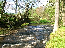
Crichope Linn or Crichop Linn, originally Creehope is a gorge and waterfall near Gatelawbridge in Dumfries and Galloway, southern Scotland. Linn is the Scots language word for waterfall. The etymology of the names 'Cree' or 'Crich' may derive from Gaelic for 'Boundary' and 'Hope' from the Scots for 'a valley among hills,' an apt description.

Carboniferous Limestone is a collective term for the succession of limestones occurring widely throughout Great Britain and Ireland that were deposited during the Dinantian Epoch of the Carboniferous Period. These rocks formed between 363 and 325 million years ago. Within England and Wales, the entire limestone succession, which includes subordinate mudstones and some thin sandstones, is known as the Carboniferous Limestone Supergroup.

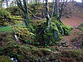
Cleeves Cove or Blair Cove is a solutional cave system on the Dusk Water in North Ayrshire, Scotland, close to the town of Dalry.
Mysterious tunnels or "secret passages" are a common element of the local folklore tradition in Europe. Such tunnels are said to physically link prominent places such as country houses, castles, churches, ancient monuments and other, often medieval, buildings.
The Tennessee River Blueway is a 50-mile (80 km) section of the Tennessee River that flows between the Chickamauga Dam and the Nickajack Dam and through downtown Chattanooga, Tennessee and the Tennessee River Gorge. The city of Chattanooga and the Tennessee River Gorge Trust along with other agencies have designated the section of river as a blueway for a canoe and kayak paddlers to travel and enjoy. Along the way, travelers will find primitive camping areas next to the river, a mix of museums, restaurants, activities, entertainment and natural attractions. From there, the Blueway meanders its way to quieter places like Williams Island State Archaeological Park. Williams Island divides the river channel with a 450-acre (1.8 km2) tract of land inhabited only by wildlife. From about 1000 to 1650, this area was home to several Native American tribes. It is now managed by the Tennessee River Gorge Trust and popular with birders and naturalists, as well as archaeologists. Then next of course is the 26-mile (42 km) stretch of the Tennessee River Gorge, a steep canyon formed by the Tennessee River. The scenic terrain of the Tennessee River Gorge creates a unique diversity of land forms. The land provides habitats for more than a thousand varieties of plants, ferns, trees, grasses and flowers as well as a wildlife population. Many of these are rare or endangered species such as the mountain skullcap. Dozens of archaeological sites bear evidence of man's presence in the Gorge for at least 10,000 years. There is a secluded spot where you can see Nickajack Cave from the water. Tennessee Valley Authority biologists monitor its bat population and encourage the public to "bat watch." There is no cave access, but canoeists and kayakers can drift at twilight with binoculars in hand to observe the comings and goings of these small but busy nocturnal creatures. There are many camping options and points of interest along the blueway.

The Bode Gorge is a 10 kilometres (6.2 mi) long ravine that forms part of the Bode valley between Treseburg and Thale in the Harz Mountains of central Germany. The German term, Bodetal, is also used in a wider sense to refer to the valleys of the Warme and Kalte Bode rivers that feed the River Bode.
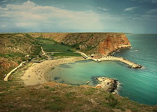
Bolata is a small cove and Nature reserve located in the Northern Bulgarian Black Sea Coast.
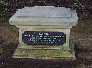
A cholera pit was a burial place used in a time of emergency when the disease was prevalent. Such mass graves were often unmarked and were placed in remote or specially selected locations. Public fears of contagion, lack of space within existing churchyards and restrictions placed on the movements of people from location to location also contributed to their establishment and use. Many of the victims were poor and lacked the funds for memorial stones, however memorials were sometimes added at a later date.
Yordas Cave is a solutional cave in Kingsdale, North Yorkshire, England. It has been renowned since the eighteenth century as a natural curiosity, and was a show cave during the nineteenth century. It is now a popular destination for cavers, walkers, and outdoor activity groups.

Dunton Cove or the Covenanters' Cave is an artificial cave in a craggy outcrop of rocks overlooking the Craufurdland Water just below the confluence of the Dunton Water and the Calf Fauld Water in East Ayrshire, Scotland, close to the village of Waterside. Traditionally it was used as a hiding place for Covenanters in the 17th century during the so-called 'Killing Times' of the 1680s.

Peden's Cave is at least partly artificial and is set into a craggy outcrop of red sandstone rocks overlooking the River Lugar just below the farm of Auchinbay in East Ayrshire, Scotland, close to the town of Ochiltree. Traditionally it is said that this cave was used as a hiding place for Covenanters, including the famous Covenanter minister Alexander Peden in the 17th century, mainly during the so-called 'Killing Times' of the 1680s.

Wallace's Cave in the Lugar Gorge at Auchinleck in the Parish of Auchinleck is an 18th-century grotto contemporary with Dr Johnson's Summerhouse, also located on the Auchinleck Estate. It shows superior workmanship in its construction, possibly being the enlargement of a pre-existing cave. The cave or grotto lies downstream of the confluence of the Dippol Burn with the River Lugar and is reached via a once well formed path, however access is now hazardous due to the condition of the cliff edge path and the vertical drop into the River Lugar.

The early-fifteenth century Chapel of Our Lady of the Crag is located in an old quarry on Abbey Road beside the Nidd Gorge at Knaresborough and is an early 15th century chapel cut out of the sandstone of the river gorge cliff face. It is a Marian shrine on the old pilgrim's route to the now demolished Knaresborough Priory and close to the ancient stone quarry that was used for building works at Knaresborough Castle, the parish church and elsewhere. It was also once known as Quarry Chapel or Our Lady of the Quarry.
The early 13th century St Robert's Cave and Chapel of the Holy Cross also known with variants such as St Robert's Chapel and Chapel of the Holy Rood are located on Abbey Road beside the River Nidd in its gorge at Knaresborough. The cave is a rare example of a medieval hermitage, cut out of the magnesian limestone river gorge with a domestic area externally and the chapel of the Holy Cross which originally housed the saint's grave.

Bruce's Cave or the Dunskellie Grotto is a relatively small and mainly artificial cave created in the red sandstone cliffs about 9 metres above the Kirtle Water at Cove, Kirkpatrick-Fleming, Dumfries and Galloway, Scotland. It has been associated with Robert the Bruce and the famous incident with the spider struggling to build its web.