
Samuel de Champlain was a French explorer, navigator, cartographer, draftsman, soldier, geographer, ethnologist, diplomat, and chronicler. He made between 21 and 29 trips across the Atlantic Ocean, and founded Quebec City, and New France, on 3 July 1608. An important figure in Canadian history, Champlain created the first accurate coastal map during his explorations and founded various colonial settlements.
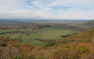
The Ottawa Valley is the valley of the Ottawa River, along the boundary between Eastern Ontario and the Outaouais, Quebec, Canada. The valley is the transition between the Saint Lawrence Lowlands and the Canadian Shield. Because of the surrounding shield, the valley is narrow at its western end and then becomes increasingly wide as it progresses eastward. The underlying geophysical structure is the Ottawa-Bonnechere Graben. Approximately 1.3 million people reside in the valley, around 80% of whom reside in Ottawa. The total area of the Ottawa Valley is 2.4 million ha. The National Capital Region area has just over 1.4 million inhabitants in both provinces.
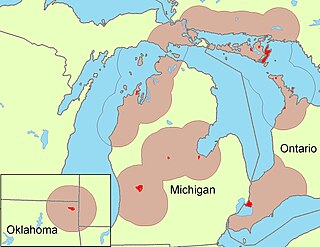
The Odawa are an Indigenous American people who primarily inhabit land in the Eastern Woodlands region, now in jurisdictions of the northeastern United States and southeastern Canada. Their territory long preceded the creation of the current border between the two countries in the 18th and 19th centuries.

The Mattawa River is a river in central Ontario, Canada. It flows east from Trout Lake east of North Bay and enters the Ottawa River at the town of Mattawa. Counting from the head of Trout Lake, it is 76 kilometres (47 mi) long. The river's name comes from the Algonquin word for "meeting of waterways".

The Tomb of the Unknown Soldier is a tomb situated before the National War Memorial in Confederation Square, Ottawa, Ontario. The tomb is dedicated to Canadian service members, and holds the remains of an unidentified Canadian soldier who died in France during the First World War; selected from a Commonwealth War Grave near Vimy, in the vicinity where the Battle of Vimy Ridge took place.
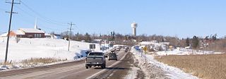
Whitewater Region is a township on the Ottawa River in Renfrew County, located within the scenic Ottawa Valley in eastern Ontario, Canada. Whitewater Region is made up of the former municipalities of Beachburg, Cobden, Ross and Westmeath, which were amalgamated into the current township on January 1, 2001.

Green Island in Ottawa, Ontario, Canada, is an island at the junction of the Rideau River, just off Sussex Drive in Ottawa at the Rideau Falls at the confluence with the Ottawa River. It is situated near the neighbourhood of New Edinburgh.

Mattawa is a town in northeastern Ontario, Canada at the confluence of the Mattawa and Ottawa Rivers in Nipissing District. The first Europeans to pass through this area were Étienne Brûlé and Samuel de Champlain.

The Rideau Falls are two 11-metre waterfalls located in Ottawa, Ontario, Canada, where the Rideau River empties into the Ottawa River. The falls are divided by Green Island, with Ottawa's Old City Hall just to the south. To the west of the falls is the headquarters of the National Research Council while to the east are the Canada and the World Pavilion and the French Embassy. Samuel de Champlain described the falls as "...a marvelous fall...it descends a height of twenty or twenty-five fathoms with such impetuosity that it makes an arch nearly four hundred paces broad." The falls were named by the early French for their resemblance to a curtain, or rideau in French. The Rideau River was later named after the falls. The Rideau Canal was constructed to bypass these falls and the Hog's Back Falls.

The Chaudière Falls, also known as the Kana:tso or Akikodjiwan Falls, are a set of cascades and waterfall in the centre of the Ottawa-Gatineau metropolitan area in Canada where the Ottawa River narrows between a rocky escarpment on both sides of the river. The location is just west of the Chaudière Bridge and Booth-Eddy streets corridor, northwest of the Canadian War Museum at LeBreton Flats and adjacent to the historic industrial E. B. Eddy complex. The islands surrounding the Chaudière Falls, counter-clockwise, are Chaudière Island, Albert Island, little Coffin Island was just south of Albert Island but is now submerged, Victoria Island and Amelia Island,, Philemon Island was originally called the Peninsular Village by the Wrights but became an island when the timber slide was built in 1829 it is now fused to south shore of City of Gatineau, and Russell Island, now submerged, was at the head of the Falls before the Ring dam was built. The falls are about 60 metres (200 ft) wide and drop 15 metres (49 ft). The area around the falls was once heavily industrialized, especially in the 19th century, driving growth of the surrounding cities.

The Bytown Museum is a museum in Ottawa located in the Colonel By Valley at the Ottawa Locks of the Rideau Canal at the Ottawa River, just below Parliament Hill. Housed in the Commissariat Building, Ottawa's oldest remaining stone building, the museum provides a comprehensive overview of the origins of Bytown and its development and growth into the present city of Ottawa.
Donald Harcourt De Lue was an American sculptor, best known for his public monuments.

Commissioners Park is a park in Ottawa, Ontario, Canada. It lies within the westernmost section of The Glebe, bounded by Dow's Lake, Preston Street, Carling Avenue and Dow's Lake Road.
Vernon March (1891–1930) was an English sculptor, renowned for major monuments such as the National War Memorial of Canada in Ottawa, Ontario, the Samuel de Champlain Monument in Orillia, Ontario, and the Cape Town Cenotaph, South Africa. Without the benefit of a formal education in the arts, he was the youngest exhibitor at The Exhibition of the Royal Academy of Arts.
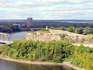
Kìwekì Point, formerly Nepean Point is a hill overlooking the Ottawa River in Ottawa, Ontario, Canada. It is located between the National Gallery of Canada and Alexandra Bridge. The site is managed by the National Capital Commission (NCC).

The Capital Pathway, also known informally as the Bike Path, is a 220-kilometre (140 mi) recreational pathway interlinking many parks, waterways and sites in Ottawa, Ontario and Gatineau, Quebec. Most of the pathway is paved, and allows an almost continuous route through the National Capital Region.

The Ideal Scout, also known as The Boy Scout, is the most famous work by Canadian sculptor R. Tait McKenzie (1867–1938). The original statue stood in front of the Cradle of Liberty Council at 22nd and Winter Streets in Philadelphia, Pennsylvania, from 1937 to 2013. Replicas can be found at Boy Scouts of America councils across the United States, as well as at Gilwell Park in London, England, and at Scouts Canada's national office in Ottawa. The Smithsonian American Art Museum's database lists 18 copies.
Hamilton Thomas Carlton Plantagenet MacCarthy was one of the earliest masters of monumental bronze sculpture in Canada. He is known for his historical sculptures, in particular his Pierre Dugua, Sieur de Mons at Annapolis Royal, Nova Scotia (1904) as well as Samuel de Champlain overlooking Parliament Hill on Nepean Point, Ottawa (1915), next to the National Gallery of Canada. His monument to the Ottawa volunteers who died in the South African War (1902) was moved to Confederation Park in 1969 after several moves. Other works include that of Ottawa mayor, Samuel Bingham, in Notre-Dame Cemetery in Vanier.
Roland Poulin is a Canadian contemporary sculptor whose work is characterized by its horizontality and weightiness. He has lived in Sainte-Angèle-de-Monnoir, Quebec, since 1986.


