Bodø is a municipality in Nordland county, Norway. It is part of the traditional region of Salten. The administrative centre of the municipality is the town of Bodø. Some of the notable villages in Bodø include Misvær, Skjerstad, Saltstraumen, Løding, Løpsmarka, Kjerringøy, Sørvær, and Fenes.

Fauske (Norwegian) or Fuossko (Lule Sami) is a municipality located in Nordland county, Norway. It is part of the traditional district of Salten. The administrative centre of the municipality is the town of Fauske. Some of the villages in Fauske include Nystad, Venset, Straumsnes, and Sulitjelma.

Hamarøy (Norwegian) or Hábmer (Lule Sami) is a municipality in Nordland county, Norway. It is part of the traditional district of Salten. The administrative centre of the municipality is the village of Oppeid. Other villages include Innhavet, Karlsøy, Presteid, Skutvika, Tømmerneset, Tranøy, and Ulvsvåg.

Evenes is a municipality in Nordland county, Norway. It is part of the traditional district of Ofoten. The administrative centre of the municipality is the village of Bogen. Other villages in Evenes include Liland, Tårstad, Dragvik, and the village of Evenes.

Ballangen is a municipality in Nordland county, Norway. It is part of the traditional district of Ofoten. The administrative centre of the municipality is the village of Ballangen. Other villages in the municipality include Bjørkåsen, Kjeldebotn, Kobbvika, and Skarstad.

Ofoten is a traditional district in Nordland county in Northern Norway. It consists of the municipalities of Tysfjord, Ballangen, Evenes, Tjeldsund, Narvik, and Lødingen. It is named after the main fjord, Ofotfjorden, which is at the center of this district. The 7,829-square-kilometre (3,023 sq mi) district was home to 29,968 residents in 2016, with almost half of the residents living in the town of Narvik.
The Beisfjord Bridge is a girder bridge in Narvik Municipality in Nordland county, Norway. The concrete bridge crosses the Beisfjorden on the west side of the town of Narvik. The 375-metre-long (1,230 ft) bridge connects Ankenes, a residential area on the west side of Narvik, southwest of the fjord, to the city centre of Narvik and the majority of the population is on the northeastern side. The bridge carries the European route E06 highway and it was completed in 1957.

Bjerkvik is a village in Narvik Municipality in Nordland county, Norway. The village is located at the end of Herjangsfjorden, an arm of Ofotfjorden. Bjerkvik sits less than 20 kilometres (12 mi) south of the border of Troms county and about 13 kilometres (8.1 mi) across the fjord from the town of Narvik. The 1.34-square-kilometre (330-acre) village has a population (2018) of 1,159 which gives the village a population density of 865 inhabitants per square kilometre (2,240/sq mi).

Håkvik or Håkvika (Norwegian) or Ginnasluokta (Northern Sami) is a village in Narvik Municipality in Nordland county, Norway. The village is located along the southern shore of the Ofotfjorden, southwest of the town of Narvik and the village of Ankenesstranda. Håkvik Chapel was built here in 1980. The European route E06 highway runs through the village.
Straumsnes or Strømsnes is a village in Narvik Municipality in Nordland county, Norway. The village is located along the Rombaken fjord between the town of Narvik and the village of Hergot. The village has a train station on the Ofotbanen railway line, between Narvik Station and Rombak Station. The village sits along the European route E06 highway, just southeast of the Rombak Bridge.

Drag (Norwegian) or Ájluokta (Lule Sami) or Áiluokta (Northern Sami) is a village in the municipality of Tysfjord in Nordland county, Norway. It is located along the Tysfjorden, about 180 kilometres (110 mi) northeast of the town of Bodø and about 110 kilometres (68 mi) south of the town of Narvik. The 0.44-square-kilometre (110-acre) village has a population (2018) of 319 which gives the village a population density of 725 inhabitants per square kilometre (1,880/sq mi).
Beis Fjord (English) is a fjord in Narvik Municipality in Nordland county, Norway. It is a fjord arm that branches off of the main Ofotfjorden, on the south side of the town of Narvik. The Beisfjord Bridge on the European route E06 highway crosses the fjord between Ankenesstranda and Narvik. The village of Beisfjord is located at the end of the 11.5-kilometre (7.1 mi) long fjord. The maximum depth of the fjord reaches 44 metres (144 ft) below sea level.
Bjørnfjell Chapel is a chapel of the Church of Norway in Narvik Municipality in Nordland county, Norway. It is located in the village of Bjørnfjell, just west of the border with Sweden. It is an annex chapel in the Bjerkvik parish which is part of the Ofoten prosti (deanery) in the Diocese of Sør-Hålogaland. The white, wooden chapel was built in a long church style in 1952 by the architect Bjarne Romsloe. The chapel is located in a rural area that is populated with vacation cabins that are popular with the residents of the town of Narvik.

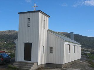
Håkvik Chapel is a parish church of the Church of Norway in Narvik Municipality in Nordland county, Norway. It is located in the village of Håkvik. It is an annex church for the Ankenes parish which is part of the Ofoten prosti (deanery) in the Diocese of Sør-Hålogaland. The brown, wooden church was built in a long church style in 1980 by the architect Einar Karstad. The church seats about 180 people.

Narvik is a town and the administrative centre of Narvik Municipality in Nordland county, Norway. The town is located along the Ofotfjorden in the Ofoten region. The town lies on a peninsula located between the Rombaken fjord and the Beisfjorden. The European route E06 highway runs through the Beisfjord Bridge and Hålogaland Bridge crossing the two small fjords surrounding the town.

Fagernes is a suburb of Narvik in Nordland county, Norway. Fagernes lies on the north side of Beis Fjord just southeast of Narvik and north of Ankenesstranda (Ankenes). Today Fagernes is best known as the terminus of the Ofoten Line. The Ofoten Line has its terminus at the Fagernes terminal, a large industrial area of Fagernes.

Ofoten is a former municipality in Nordland county, Norway. The 2,998.3-square-kilometre (1,157.7 sq mi) municipality existed from 1838 until its dissolution in 1884. The municipality included the areas on both sides of the inner part of the Ofotfjorden mostly in what is now the municipalities of Narvik, Ballangen, and Evenes. The administrative centre of Ofoten was the village of Narvik. After the municipality was dissolved in 1884, the name Ofoten has been used to refer to the region that once was this municipality.