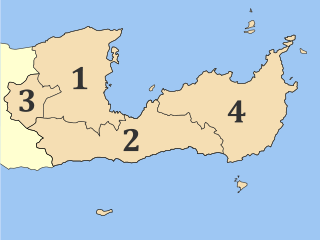
Lasithi is the easternmost regional unit on the island of Crete, to the east of Heraklion. Its capital is Agios Nikolaos, the other major towns being Ierapetra and Sitia. The mountains include the Dikti in the west and the Thrypti in the east. The Sea of Crete lies to the north and the Libyan Sea to the south.

Myrtos is a coastal village and a community in the west of the municipality of Ierapetra, in the Regional Unit of Lasithi on the Greek island of Crete. It is located 50 km (31 mi) from Agios Nikolaos and 15 km (9.3 mi) from Ierapetra, on the road to Viannos. A little to the west of the village is the iconic conical Kolektos mountain. Myrtos is situated on the Libyan Sea. The patron saint of the village is Saint Anthony. The population of the community is 518 (2021).

Ierapetra is a Greek city and municipality located on the southeast coast of Crete.

Koutsouras (Κουτσουράς) is a village in Lasithi regional unit, in Crete, Greece 22 kilometers east of Ierapetra. Its population is 818. It was the headquarters of the municipality of Makry Gialos and is the biggest village in the region. Key economic activities include agriculture and tourism. It has nice beaches and a golf course is due to be built over the next five years. The coast is rocky and there are beautiful pebble beaches with crystal clear waters. Today it is the seat of Makry Gialos municipal unit and part of Ierapetra municipality.

Episkopi is a village on the Greek island of Crete. Episkopi belongs to the community of Kato Chorio within the municipality of Ierapetra, Lasithi. It lies north of Ierapetra in the middle of the narrowest part of the island. The village has approximately one thousand inhabitants.

Thrypti is a mountain range in Lasithi in eastern Crete, Greece. It trends to the northeast from Ierapetra in the southwest in the direction of Sitia. However, it only goes half-way in that direction. The rest of the distance is completed by the distinct Ornon mountains, separated from the Thrypti by the Bebonas river valley, and the lower Western Siteia Foothills covering the space between the Ornon range and Sitia itself. The highest peak of Thrypti is Afentis, which is 1,476 m amsl. The three ranges constitute the West Sitia Mountains.

Makry Gialos is a former municipality in Lasithi, Crete, Greece, with a population 2,589 in 2021. It is located on the south-east coast of Crete. Since the 2011 local government reform it is part of the municipality Ierapetra, of which it is a municipal unit. The municipal unit has an area of 75.376 km2 (29.103 sq mi). The seat of the municipality was in Koutsouras, 22 kilometers east of Ierapetra. It was established in 1997 when the communities of Stavrochori, Chrysopigi, Lithines, Schinokapsala, Agios Stefanos, Oreino, Perivolakia and Pefkoi amalgamated into one municipality (Δήμος). In November 2011 the four communities Chrysopigi, Lithines, Perivolakia and Pefkoi passed to the municipality Siteia.
Schinokapsala is a community and a small village in Lasithi on Crete. It is situated 21 kilometers north-east from Ierapetra and 6 km from the sea. Since 2011 it belongs to the Ierapetra municipality.

Oreino is a small village in Lasithi regional unit on Crete, Greece. It is situated 28 kilometers northeast of Ierapetra and lies 10 kilometers from the Cretan south coast. Since 2011, it is part of the Ierapetra municipality. It is situated at 650 meters above sea level, east of the Thrypti mountains, in an area rich in vegetation. A gorge with the same name is also part of the village and contained a neo-Byzantine church with frescos.

Males is a historic village in the municipality of Ierapetra in Lasithi prefecture on Crete. It is situated 25 kilometers north-west of Ierapetra, 40 from Agios Nikolaos and 12 kilometers away from the sea. Together with nearby hamlets Hristos and Metaxohori Males until recently formed the Nea Mala municipality. It is built 550 meters above sea level, south east of Dikti mountain, in an area rich in vegetation. It is built where the ancient city of Mala was.
Ferma is a settlement in the municipality of Ierapetra on the island of Crete. It is situated at the coast, 11 kilometers east of Ierapetra.
Koutsounari is a settlement of 437 inhabitants on the island of Crete, along the slope of the Sitia Mountains. It is located 8 kilometers east of Ierapetra and 43 kilometers southeast of Agios Nikolaos. The village was established in the 1970s. Today it is best known for the nearby holiday destination of Long Beach.

Agios Ioannis is a village of Lasithi prefecture, in the municipality of Ierapetra, Crete, Greece. It lies 17 kilometers north-east of Ierapetra, 7 kilometers west of Schinokapsala, and 9 kilometers from the sea. It is south of Thripti mountain. The majority of the people that lived here have moved during the last three decades to the beach settlements of Koutsounari and Ferma, or to Ierapetra. The water from the springs follows a route across "Milonas gorge" and ends in the sea some 7 kilometers further. In the Aghios Ioannis area there are also a number of beaches, including the Long beach and Aghia Fotia.

Gdochia is a village on Crete 20 kilometers west of Ierapetra built in an area with views of Ierapetra town and the sea. It is said to receive his name from an ancient word that means "it has rain". In September 1943, over 40 residents of Gdochia were brutally executed by the Nazis.
Karydi may refer to several villages on Crete, Greece:
Kato Symi is a small historic village of Crete, in Heraklion regional unit, 31 km (19 mi) from Ierapetra and 74 km (46 mi) from Heraklion city. Today it belongs to Viannos municipality and borders the Ierapetra municipality. It lies about 780 m (2,560 ft) above sea level, south of Mount Dikti in a verdant mountainous area, which is probably the most wooded of Crete. Near the village, at an altitude of 1,200 m (3,900 ft), lies the ancient sanctuary of Hermes and Aphrodite. It is dated from the middle Minoan period and had been used for worship for more than 1,000 years. Kato Simi has been destroyed three times, by Arabs, Turks and finally by the German army in World War II, when it was the center of resistance of the Viannos–Ierapetra area against the Nazi occupying forces.

The Viannos massacres were a mass extermination campaign launched by German forces against the civilian residents of around 20 villages located in the areas of east Viannos and west Ierapetra provinces on the Greek island of Crete during World War II. The killings, with a death toll in excess of 500, were carried out on 14–16 September 1943 by Wehrmacht units. They were accompanied by the burning of most villages, looting, and the destruction of harvests.
Stavrochori is an historic village of eastern Crete. It belonged to the former province of Sitia and later to the former Makry Gialos municipality. Today it is part of Ierapetra municipality. It is located in a wooded valley, 29 kilometers north east from Ierapetra and 35 kilometers southwest from Sitia. Once it was the most populous village of the region and the administrative center of the surrounding settlements. Since the last 30 years, the majority of its population has moved to the seaside settlement of Koutsouras, 7 kilometers to the south. Stavrochori is a traditional village with many sights. It is also the birthplace of Ioannis Papachatzakis or "Stravogiannios", a violinist, who lived and died in Ierapetra. He was one of the most important Cretan traditional organ players of the last century.
Agios Stefanos is a village within the Lasithi prefecture in eastern Crete. It belonged to the former province of Siteia until that was abolished in 2006. Between 1997 and 2010, it was part of the former Makry Gialos municipality. Today, it is part of Ierapetra municipality. It is located 30 kilometers north-east of Ierapetra, 40 kilometers southwest of Sitia, and six kilometers east of Stavrohori. It can be approached through the famous forest of Pefkoseli. Its patron is Saint Stephen. Saint Stephen church, at the entrance of the village, is an ecclesiastical and historical monument of Crete. Since the last decade, the majority of the population has been moved to the village's seaside settlement of Makry Gialos, some six kilometers to the south. Makry Gialos is one of Crete's most important tourist resorts.

The Isthmus of Ierapetra is a strip of land on the Greek island of Crete which connects the easternmost municipality, Siteia, to the rest of the island. Its name comes from the largest settlement, Ierapetra (Ιεράπετρα), which is situated on the south coast.
