Pike, Pikes or The Pike may refer to:
Black Mountain may refer to:
High Point is a mountain peak within High Point State Park on the border of Wantage Township and Montague Township, Sussex County, New Jersey, United States. Located in the portion of the state known as the Skylands, it is the highest elevation in the state, with a peak elevation of 1,803 feet. The closest city is Port Jervis, New York, which lies to the northwest. Besides being the highest peak in New Jersey, High Point is also the highest peak of the Kittatinny Mountains. Three states – New Jersey, New York, and Pennsylvania – can be seen from the summit.

Khandala is a hill station in the Western Ghats in the state of Maharashtra, India, about 3 kilometres (1.9 mi) from Lonavala, 12 kilometres from Khopoli and 33.4 kilometres (20.8 mi) from Karjat.

The Taconic Mountains or Taconic Range are a range of the Appalachian Mountains, running along the eastern border of New York State and adjacent New England from northwest Connecticut to western Massachusetts, north to central western Vermont. A physiographic region of the larger New England province, the range includes notable summits, including its high point, 3,840 feet (1,170 m) Mount Equinox in Vermont, and 3,489 feet (1,063 m) Mount Greylock, the highest point in Massachusetts.

Hudson Highlands State Park is a non-contiguous state park in the U.S. state of New York, located on the east side of the Hudson River. The park runs from Peekskill in Westchester County, through Putnam County, to Beacon in Dutchess County, in the eastern section of the Hudson Highlands.

Breakneck Ridge is a mountain along the Hudson River between Beacon and Cold Spring, New York, straddling the boundary between Dutchess and Putnam counties. Its distinctive rocky cliffs are visible for a long distance when approached from the south, and together with Storm King Mountain on the opposite bank of the river forms Wey-Gat, or Wind Gate, the picturesque northern gateway to the Hudson Highlands.

The Hudson Highlands are mountains on both sides of the Hudson River in New York state lying primarily in Putnam County on its east bank and Orange County on its west. They continue somewhat to the south in Westchester County and Rockland County, respectively.

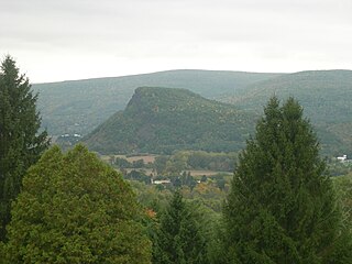
Anthony's Nose is a 900+ ft (270 m) peak in the Hudson Highlands along the east bank of the Hudson River in the hamlet of Cortlandt Manor, New York. It lies at the extreme northwest end of Westchester County, and serves as the east anchor of the Bear Mountain Bridge.
Round Mountain may refer to:

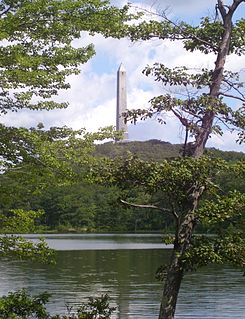
Beacon Mountain, locally Mount Beacon, is the highest peak of Hudson Highlands, located south of City of Beacon, New York, in the Town of Fishkill. Its two summits rise above the Hudson River behind the city and can easily be seen from Newburgh across the river and many other places in the region. The more accessible northern peak, at 1,516 feet (462 m) above sea level, has a complex of radio antennas on its summit; the 1,595 feet (486 m) southern summit has a fire lookout tower, which was built in 1931.
The nose is a protuberance in vertebrates which admits and expels air for respiration and contains olfactory receptors for sensing odors.
The Appalachian National Scenic Trail spans fourteen U.S. states during its roughly 2,200 miles (3,500 km)-long journey: Georgia, North Carolina, Tennessee, Virginia, West Virginia, Maryland, Pennsylvania, New Jersey, New York, Connecticut, Massachusetts, Vermont, New Hampshire, and Maine. The southern end is at Springer Mountain, Georgia, and it follows the ridgeline of the Appalachian Mountains, crossing many of its highest peaks and running almost continuously through wilderness before reaching the northern end at Mount Katahdin, Maine.
High Peak or High Peaks may refer to:

North Franklin Mountain is a mountain in the Franklin Mountains of El Paso, Texas, located in the Southwestern United States. North Franklin, at 7,192 feet (2,192 m), is the highest point in El Paso, and the 27th-highest mountain in the state of Texas. Surrounded by a state park and with a maintained trail leading to its summit, the mountain is a popular hiking destination.

Tegg's Nose is a hill east of Macclesfield in Cheshire, England. It has a short ridge with a high point of 380 metres (1246 feet) at SJ947725, terminating in a promontory at the southern end. It lies on the western edge of the Peak District, although outside the boundary of the national park. Much of the hill's area falls within the Tegg's Nose Country Park, managed by Cheshire East Council Countryside Management Service; Tegg's Nose is also part of the Environmentally Sensitive Area Scheme.
Vroman's Nose is a prominent geological feature in the town of Fulton, in Schoharie County, New York, United States. It is among the more popular hiking sites in upstate New York and is of significant historical note.

Bear Mountain Bridge Road is a three-mile (4.8 km), two-lane section of US 6/US 202 from the west approach to Bear Mountain Bridge to a former toll house in the Town of Cortlandt, New York, United States. Local residents sometimes refer to the road as the Goat Trail. It winds around the steep, rocky slopes of Anthony's Nose, the southernmost peak of the Hudson Highlands on the east side of the Hudson River. In its first mile from the junction with NY 9D it climbs 200 feet (61 m) to a scenic overlook that looks out over Iona Island, Dunderberg Mountain, the city of Peekskill and the Charles Point power plant. There are interpretive displays on the history of the area during the Revolutionary War, where the Hudson River Chain was deployed and the Battle of Forts Clinton and Montgomery was fought.