Anthonys Nose is a point, or escarpment located on the southern shore of Port Phillip Bay, between Dromana and McCrae, in Victoria, Australia.
Contents

Anthonys Nose is a point, or escarpment located on the southern shore of Port Phillip Bay, between Dromana and McCrae, in Victoria, Australia.
It was named by Charles La Trobe, who became the Superintendent of the Port Phillip District of New South Wales in 1839. He thought that the landform had a strong resemblance to Anthony's Nose (Westchester) on the Hudson River, New York. [1] [2]
In the early years of the European settlement of Dromana there were geographical obstacles to travelling by land. A journey from Melbourne to the area meant crossing swamps and streams. Anthony's Nose was the point where Arthur's Seat ended as the mountain "fell steeply to the sea". At high tide a traveller by foot, horse, or wagon found it necessary to wade, ride or drive through the water in order to round the point, as the only road stuck to the coastline. In addition it was difficult at high tide to negotiate the rocks which were then submerged underwater. An 1863 survey map shows that the road left the coastline at Foote St. and passed over the brow of the "Nose". Georgiana McCrae gave an account in her journal of Meyrick, in 1845, solving the problem by sleeping next to his bullock wagon as he waited for the tide to go out. Her diary also recorded various fishing expeditions at Anthony's Nose made by her husband, his employees, her sons, and the Boon wurrung Aboriginal locals who were the first custodians of that area. [3]
Over the years, the original escarpment was cut back to a cliff face. In the early 1920s, Anthony's Nose was further cut back by Mr Alnutt, an engineer who was contracted to finish the job in order to build Point Nepean Road, today known in parts as Nepean Highway.
Colin McLear, a descendant of one of the pioneering families on the Mornington Peninsula speculated that the water washed stones that are visible today in the man made cutting were either formed from water action in a riverbed (as on the Hudson River) or on a wave washed shore. He commented that before 1940 when a seawall was built around the "nose", "the shoreline there was thickly littered with water-washed stones." He was intrigued with both these theories as Port Phillip Bay was at one time a vast plain cut by the Yarra River where it may have joined the ocean near the present day Rye. The rocks underlying Arthur's Seat are Dromana granite, and the granite is bounded to the west by the Selwyn Fault.

The Wash is a rectangular bay and multiple estuary at the north-west corner of East Anglia on the East coast of England, where Norfolk meets Lincolnshire and both border the North Sea. One of Britain's broadest estuaries, it is fed by the rivers Witham, Welland, Nene and Great Ouse. It is a 620 km² biological Site of Special Scientific Interest. It is also a Nature Conservation Review site, Grade I, a National Nature Reserve, a Ramsar site, a Special Area of Conservation and a Special Protection Area. It is in the Norfolk Coast Area of Outstanding Natural Beauty and part of it is the Snettisham Royal Society for the Protection of Birds nature reserve.

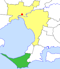
Port Phillip or Port Phillip Bay is a horsehead-shaped enclosed bay on the central coast of southern Victoria, Australia. The bay opens into the Bass Strait via a short, narrow channel known as The Rip, and is completely surrounded by localities of Victoria's two largest cities — metropolitan Greater Melbourne in the bay's main eastern portion north of the Mornington Peninsula, and the city of Greater Geelong in the much smaller western portion north of the Bellarine Peninsula. Geographically, the bay covers 1,930 km2 (750 sq mi) and the shore stretches roughly 264 km (164 mi), with the volume of water around 25 km3 (6.0 cu mi). Most of the bay is navigable, although it is extremely shallow for its size — the deepest portion is only 24 m (79 ft) and half the bay is shallower than 8 m (26 ft). Its waters and coast are home to seals, whales, dolphins, corals and many kinds of seabirds and migratory waders.

The Mornington Peninsula is a peninsula located south of Melbourne, Victoria, Australia. It is surrounded by Port Phillip to the west, Western Port to the east and Bass Strait to the south, and is connected to the mainland in the north. Geographically, the peninsula begins its protrusion from the mainland in the area between Pearcedale and an area north of Frankston. The area was originally home to the Mayone-bulluk and Boonwurrung-Balluk clans and formed part of the Boonwurrung nation's territory prior to European settlement.

Arthurs Seat is a mountainous and small locality on the Mornington Peninsula in Melbourne, Victoria, Australia, about 85 km south east of Melbourne's Central Business District, located within the Shire of Mornington Peninsula local government area. Arthurs Seat recorded a population of 414 at the 2021 census.

Dromana is a seaside suburb on the Mornington Peninsula in Melbourne, Victoria, Australia, 57 km (35 mi) south of Melbourne's Central Business District, located within the Shire of Mornington Peninsula local government area. Dromana recorded a population of 6,626 at the 2021 census.
Rosebud is a seaside town on the Mornington Peninsula in Melbourne, Victoria, Australia, approximately 61 km (38 mi) south of Melbourne's Central Business District, located within the Shire of Mornington Peninsula local government area. Rosebud recorded a population of 14,381 at the 2021 census.

Western Port, commonly but unofficially known as Western Port Bay, is a large tidal bay in southern Victoria, Australia, opening into Bass Strait. It is the second largest bay in the state. Geographically, it is dominated by two large islands; French Island and Phillip Island. At the time it was renamed, its position was west of other known ports and bays, but Western Port has become something of a misnomer as it lies just to the east of the larger Port Phillip and the city of Melbourne. It is visited by Australian fur seals, whales and dolphins, as well as many migratory waders and seabirds. It is listed under the Ramsar Convention as a wetland of international significance.

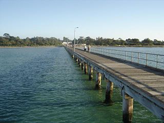
Nepean Highway is a major highway in Victoria, running south from St Kilda Junction in inner-southern Melbourne to Portsea, tracing close to the eastern shore of Port Phillip for the majority of its length. It is the primary road route from central Melbourne through Melbourne's southern suburbs. This name covers a few consecutive roads and is not widely known to most drivers except for its central section, as the entire allocation is still best known by the names of its constituent parts: St Kilda Road, Brighton Road and Nepean Highway proper, and Point Nepean Road. This article will deal with the entire length of the corridor for sake of completion, as well to avoid confusion between declarations.

The Onondaga Limestone is a group of hard limestones and dolomites of Devonian age that form an important geographic feature in some areas in which it outcrops; in others, especially its Southern Ontario portion, the formation can be less prominent as a local surface feature.

"The Rip", also known as "The Heads", is the narrow waterway entrance connecting the Bass Strait to the bay of Port Phillip in southern Victoria, Australia, and is the only route of maritime transport into Port Phillip and thus seaport access into Melbourne and Geelong, Victoria's two largest cities. Because of large tidal flows through the relatively narrow channel from the bay to the ocean, and a high rocky seabed, The Rip is a dangerous stretch of water and has claimed numerous ships and many lives. Geographically, it is the roughly triangular area of water between the land points of Point Nepean on the Mornington Peninsula, Shortlands Bluff and Point Lonsdale on the Bellarine Peninsula, with these three forming The Heads.

McCrae is a suburb on the Mornington Peninsula in Melbourne, Victoria, Australia, 59 km (37 mi) south of Melbourne's Central Business District, located within the Shire of Mornington Peninsula local government area. McCrae recorded a population of 3,311 at the 2021 census.
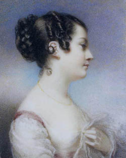
Georgiana Huntly McCrae was an English-Australian painter and diarist.
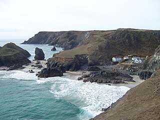
Kynance Cove is a cove on the eastern side of Mount's Bay, Cornwall, England. It is situated on the Lizard peninsula approximately two miles (3 km) north of Lizard Point. The cove became popular in the early Victorian era, with many distinguished visitors including Queen Victoria and Prince Albert and the poets Alfred Tennyson and Algernon Swinburne. The BBC has described Kynance Cove as "one of the most beautiful stretches of coastline in the South West". The South West Coast Path, which follows the coast of south west England from Somerset to Dorset passes by on the cliffs overlooking the cove.

The Cape Fold Belt is a fold and thrust belt of late Paleozoic age, which affected the sequence of sedimentary rock layers of the Cape Supergroup in the southwestern corner of South Africa. It was originally continuous with the Ventana Mountains near Bahía Blanca in Argentina, the Pensacola Mountains, the Ellsworth Mountains and the Hunter-Bowen orogeny in eastern Australia. The rocks involved are generally sandstones and shales, with the shales persisting in the valley floors while the erosion resistant sandstones form the parallel ranges, the Cape Fold Mountains, which reach a maximum height of 2325 m at Seweweekspoortpiek.
The Shire of Flinders was a local government area encompassing the extremity of the Mornington Peninsula, about 65 kilometres (40 mi) south of Melbourne, the state capital of Victoria, Australia. The shire covered an area of 324 square kilometres (125.1 sq mi), and existed from 1874 until 1994.

Port Phillip, sometimes referred to as Port Phillip Bay, is a large bay in southern Victoria, Australia, 1,930 km² in area, with a coastline length of 264 km (164 mi). The bay is extremely shallow for its size, but mostly navigable. The deepest portion is only 24 m, and half the region is shallower than 8 m. Its volume is around 25 km³. The city of Melbourne is located at its northern end, near the mouth of the Yarra River.

Port Phillip is in Victoria, Australia. It has many beaches, most of which are flat, shallow and long, with very small breaks making swimming quite safe. This attracts many tourists, mostly families, to the beaches of Port Phillip during the summer months and school holidays. Water sports such as body boarding and swimming are common, though waves are very rarely large enough for surfing. A number of lifesaving clubs operate along Port Phillip’s beaches.
McCrae Homestead is an historic property located in McCrae, Victoria, Australia. It was built at the foot of Arthurs Seat, a small mountain, near the shores of Port Phillip in 1844 by Andrew McCrae, a lawyer, and his wife Georgiana Huntly McCrae, a portrait artist of note. The homestead is under the care of the National Trust of Australia, and is open to the public. Volunteers who are knowledgeable about the history of the house conduct tours and answer questions.
Mark Nicholson was a pastoralist and politician in colonial Victoria, a member of the Victorian Legislative Council.