Related Research Articles

The Denali Borough is a borough located in the U.S. state of Alaska. As of the 2020 census the population of the borough was 1,619, down from 1,826 in 2010. The borough seat and most populated community is Healy, and its only incorporated place is Anderson. The borough was incorporated in December 1990.

Canton is a town in Oxford County, Maine, United States. Canton is included in the Lewiston-Auburn, Maine metropolitan New England city and town area. The population was 1,125 at the 2020 census. Located beside Lake Anasagunticook, Canton is a summer recreational area.

The Susitna River is a 313-mile (504 km) long river in the Southcentral Alaska. It is the 15th largest river in the United States, ranked by average discharge volume at its mouth. The river stretches from the Susitna Glacier to Cook Inlet's Knik Arm.
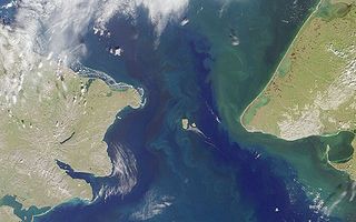
Big Diomede Island or Tomorrow Island is the western island of the two Diomede Islands in the middle of the Bering Strait. The island is a part of the Chukotsky District of the Chukotka Autonomous Okrug of Russia. The border separating Russia and the United States runs north–south between the Diomede Islands.

The Chukchi Sea, sometimes referred to as the Chuuk Sea, Chukotsk Sea or the Sea of Chukotsk, is a marginal sea of the Arctic Ocean. It is bounded on the west by the Long Strait, off Wrangel Island, and in the east by Point Barrow, Alaska, beyond which lies the Beaufort Sea. The Bering Strait forms its southernmost limit and connects it to the Bering Sea and the Pacific Ocean. The principal port on the Chukchi Sea is Uelen in Russia. The International Date Line crosses the Chukchi Sea from northwest to southeast. It is displaced eastwards to avoid Wrangel Island as well as the Chukotka Autonomous Okrug on the Russian mainland.
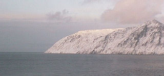
Cape Prince of Wales is the westernmost mainland point of the Americas. It was named in 1778 by Captain James Cook of the British Royal Navy, presumably for the Prince of Wales at the time, George Augustus Frederick. Discovered in 1732, by an expedition led by a Russian military geodesist Mikhail Gvozdev in Sviatoi Gavriil ; later, the cape was named by Vitus Bering for Gvozdev as Mys Gvozdeva. The Yupik name of the cape, published by Gavril Sarychev in 1826, was Nykhta. The current name was approved by a decision of the U.S. Board on Geographic Names in 1944.

The Seward Peninsula is a large peninsula on the western coast of the U.S. state of Alaska whose westernmost point is Cape Prince of Wales. The peninsula projects about 200 mi (320 km) into the Bering Sea between Norton Sound, the Bering Strait, the Chukchi Sea, and Kotzebue Sound, just below the Arctic Circle. The entire peninsula is about 210 mi (330 km) long and 90–140 mi (145–225 km) wide. Like Seward, Alaska, it was named after William H. Seward, the United States Secretary of State who fought for the U.S. purchase of Alaska.

Kotzebue Sound is an arm of the Chukchi Sea in the western region of the U.S. state of Alaska. It is on the north side of the Seward Peninsula and bounded on the east by the Baldwin Peninsula. It is 100 miles (160 km) long and 70 miles (110 km) wide.

The Kasegaluk Lagoon (Iñupiaq: Qasigialik) is a coastal lagoon located in the western part of the North Slope of Alaska. It is separated from the Chukchi Sea by a series of long, thin barrier islands that stretch south and north-east from the town of Point Lay and westwards down to Icy Cape. There are seven passes through these islands. The lagoon receives the waters from the Kukpowruk, Kokolik, and Utukok Rivers.

Hinchinbrook Island is an island in the Gulf of Alaska lying at the entrance to Prince William Sound in the state of Alaska, United States. The island has a land area of 171.98 sq mi (445.438 km²), making it the 37th largest island in the United States. There was a population of five permanent residents as of the 2000 census.
Sunset Beach is a hamlet in the town of Wilson in Niagara County, New York, United States.

Cape Muzon is a cape located in the Alexander Archipelago of the U.S. state of Alaska. It is the southernmost point of Dall Island and the headland marking the northwestern extremity of the Dixon Entrance. The boundary line separating Alaska from Canada runs very close to Cape Muzon, although according to the Alaska Boundary Treaty Cape Muzon is defined precisely as the western end of the so-called A-B Line, part of the Canada–United States border.
Bell Island is an island in the Alexander Archipelago in Southeast Alaska, United States. It is 14 kilometres (8.7 mi) long, lying in Behm Canal, north of Revillagigedo Island. George Vancouver first visited the island on August 12, 1793, in the evening dining on its south coast. He suspected that it was an island, but this was not proven until later in the same month, when Joseph Whidbey, master of HMS Discovery, charted its entire coastline. Vancouver later named it "Bell's Island" after one of his crew, Midshipman Bell.
Kadleroshilik Pingo is a pingo located about 40 kilometers (25 mi) southeast of Prudhoe Bay in the U.S. state of Alaska. Rising to an elevation of 54 meters (178 ft) above the surrounding lake plain, it is the highest known pingo in the world.
Stemm is an unincorporated community in Lawrence County, Indiana, in the United States.
Sully is an unincorporated community in Randolph County, in the U.S. state of West Virginia.
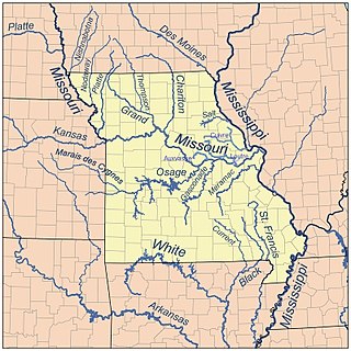
Auxvasse Creek is a stream in north and northeast Callaway County, Missouri. Auxvasse Creek is a tributary to the Missouri River.
Richland Creek is a stream in Callaway County in the U.S. state of Missouri. It is a tributary of Crows Fork Creek. The stream headwaters arise just south of Interstate 70 north of the community of Earl at 38°57′25″N92°02′44″W. The stream flows southeast and crosses under Missouri Route 54 north of Fulton and reaches its confluence with Maddox Branch to form Crows Fork Creek northeast of Fulton at 38°53′16″N91°53′39″W.
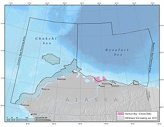
Harrison Bay is an estuary located north of Alaska that opens into the Beaufort Sea. It is adjacent to the Colville Delta. The powerful outflow of the Colville River creates a shallow region that is rich with nutrients, making it ecologically significant for wildlife.
References
- ↑ U.S. Geological Survey Geographic Names Information System: Anxiety Point
- ↑ Hook, J. N. (10 June 2014). All Those Wonderful Names. Open Road Media. p. 234. ISBN 978-1-4976-1186-3.
- ↑ Orth, Donald J. (1967). Dictionary of Alaska Place Names. U.S. Government Printing Office. p. 83.
70°18′55″N147°57′25″W / 70.31528°N 147.95694°W
| | This article about a location in the North Slope Borough, Alaska is a stub. You can help Wikipedia by expanding it. |