Apere River

Last updated
Apere River
Country Bolivia
Physical characteristics
Lengthc. 500 km (310 mi)

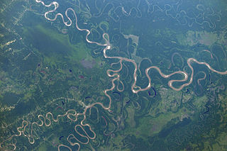
The Apere River is a river of Bolivia. It is a tributary of the Mamoré River, in the Department of Beni.

Bolivia country in South America

Bolivia, officially the Plurinational State of Bolivia is a landlocked country located in western-central South America. The capital is Sucre while the seat of government and financial center is located in La Paz. The largest city and principal industrial center is Santa Cruz de la Sierra, located on the Llanos Orientales a mostly flat region in the east of Bolivia.

Tributary stream or river that flows into a main stem river or lake

A tributary or affluent is a stream or river that flows into a larger stream or main stem river or a lake. A tributary does not flow directly into a sea or ocean. Tributaries and the main stem river drain the surrounding drainage basin of its surface water and groundwater, leading the water out into an ocean.

Mamoré River river

The Mamoré is a large river in Bolivia and Brazil which unites with the Beni to form the Madeira, one of the largest tributaries of the Amazon. It rises on the northern slope of the Sierra de Cochabamba, east of the city of Cochabamba, and is known as the Chimoré down to its junction with the Chapare. Its larger tributaries are the Chapare, Secure, Apere, and Yacuma from the west, and the Ichilo, Guapay, Ivari, Manique and Guapore from the east. Taking into account its length only, the Guapay should be considered the upper part of the Mamore; but it is shallow and obstructed, and carries a much smaller volume of water. The Guapore also rivals the Mamore in length and volume, having its source in the Parecis plateau, Mato Grosso, Brazil, a few miles from streams flowing north-ward to the Tapajos and Amazon, and southward to the Paraguay and Paraná rivers. The Mamore is interrupted by rapids a few miles above its junction with the Beni, but a railway 300 km long has been undertaken from below the rapids of the Madeira. Above the rapids the river is navigable to Chimore, at the foot of the sierra, and most of its tributaries are navigable for long distances. In 1874, Franz Keller gave the outflow of the Mamoré at mean water level, and not including the Guapore, as 41,459 cm3/sec, and the area of its drainage basin, also not including the Guapore, as 24,299 km2.

See also

Related Research Articles

Chapare Province province of Bolivia

Chapare, also called The Chapare and is pronounced Cha-pa-reh, is a rural province in the northern region of Cochabamba Department in central Bolivia. The majority of the territory consists of valley rainforests that surround the area's main waterway, the Chapare River, which is also a tributary of the Amazon River. The provincial capital is Sacaba, 11 km east of Cochabamba, its principal town is Villa Tunari, a popular tourist destination.

Mizque Province Province in Cochabamba, Bolivia

Mizque is a province in the Cochabamba Department, Bolivia. Its capital is Mizque.

Quillacollo Province Province in Cochabamba Department, Bolivia

Quillacollo is a province in the Cochabamba Department, Bolivia. It is known for its festival in August where people from all over Bolivia come and pay homage to the Virgin of Urqupiña. Quillacollo is said to be one of the fastest growing cities in Bolivia.

Bernardino Bilbao Province province of Bolivia

Bernardino Bilbao is a province in the Northern parts of the Bolivian department of Potosí. It has its name after Bernardino Bilbao Rioja, Bolivian general and politician.

Rafael Bustillo Province Province in Potosí Department, Bolivia

Rafael Bustillo is a province in the Bolivian Potosí Department. Its name honors the Bolivian diplomat and foreign secretary Rafael Bustillo. The capital of the province is Uncía with a population of 5,709 in the year 2001, the largest town is Llallagua with 20,065 inhabitants.

Riberalta Town and municipality in Beni Department, Bolivia

Riberalta is a town in the Beni Department in northern Bolivia, situated where the Madre de Dios River joins the Beni River. Riberalta is on the south bank of the Beni River.

Río Grande (Bolivia) river in Bolivia

The Río Grande in Bolivia rises on the southern slope of the Cochabamba mountains, east of the city Cochabamba, at 17°26′11″S65°52′22″W. At its source it is known as the Rocha River. It crosses the Cochabamba valley basin in a westerly direction. After 65 km the river turns south east and after another 50 km joins the Arque River at 17°42′10″S66°14′45″W and an elevation of 2.350 m.

Millennium Park (Calgary) skatepark in Calgary, Alberta, Canada

Millennium Park is a skatepark in Calgary, Alberta. It was built on the western end of downtown Calgary, on the site of the former Mewata Stadium adjacent to Mewata Armouries.

Santa Rosa de Yacuma Place in Beni Department, Bolivia

Santa Rosa de Yacuma or Santa Rosa del Yacuma is a small town in the Amazon pampas of the Bolivian Beni Department.

Dundee, Quebec Township municipality in Quebec, Canada

Dundee is a township municipality in Le Haut-Saint-Laurent Regional County Municipality in the Montérégie administrative region of Quebec, Canada. At the Canada 2011 Census, the population was 408. It is primarily an agricultural area consisting of dairy and grain farms.

The Cotacajes River is a river of Bolivia.

Spedden

Spedden is a hamlet in central Alberta, Canada within Smoky Lake County. It is located 0.3 kilometres (0.19 mi) north of Highway 36, approximately 106 kilometres (66 mi) southwest of Cold Lake. It was named after one of the original surveyors who died in the area in 1919. Previously it was Cache Lake.

Arque Municipality Municipality in Cochabamba Department, Bolivia

Arque Municipality is the first municipal section of the Arque Province in the Cochabamba Department, Bolivia. Its seat is Arque. At the time of census 2001 the municipality had 11,806 inhabitants. It has the lowest HDI of Bolivia with 0.311.

Morochata Municipality is the second municipal section of the Ayopaya Province in the Cochabamba Department, Bolivia. Its seat is Morochata.

Tolata Municipality Municipality in Cochabamba Department, Bolivia

Tolata Municipality is the third municipal section of the Germán Jordán Province in the Cochabamba Department, Bolivia. Its seat is Tolata.

El Empalme Canton Canton in Guayas Province, Ecuador

El Empalme Canton is a canton of Ecuador, located in the Guayas Province. Its capital is the town of El Empalme. Its population at the 2001 census was 64,789.

Colquechaca Town in Potosí Department, Bolivia

Colquechaca is a small town in Bolivia. In 2009 it has an estimated population of 1,753. It is the highest city in Bolivia, at 4,170 metres (13,680 ft) above sea level, with residences up to 4,235 metres (13,894 ft).

Alanganallur taluka is a taluka in the Madurai district of Tamil Nadu, India. It has a total of thirty-seven panchayat villages. It has the same name and boundaries as the revenue block.

Dragoon Wash, a stream tributary to the San Pedro River, in Cochise County, Arizona. It has its source just southwest of the town of Dragoon. 32°01′21″N110°02′46″W It runs southwesterly to meet the San Pedro River.

Ellis is an unincorporated community in Muskingum County, in the U.S. state of Ohio.

References

Coordinates: 15°43′32″S66°2′46″W / 15.72556°S 66.04611°W / -15.72556; -66.04611

Geographic coordinate system Coordinate system

A geographic coordinate system is a coordinate system that enables every location on Earth to be specified by a set of numbers, letters or symbols. The coordinates are often chosen such that one of the numbers represents a vertical position and two or three of the numbers represent a horizontal position; alternatively, a geographic position may be expressed in a combined three-dimensional Cartesian vector. A common choice of coordinates is latitude, longitude and elevation. To specify a location on a plane requires a map projection.