
West Virginia is a landlocked state in the Southern and Mid-Atlantic regions of the United States. It is bordered by Pennsylvania and Maryland to the northeast, Virginia to the southeast, Kentucky to the southwest, and Ohio to the northwest. West Virginia is the 10th-smallest state by area and ranks as the 12th-least populous state, with a population of 1,793,716 residents. The capital and most populous city is Charleston with a population of 49,055.

The Appalachian Mountains, often called the Appalachians, are a mountain range in eastern to northeastern North America. The term "Appalachian" refers to several different regions associated with the mountain range, and its surrounding terrain. The general definition used is one followed by the United States Geological Survey and the Geological Survey of Canada to describe the respective countries' physiographic regions. The U.S. uses the term Appalachian Highlands and Canada uses the term Appalachian Uplands; the Appalachian Mountains are not synonymous with the Appalachian Plateau, which is one of the provinces of the Appalachian Highlands.

Appalachia is a geographic region located in the central and southern sections of the Appalachian Mountains of the eastern United States. In the north, its boundaries stretch from the western Catskill Mountains of New York, continuing south through the Blue Ridge Mountains and Great Smoky Mountains into northern Georgia, Alabama, and Mississippi, with West Virginia near the center, being the only state entirely within the boundaries of Appalachia. In 2021, the region was home to an estimated 26.3 million people.
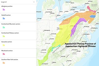
The Appalachian Plateau is a series of rugged dissected plateaus located on the western side of the Appalachian Mountains. The Appalachian Mountains are a range that run from Nova Scotia in Canada to Alabama in the United States.

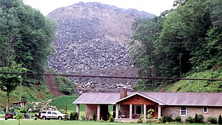
Mountaintop removal mining (MTR), also known as mountaintop mining (MTM), is a form of surface mining at the summit or summit ridge of a mountain. Coal seams are extracted from a mountain by removing the land, or overburden, above the seams. This process is considered to be safer compared to underground mining because the coal seams are accessed from above instead of underground. In the United States, this method of coal mining is conducted in the Appalachian Mountains in the eastern United States. Explosives are used to remove up to 400 vertical feet of mountain to expose underlying coal seams. Excess rock and soil is dumped into nearby valleys, in what are called "holler fills" or "valley fills".

Surface mining, including strip mining, open-pit mining and mountaintop removal mining, is a broad category of mining in which soil and rock overlying the mineral deposit are removed, in contrast to underground mining, in which the overlying rock is left in place, and the mineral is removed through shafts or tunnels.

The Appalachian Regional Commission (ARC) is a United States federal–state partnership that works with the people of Appalachia to create opportunities for self-sustaining economic development and improved quality of life. Congress established ARC to bring the region into socioeconomic parity with the rest of the nation.
Appalshop is a media, arts, and education center located in Whitesburg, Kentucky, in the heart of the southern Appalachian region of the United States.

The history of West Virginia stems from the 1861 Wheeling Convention, which was an assembly of northwestern Southern Unionist from northwestern counties of the state of Virginia. They aimed to repeal the Ordinance of Secession that Virginia made at the start of the American Civil War (1861–1865). West Virginia was formed and recognized by the U.S. Congress on June 20, 1863, and protected by the U.S. Army.
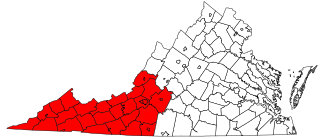
Southwest Virginia, often abbreviated as SWVA, is a mountainous region of Virginia in the westernmost part of the commonwealth. Located within the broader region of western Virginia, Southwest Virginia has been defined alternatively as all Virginia counties on the Appalachian Plateau, all Virginia counties west of the Eastern Continental Divide, or at its greatest expanse, as far east as Blacksburg and Roanoke. Another geographic categorization of the region places it as those counties within the Tennessee River watershed. Regardless of how borders are drawn, Southwest Virginia differs from the rest of the commonwealth in that its culture is more closely associated with Appalachia than the other regions of Virginia. Historically, the region has been and remains a rural area, but in the 20th century, coal mining became an important part of its economy. With the decline in the number of coal jobs and the decline of tobacco as a cash crop, Southwest Virginia is increasingly turning to tourism as a source of economic development. Collectively, Southwest Virginia's craft, music, agritourism and outdoor recreation are referred to as the region's "creative economy."

In the United States, the Hillbilly Highway is the out-migration of Appalachians from the Appalachian Highlands region to industrial cities in northern, midwestern, and western states, primarily in the years following World War II in search of better-paying industrial jobs and higher standards of living. Many of these migrants were formerly employed in the coal mining industry, which started to decline in 1940s. The word hillbilly refers to a negative stereotype of people from Appalachia. The term hillbilly is considered to be a modern term because it showed up in the early 1900s. Though the word is Scottish in origin, it does not derive from dialect. In Scotland, the term hill-folk referred to people who preferred isolation from the greater society and the term billy referred to someone being a "companion" or "comrade". The Hillbilly Highway was a parallel to the better-known Great Migration of African-Americans from the south.
Appalachian Voices is an American environmental organization. Their stated environmental concerns include eliminating air pollution, ending mountaintop removal, cleaning up coal ash pollution and promoting renewable energy and energy efficiency.
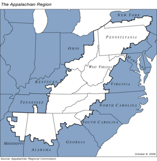
Appalachia is a geographic region of the Eastern United States. Home to over 25 million people, the region includes mountainous areas of 13 states: Mississippi, Alabama, Pennsylvania, New York, Georgia, South Carolina, North Carolina, Tennessee, Virginia, Kentucky, Ohio, Maryland, as well as the entirety of West Virginia.
Land is owned in Canada by governments, Indigenous groups, corporations, and individuals. Canada is the second-largest country in the world by area; with 9,093,507 km2 (3,511,023 sq mi) of land.

The Appalachian region has always had to allocate much resources and time into transportation due to the region's notable and unique geography. Mountainous terrain and commonly occurring adverse weather effects such as heavy fog and snowfall made roads hazardous and taxing on the traveling vehicles. Initially, European settlers found gaps in the mountains, among them the Cumberland Gap and the Wilderness Road. Another notable challenge of Appalachian travel is the political elements of constructing transportation routes. Most travel systems are funded by municipalities, but since The Appalachian area has several different states it can be difficult for the various governments to agree on how to work on transportation. The most influential forms of travel in the Appalachian region are based on water trading routes, roads and railroads.

The Appalachian region and its people have historically been stereotyped by observers, with the basic perceptions of Appalachians painting them as backwards, rural, and anti-progressive. These widespread, limiting views of Appalachia and its people began to develop in the post-Civil War; Those who "discovered" Appalachia found it to be a very strange environment, and depicted its "otherness" in their writing. These depictions have persisted and are still present in common understandings of Appalachia today, with a particular increase of stereotypical imagery during the late 1950s and early 1960s in sitcoms. Common Appalachian stereotypes include those concerning economics, appearance, and the caricature of the "hillbilly."

The Western Allegheny Plateau is an ecoregion of the Temperate broadleaf and mixed forests Biome, located on the western Allegheny Plateau and in the Appalachia region of the Eastern United States.
Environmental justice and coal mining in Appalachia is the study of environmental justice – the interdisciplinary body of social science literature studying theories of the environment and justice; environmental laws, policies, and their implementations and enforcement; development and sustainability; and political ecology – in relation to coal mining in Appalachia.

Environmental issues in Appalachia, a cultural region in the Eastern United States, include long term and ongoing environmental impact from human activity, and specific incidents of environmental harm such as environmental disasters related to mining. A mountainous area with significant coal deposits, many environmental issues in the region are related to coal and gas extraction. Some extraction practices, particularly surface mining, have met significant resistance locally and at times have received international attention.
The city of Baltimore, Maryland includes a significant Appalachian population. The Appalachian community has historically been centered in the neighborhoods of Hampden, Pigtown, Remington, Woodberry, Lower Charles Village, Highlandtown, and Druid Hill Park, as well as the Baltimore inner suburbs of Dundalk, Essex, and Middle River. The culture of Baltimore has been profoundly influenced by Appalachian culture, dialect, folk traditions, and music. People of Appalachian heritage may be of any race or religion. Most Appalachian people in Baltimore are white or African-American, though some are Native American or from other ethnic backgrounds. White Appalachian people in Baltimore are typically descendants of early English, Irish, Scottish, Scotch-Irish, and Welsh settlers. A migration of White Southerners from Appalachia occurred from the 1920s to the 1960s, alongside a large-scale migration of African-Americans from the Deep South and migration of Native Americans from the Southeast such as the Lumbee and the Cherokee. These out-migrations caused the heritage of Baltimore to be deeply influenced by Appalachian and Southern cultures.
