
Communications in Gibraltar comprise a wide range of telephony systems, Internet access, broadcasting and satellite control. There is also printed and online media. Regulation of telecommunications and broadcasting are the responsibility of the Gibraltar Regulatory Authority (GRA), established by means of the Gibraltar Regulatory Authority Act in 2000.
Transportation in Gibraltar includes roadway, bus, air, aerial cable car and sea. Due to Gibraltar's compact size and density, walking is the most popular mode of transport making up 48% of trips. Private vehicles make up 30% of trips while a further 15% of trips are made on motorcycles or mopeds.
The governor of Gibraltar is the representative of the British monarch in the British overseas territory of Gibraltar. The governor is appointed by the monarch on the advice of the British government. The role of the governor is to act as the de facto head of state. They are responsible for formally appointing the chief minister of Gibraltar, along with other members of the government of Gibraltar after a general election. The governor serves as commander-in-chief of Gibraltar's military forces and has sole responsibility for defence and security. Although recent appointments have all been former military personnel, most being former Royal Navy or Royal Marines flag officers, Sir James Dutton resigned from the role in 2015, complaining that it was "more representational and ceremonial than I had expected".

Europa Point is the southernmost point of Gibraltar. Although not the southernmost point of the Iberian Peninsula, Europa Point defines the boundary between the Straits of Gibraltar in the Atlantic Ocean, and the Alboran Sea within the Mediterranean. At the end of the Rock of Gibraltar, the area is flat and occupied by such features as a playing field and a few buildings. On a clear day, views of North Africa can be seen across the Strait of Gibraltar including Ceuta and the Rif Mountains of Morocco; as well as the Bay of Gibraltar and the Spanish towns along its shores. It is reached from the old town by Europa Road.
The Gibraltar Defence Police (GDP) is a civil police force which provides a policing and security service for the Ministry of Defence in Gibraltar. Prior to 17 December 2009 it was known as the Gibraltar Services Police (GSP).

Northumbrian Water Group plc (NWG) is the holding company for several companies in the water supply, sewerage and waste water industries. Its largest subsidiary is Northumbrian Water Limited (NWL), which is one of ten companies in England and Wales that are regulated water supply and sewerage utilities. NWL is the principal water supplier in the north-east of England, where it trades as Northumbrian Water, and also supplies water to part of eastern England, as Essex and Suffolk Water. In 2011 it was acquired by Cheung Kong Infrastructure Holdings.
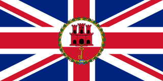
Gibraltar is a British Overseas Territory and city located at the southern tip of the Iberian Peninsula, on the Bay of Gibraltar, near the exit of the Mediterranean Sea into the Atlantic Ocean. It has an area of 6.8 km2 (2.6 sq mi) and is bordered to the north by Spain. The landscape is dominated by the Rock of Gibraltar, at the foot of which is a densely populated town area, home to some 34,003 people, primarily Gibraltarians.

Gibdock is a shipyard in the British overseas territory of Gibraltar. It formerly operated as a Royal Navy Dockyard.

Originally from the Atlas Mountains and the Rif Mountains of Morocco, the Barbary macaque population in Gibraltar is the only wild monkey population on the European continent. Although most Barbary monkey populations in Africa are experiencing decline due to hunting and deforestation, the Gibraltar population is increasing. As of 2020, some 300 animals in five troops occupy the Upper Rock area of the Gibraltar Nature Reserve, though they make occasional forays into the town. As they are a tailless species, they are also known locally as Barbary apes or rock apes, despite being classified as monkeys. Spanish speakers simply refer to them as monos when conversing in Spanish, although English is the native language as the area is a British overseas territory.
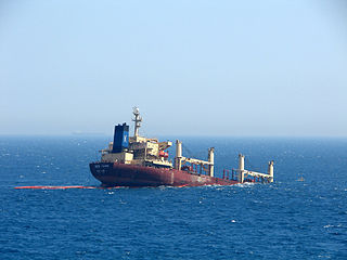
MV New Flame was a Panamanian bulk-carrier cargo ship. It collided with an oil tanker off Europa Point, the southernmost tip of Gibraltar on 12 August 2007, and ended up partially submerged in the Strait of Gibraltar. The vessel broke into two in December 2007 amid numerous unsuccessful recovery efforts. The cargo was salvaged and the stern section removed for scrap. Following the crew's rescue, the captain was arrested for having departed without authorisation. Charges of endangering shipping were later dropped.
The following outline is provided as an overview of and topical guide to Gibraltar:
Gibtelecom is the largest telecommunications provider in the British overseas territory of Gibraltar. Its headquarters is located on John Mackintosh Square.
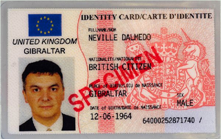
The Gibraltar identity card is an official identity document issued by Civil Status and Registration Office of the Government of Gibraltar to all British citizens living in Gibraltar. Validity of the document is 10 years.

The South Mole is a breakwater located in the southern section of Gibraltar Harbour, in the British Overseas Territory of Gibraltar, at the southern end of the Iberian Peninsula. Previously known as the New Mole and New Mole Extension, the South Mole, with the rest of harbour, is just north of the east entrance to the Strait of Gibraltar.

The Detached Mole is a breakwater located at the western aspect of the middle section of Gibraltar Harbour, in the British Overseas Territory of Gibraltar, at the southern end of the Iberian Peninsula. The Detached Mole, with the rest of harbour, is just north of the east entrance to the Strait of Gibraltar and was the site of the Detached Mole Battery. In addition to the role the breakwater plays in the defence of and access to the harbour, the Detached Mole provides berths for ships. The area adjacent to the mole is also a source of recreational and research opportunities, with dive sites at the wrecks of sunken ships.
The Rosia Water Tanks were large water tanks built at the turn of the nineteenth century at Rosia Bay in the British Overseas Territory of Gibraltar. They were constructed based on the recommendation by Admiral John Jervis, 1st Earl of St Vincent that the Victualling Yard complex be relocated to Rosia Bay. The complex allowed Royal Navy vessels to obtain both food and water at one site. The Rosia Water Tanks remained in the possession of the Ministry of Defence until 2004, at which time they were transferred to the Government of Gibraltar. Despite local and international criticism, and a court case brought by the Gibraltar Heritage Trust, the tanks were demolished in 2006 to make way for affordable housing. When developer OEM International's funding proved insufficient to complete the project the government repossessed the site.
St. Jago's Cemetery was a cemetery in the British Overseas Territory of Gibraltar. Also known as Deadman's Cemetery, it was positioned just north of the Charles V Wall. The burial ground was initially used for the poor Spaniards of La Turba; following the 1704 capture of Gibraltar, it was utilised as a Protestant cemetery. In 1929, the burial ground was incorporated into the St. Jago's Barracks recreational facilities. Three years later, some of the remaining headstones were transferred to Trafalgar Cemetery. Little evidence of the former cemetery remains. It is notable as the earliest cemetery in Gibraltar as well as the only one within the city limits.

Nun's Well is an ancient underground water reservoir in the British Overseas Territory of Gibraltar. It is located at Europa Point, and is thought to be of the Moorish period. It represents some of the earliest evidence of an artificial water supply in Gibraltar. The name of the cistern is thought to be derived from the nuns associated with the Shrine of Our Lady of Europe. In the eighteenth century, Nun's Well supplied the military with water. In the early nineteenth century, it provided water for the brewery that was built next door. In 1988, the Royal Engineers constructed what is now the main building, which has a castle-like appearance. Nun's Well became the focus of controversy during the 2010-2011 restoration of the site.

Town Range is a major road in the British Overseas Territory of Gibraltar. It is located in the old town area and runs parallel to Main Street and part of Prince Edward's Road. It is also known in Spanish as Calle Cuartel, in reference to the barracks constructed on the street in 1740. It is one of the three main parallel streets in the old town and is likely to date back to the Moorish period. Until the mid-19th century it was notorious for its filthiness due to wholly inadequate sanitation and lack of any running water supply. It was the point of outbreak of Gibraltar's devastating 1804 epidemic of yellow fever, which killed a third of the territory's population. The street is now a residential and commercial area notable for several important public buildings in addition to the old Georgian barracks, which have been converted for civilian use.

Water supply and sanitation in Gibraltar have been major concerns for its inhabitants throughout its history, from medieval times to the present day. The climate of Gibraltar is a mild Mediterranean one with warm dry summers and cool wet winters. Since daily records of rainfall began in 1790, annual rainfall has averaged a mean of 838 millimetres (33.0 in) with the highest volumes in December and the lowest in July. However, most of Gibraltar's small land area is occupied by the Rock of Gibraltar, a limestone outcrop that is riddled with caves and crevices. There are no rivers, streams, or large bodies of water on the peninsula, which is connected to Spain via a narrow sandy isthmus.