Cusco or Cuzco is a city in southeastern Peru near the Sacred Valley of the Andes mountain range and the Huatanay river. It is the capital of the Department of Cusco and of the Cusco Province. The city is the seventh most populous in Peru; in 2017, it had a population of 428,450. Its elevation is around 3,400 m (11,200 ft).

Peru, officially the Republic of Peru, is a country in western South America. It is bordered in the north by Ecuador and Colombia, in the east by Brazil, in the southeast by Bolivia, in the south by Chile, and in the south and west by the Pacific Ocean. Peru is a megadiverse country with habitats ranging from the arid plains of the Pacific coastal region in the west to the peaks of the Andes mountains extending from the north to the southeast of the country to the tropical Amazon basin rainforest in the east with the Amazon River. Peru has a population of over 32 million, and its capital and largest city is Lima. At 1,285,216 km2, Peru is the 19th largest country in the world, and the third largest in South America.
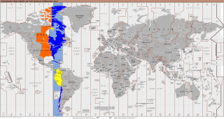
UTC−05:00 is an identifier for a time offset from UTC of −05:00. In North America, it is observed in the Eastern Time Zone during standard time, and in the Central Time Zone during the other eight months. The western Caribbean uses it year round.

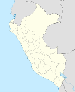
Cusco, also spelled Cuzco, is a department and region in Peru and is the fourth largest department in the country, after Madre de Dios, Ucayali, and Loreto. It borders the departments of Ucayali on the north; Madre de Dios and Puno on the east; Arequipa on the south; and Apurímac, Ayacucho and Junín on the west. Its capital is Cusco, the historical capital of the Inca Empire.

A visitor center or centre, visitor information center or tourist information centre is a physical location that provides information to tourists.

Peru has many languages in use, with its official languages being Spanish, Quechua and Aymara. Spanish has been in the country since it began being taught in the time of José Pardo instead of the country's Native languages, especially the languages in the Andes. In the beginning of the 21st century, it was estimated that in this multilingual country, about 50 very different and popular languages are spoken: which reduces to 44 languages if dialects are considered variants of the same language. The majority of these languages are Indigenous, but the most common language is Spanish, the main language that about 94.4% of the population speaks. Spanish is followed by the country's Indigenous languages, especially all types of Quechua and Aymara (1.7%), who also have co-official status according to Article 48 of the Constitution of Peru, as well as the languages of the Amazon and the Peruvian Sign Language. In urban areas of the country, especially the coastal region, most people are monolingual and only speak Spanish, while in many rural areas of the country, especially in the Amazon, multilingual populations are prevalent.
Inca Manco Cápac International Airport, known as Aeropuerto Internacional Inca Manco Cápac in Spanish, is an extremely high elevation airport serving in the city of Juliaca in Peru, 32 kilometres (20 mi) west of Titicaca Lake. Airport operations are run by Corporación Peruana de Aeropuertos y Aviación Comercial S.A. (CORPAC), a government entity that oversees management of Peruvian airports. Despite being classified as international, the airport does not feature any scheduled international nonstop flights. The airport has one of the longest runways in Latin America and the longest in Peru.
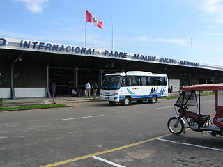
Padre Aldamiz International Airport, also known as Puerto Maldonado International Airport, is an airport serving the city of Puerto Maldonado in the Madre de Dios Region of Peru. The airport oversees one domestic (national) airline with commercial flights.
Characato is a district of Arequipa Province, Peru. It is located to the southeast of Arequipa, at an average elevation of 3,505 meters above the sea level. As of the year 2022, it had a population of 17,706.

Mayor General FAP Armando Revoredo Iglesias Airport, known in Spanish as Aeropuerto Mayor General FAP Armando Revoredo Iglesias, is an airport serving Cajamarca, capital of the Cajamarca Region in Peru. It is run by CORPAC S.A., a government organization that oversees management of Peruvian airports.

Francisco Carle Airport is a high-elevation regional airport serving Jauja, in the Junin Region of Peru, and surrounding cities such as Huancayo and Tarma. It is served by two scheduled airlines. The airport terminal and runways have undergone expansion to accommodate larger aircraft. Travelers to domestic and international destinations connect in Lima's Jorge Chávez International Airport.
Alférez FAP David Figueroa Fernandini Airport is an airport serving Huánuco, Peru. It is the most important airport in the Huánuco Region in central Peru and is operated by the civil government. It is currently served by 3 airlines, all of them offering daily flights to Lima: ATSA, Star Perú and Wayraperú. Although there are no other regular scheduled services, the airport serves many charter and private flights.
Aramango is a district of the province of Bagua. The first settlers were the families aguarunas, that were located, in what today it is the Principal Park, with the arrival of the colonists in the year 1955 approximately, native these were displaced, sheltering in the first moment in the Native Community of the Reservation Ujucamo and others went to the interior of the forest.
Andajes District is one of six districts of the province Oyón in Peru.
The Petroglyphs of Pusharo constitute a unique and extensive ancient rock art archaeological site in southeastern Peru's Manú National Park, an expanse of rain forest that still contains unexplored and little known areas, and for which an official government permit is required for entry.

Chaupi Orco or Viscachani is a mountain in the Andes on the border of Bolivia and Peru. It has a height of 6,044 metres (19,829 ft). On the Bolivian side it is located in the La Paz Department, Franz Tamayo Province, Pelechuco Municipality, and on the Peruvian side it lies in the Puno Region, Putina Province, Sina District. It lies north of Salluyu. Chaupi Orco is the highest peak of the Apolobamba mountain range.
Pirhuaylla is a 4,158-metre-high (13,642 ft) mountain in the Andes of Peru. It is situated in the Ayacucho Region, Cangallo Province, Paras District, southeast of Paras. The Pampas River flows along its southern slopes. It harbors an archaeological site.
Moyobamba is an airport serving the town of Moyobamba in the San Martín Region of Peru. The runway is just northwest of the town.