Albany County is a county in the state of New York, United States. Its northern border is formed by the Mohawk River, at its confluence with the Hudson River, which is to the east. As of the 2020 United States Census, the population was 314,848. The county seat and largest city is Albany, which is also the state capital of New York. As originally established by the English government in the colonial era, Albany County had an indefinite amount of land, but has had an area of 530 square miles (1,400 km2) since March 3, 1888. The county is named for the Duke of York and of Albany, who became James II of England. The county is part of the Capital District region of the state.
Albany is the capital and oldest city in the U.S. state of New York, and the county seat of and most populous city in Albany County. It is located on the west bank of the Hudson River, about 10 miles (16 km) south of its confluence with the Mohawk River.

Watervliet is a city in northeastern Albany County, New York, United States. The population was 10,375 as of the 2020 census. Watervliet is north of Albany, the capital of the state, and is bordered on the north, west, and south by the town of Colonie. The city is also known as "the Arsenal City".

Colonie is a town in Albany County, New York, United States. It is the most-populous suburb of Albany, and is the third-largest town in area in Albany County, occupying approximately 11% of the county. Several hamlets exist within the town. As of the 2020 census, the town had a total population of 85,590.
Guilderland Center is a hamlet in the town of Guilderland, Albany County, New York, United States. The hamlet lies along New York Route 146 and the Black Creek, a tributary of the Normans Kill.

The neighborhoods of Albany, New York are listed below.

The Ten Broeck Mansion in Albany, New York was built in 1797. It was listed on the National Register of Historic Places in 1971. A decade later it was included as a contributing property to the Arbor Hill Historic District–Ten Broeck Triangle when that neighborhood was listed on the Register.
Watervliet was a town that at its height encompassed most of present-day Albany County and most of the current town of Niskayuna in neighboring Schenectady County, in the state of New York, United States. Just prior to its dissolution, the town encompassed the current towns of Colonie and Green Island and the city of Watervliet.

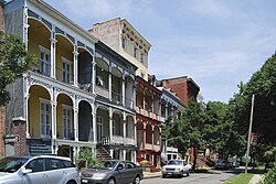
The Clinton Avenue Historic District in Albany, New York, United States, is a 70-acre (28 ha) area along that street between North Pearl and Quail streets. It also includes some blocks along neighboring streets such as Lark and Lexington.
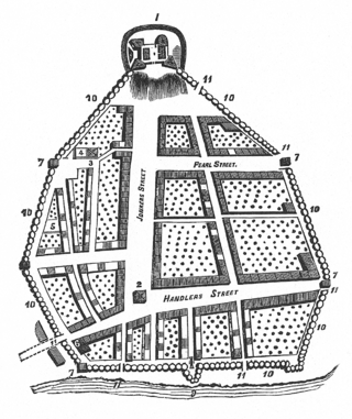
The streets of Albany, New York, have had a long history going back almost 400 years. Many of the streets have changed names over the course of time, some have changed names many times. Some streets no longer exist, others have changed course. Some roads existed only on paper. The oldest streets were haphazardly laid out with no overall plan until Simeon De Witt's 1794 street grid plan. The plan had two grids, one west of Eagle Street and the old stockade, and another for the Pastures District south of the old stockade.
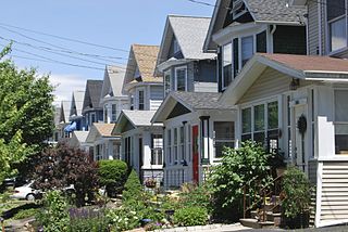
West Albany is a hamlet in the town of Colonie, Albany County, New York, United States. Parts of the neighboring city of Albany around Watervliet Avenue Extension and Industrial Park Road are also considered part of West Albany and includes the majority of the West Albany Rail Yard. The hamlet lies along Albany's northern border and was once home to many industries, including one of the largest cattle stockyards in the United States, a large railroad switching yard, and a Tobin First Prize packing plant. Those industries are gone now and the community is mostly a residential suburb of Albany in the shadow of abandoned industrial complexes. West Albany has historically been ethnically diverse with Polish, Italian, Irish, German, and English immigrants drawn by the 5,000+ jobs at the West Albany Rail Yard. Though the neighborhood is predominately Italian-American, it remains diverse with the Polish American Citizens Club, the West Albany Italian Benevolent Society, the Bet Shraga Hebrew Academy, and a Korean worship center in the former St. Francis de Sales Catholic Church.
Lisha Kill is a hamlet in the town of Colonie, Albany County, New York, United States. Lisha Kill lies on New York Route 5 in the western section of the town. The hamlet received its name from the creek of the same name, Lisha Kill, kill being Dutch for creek or stream. The stream is also referred to as Lisha's Kill and received its name from a local legend about a Native American woman who is buried along its banks.
Mannsville is a hamlet within the town of Colonie, Albany County, New York, United States. It is a small community west of the city of Watervliet and is inaccessible to the rest of Colonie by car without driving through Watervliet. Town historian Jean Olton stated in 1987 that Mannsville was no longer considered "an official hamlet" of the Town of Colonie. As of 2019, Mannsville is listed on the Town of Colonie's Town Historian website as an unincorporated community within the Town of Colonie.

North Albany is a neighborhood in the city of Albany, New York. North Albany was settled in the mid-17th century by the Patroon of Rensselaerswyck and his tenants and later became a hamlet in the town of Watervliet. Due to the Erie Canal being constructed in 1825, North Albany saw immense growth, with the Albany Lumber District and an influx of Irish immigrants lending the area the name of Limerick. Home to many historic warehouses and row houses, North Albany continues to be an important industrial neighborhood. Recent efforts have begun to gentrify the neighborhood by adapting heavy industry/warehouse use to artistic and entertainment venues, such as a German beer garden, an amusement park, live music venues, and arts and crafts marketplaces.

Sheridan Hollow is a neighborhood in Albany, New York located in a ravine north of Downtown Albany. Capitol Hill to the south and Arbor Hill to the north flank the ravine. Often the neighborhood is overlooked by city residents, and outsiders who work in the neighborhood often don't recognize the name of the neighborhood. This is due to the identity of the Hollow being subsumed into its larger neighbor Arbor Hill, for instance news stories of events are often accredited to the wrong neighborhood. Being on undesirable land for development in colonial times, growth was slow in the Hollow and the neighborhood was populated through the centuries by a series of ethnic groups new to Albany, such as the Irish, Polish, and African Americans.

The former Church of the Holy Innocents, later known as Church of the Nativity of our Virgin Lady, was originally an Episcopal church located on North Pearl Street in Albany, New York, United States. It and an adjacent chapel were built in the mid-19th century in an early Gothic Revival style designed by Frank Wills. It was listed on the National Register of Historic Places in 1978.

The Arbor Hill Historic District–Ten Broeck Triangle, originally the Ten Broeck Historic District, is a seven-block area located within the Arbor Hill neighborhood north of what is today downtown Albany, New York, United States. In 1979 its easternmost third, the Ten Broeck Triangle, the second oldest residential neighborhood in the city, was recognized as a historic district and listed on the National Register of Historic Places. Four years later, the district was increased to its current size and renamed to reflect its expansion to include some of the rest of Arbor Hill.

The Broadway–Livingston Avenue Historic District is located at the junction of those two streets in Albany, New York, United States. It includes seven buildings remaining from an original 20, all contributing properties, and a Warren truss railroad bridge. In 1988 the area was recognized as a historic district and listed on the National Register of Historic Places.
The history of Albany, New York, from 1784 to 1860, begins with the ratification of the Treaty of Paris by the Congress of the Confederation in 1784 and ends in 1860, prior to the American Civil War.

The history of Albany, New York from 1860 to 1900 begins in 1860, prior to the start of the Civil War, and ends in 1900.