Related Research Articles

Punggol, old name as Ponggol, is a planning area and new town situated on the Tanjong Punggol peninsula in the North-East Region of Singapore. The town directly borders Sengkang to the south and shares riverine boundaries with the planning area of Seletar to the west and Pasir Ris to the east. Bounding the town to the north and north-east is the Straits of Johor, with Coney Island included as a part of the Punggol planning area.
Woodlands is a planning area and residential town located in the North of Singapore. As of 2019, the town has a population of 254,733. Located approximately 25 km (16 mi) north of the central business district (CBD), it is the densest planning area and is the regional centre for the northern parts of the country.

Pasir Ris is a planning area and residential town located in the East Region of Singapore. It is bordered by Tampines and Paya Lebar to the south, Sengkang to the southwest and Changi to the east. The planning area also shares riverine boundary with Punggol to the west, separated by the Serangoon River, as well as having a maritime boundary with the North-Eastern Islands planning area, across the Straits of Johor.

Tampines is the regional centre of the East Region of Singapore. With a population of 265,340 living across its five subzones, it is the second-most populous planning area in Singapore, according to the DOS Population Trends 2022. It is home to approximately 5% of Singapore's population. Tampines is bordered to the west by Bedok and Paya Lebar, to the north by Pasir Ris, to the east by Changi, and to the south by the Straits of Singapore. Situated in the historical region of Tanah Merah, its present-day terrain is particularly flat due to the large-scale sand quarrying in the 1960s.

Bukit Timah, often abbreviated as Bt Timah, is a planning area and residential estate located in the westernmost part of the Central Region of Singapore. Bukit Timah lies roughly 10 kilometres (6.2 mi) from the Central Business District, bordering the Central Water Catchment to the north, Bukit Panjang to the northwest, Queenstown to the south, Tanglin to the southeast, Clementi to the southwest, Novena to the east and Bukit Batok to the west.

Bishan, also known as Peck San, Bishan New Town or Bishan Town, is a planning area and matured residential town located at the northernmost portion of the Central Region of Singapore. Statistically, the area is ranked the 38th biggest in terms of geographical size and the 22nd most populated planning area in the country. It is located at the most Central point of Singapore, and it comprises Upper Thomson, Marymount, Shunfu, Sin Ming, Bishan North and Bishan East. There are also many private residential properties in Bishan. Bishan is ranked 15th in terms of population density. Apart from its boundary with the Central Water Catchment in the west, Bishan borders three other planning areas: Ang Mo Kio to the north, Toa Payoh to the south, and Serangoon to the east.

Buona Vista MRT station is a Mass Rapid Transit (MRT) interchange station on the East West line and Circle line in Queenstown, Singapore. This station is close to one-north, a high technology business park for the biomedical science, infocomm technology and media industries. It is located near the junction of North Buona Vista Road, Commonwealth Avenue and Commonwealth Avenue West.

Queenstown is a planning area and satellite residential town situated on the south-westernmost fringe of the Central Region of Singapore. It borders Bukit Timah to the north, Tanglin to the northeast, Bukit Merah to the east and southeast, as well as Clementi to the northwest and west. Its southern and southwesternmost limits are bounded by the Pandan Strait.
Toa Payoh is a planning area and mature residential town located in the northern part of the Central Region of Singapore. Toa Payoh planning area borders Bishan and Serangoon to the north, the Central Water Catchment to the northwest, Kallang to the south, Geylang to the southeast, Novena to the west and Hougang to the east. Toa Payoh New Town is situated in the western portion of the Toa Payoh planning area. The latter occupies a much larger area, encompassing estates such as Potong Pasir and Bidadari.

Siglap is a neighbourhood located south-west of Bedok in the East Region of Singapore. The area encompasses the Frankel and Opera Estates and their names have sometimes been used interchangeably to refer to the approximate same area. The planning subzone area of Siglap, as defined by the Urban Redevelopment Authority (URA), is confusingly and inaccurately referred to as the small strip of land between Victoria Junior College and Bedok South Avenue 1.
Mandai Road is a major road located in Mandai, in the northern area of Singapore. The road starts from Woodlands Road and ends at the junction of Sembawang Road and Upper Thomson Road. The road was built in 1855 in a jungle and appeared in the Franklin and Jackson Plan of Singapore (1828) as a river indicated as "R. Mandi". It has been said the name of the road comes from a tree known as the "Mandai tree".
The Adam Park Guild House is located at Adam Park Estate is a historic house at the National University of Singapore. The estate was the site of fighting between British forces and the invading Japanese Army in February 1942, in the Battle of Singapore. On 12 February, the defending forces formed a final perimeter around the city. On that morning, British soldiers of the 1st Battalion, the Cambridge Regiment, took up positions in the Adam Park housing estate. The Battalion's headquarters was at house number 7. Since March 1987, 7 Adam Park has served as the Adam Park Guild House of the National University of Singapore Society.
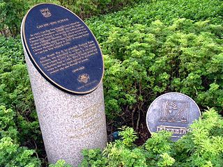
The Gan Eng Seng School's Founding Site, marked by twin commemorative plaques at present, is located at the junction of Telok Ayer Street and Cecil Street in the southern part of Singapore, near the Telok Ayer Chinese Methodist Church. On 30 August 1997, the site was designated as a national historical site along with five other schools by the National Heritage Board (NHB), being one of the oldest educational establishments in Singapore. The others are Raffles Institution, Raffles Girls' School, St Margaret's Secondary School, Singapore Chinese Girls' School and Anglo-Chinese School.

The Bukit Batok Memorial is located on top of the tranquil Bukit Batok Hill upon which once stood two war memorials built by Australian POWs to commemorate the war dead of the Japanese and the Allies who fought during the decisive Battle of Bukit Timah in Singapore during the Second World War. The two memorials were destroyed after the war and only the road and stairs that used to lead to them mark its legacy today.

Kent Ridge Park is a 47-hectare public park located in Kent Ridge, Singapore, between the National University of Singapore and the Singapore Science Park. Due to its undisturbed habitat and abundant plant life, it is a popular venue for bird-watchers and eco-tourists.

The Southern Ridges comprise 10 kilometres (6.2 mi) of trails connecting three parks along the southern ridge of Singapore. Some of the attractions along these trails include its greenery and the connecting bridges. This project linked up the parks between the Kent Ridge Park and HarbourFront. The idea to link these parks was coined in 2002 by Urban Redevelopment Authority (URA) and it took 2 years to complete and cost S$25.5 million.


Tanglin Halt is a public housing estate, planning subzone and former industrial estate in Queenstown, Singapore. Most of the older buildings in the estate are set to be demolished by 2024 to make way for redevelopments under the Selective En bloc Redevelopment Scheme. It is the third housing estate to be redeveloped under the scheme.
References
- 1 2 "Arcadia Road". National Parks Board. Retrieved 30 August 2016.
- ↑ "A Guide to Heritage Roads of Singapore" (PDF). National Parks Board. Retrieved 30 August 2016.
- ↑ Paulo, Derrick A. (26 January 2005). "Towards a city in a garden". Today . Retrieved 30 August 2016– via NewspaperSG.
- ↑ Lee, Min Kok (27 November 2015). "Get to know these 8 well-known Heritage Trees". The Straits Times. Retrieved 30 August 2016.
1°20′5″N103°48′36.6″E / 1.33472°N 103.810167°E
| | This Singapore road article is a stub. You can help Wikipedia by expanding it. |