Related Research Articles

Sweet Grass County is a county located in the U.S. state of Montana. As of the 2020 census, the population was 3,678. Its county seat is Big Timber. The county was founded in 1895.

Stillwater County is a county in the U.S. state of Montana. As of the 2020 census, the population was 8,963. Its county seat is Columbus.

Trout Creek is a census-designated place (CDP) in Sanders County, Montana, United States. The population was 261 at the 2000 census. Population increased to 277 per the United States Census [2020] Trout Creek was proclaimed "Huckleberry Capital of Montana" by the state's legislature in 1981.

The Little Bighorn River is a 138-mile-long (222 km) tributary of the Bighorn River in the United States in the states of Montana and Wyoming. The Battle of the Little Bighorn, also known as the Battle of the Greasy Grass, was fought on its banks on June 25–26, 1876, as well as the Battle of Crow Agency in 1887.

Battle Creek is a river that begins in the south-eastern region of the Canadian province of Alberta, near the border with Saskatchewan, in the Cypress Hills Interprovincial Park. From Alberta, Battle Creek flows east and across the border into Saskatchewan. It flows south out of Saskatchewan across the Canada–United States border into Montana, where it joins the Milk River in Blaine County, Montana.

The Gallatin River is a tributary of the Missouri River, approximately 120 mi (193 km) long, in the U.S. states of Wyoming and Montana. It is one of three rivers, along with the Jefferson and Madison, that converge near Three Forks, Montana, to form the Missouri.
There are 45 streams named Willow Creek in the U.S. state of Montana.
The Judith River is a tributary of the Missouri River, approximately 124 mi (200 km) long, running through central Montana in the United States. It rises in the Little Belt Mountains and flows northeast past Utica and Hobson. It is joined by Dry Wolf Creek in northern Fergus County, and itself joins the Missouri in the White Cliffs Area approximately 18 mi (29 km) northwest of Winifred.

DePuy Spring Creek is a three mile long trout fishery located between the Absaroka and Gallatin mountain ranges in Paradise Valley, south of Livingston, Montana. The creek is a small tributary of the Yellowstone River. This fishery supports a population of brown, Yellowstone cutthroat and rainbow trout.
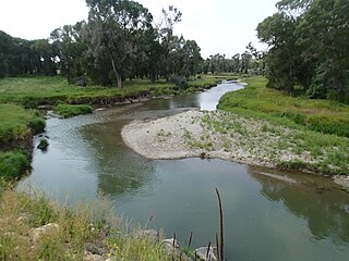
Roberts is a census-designated place and unincorporated town in Carbon County, Montana, United States. As of the 2010 census it had a population of 361.
Sheep Creek is a geographical place name. With variations, the name is given to hundreds of bodies of water, roads, canals, reservoirs and populated areas in the United States and other countries. It is the name of a tributary to Lockyear Creek in Queensland, Australia, and the name of at least three bodies of water in Canada. The U.S. state of Montana has 85 different locales that bear that name or a derivation. The U.S. state of Idaho has 92 natural and man-made areas that incorporate Sheep Creek into their names. Nature areas that include trails named Sheep Creek can be found in Canada's Yukon Territory, Colorado's Larimer County and in Utah's Bryce Canyon National Park.
Bloody Dick Creek is a stream in Beaverhead County, Montana, in the United States.
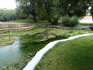
Big Spring Creek is a tributary of the Judith River in Fergus County, Montana near Lewistown, Montana. The creek originates from a first magnitude artesian spring approximately 6 miles (9.7 km) south of Lewistown and flows north, northwest for 30 miles (48 km) to its confluence with the Judith River. The spring is one of the largest in the world flowing at approximately 50,000 to 64,000 US gallons per minute out of the Madison-Limestone formation in the foothills of the Big Snowy Mountains. The creek flows through and under the town of Lewistown. For three blocks spanning Main Street, the creek runs underneath the town in a man-made channel that was created as the town was built over the creek. The spring provides Lewistown's water supply, which requires no treatment for use by consumers.
References
- ↑ U.S. Geological Survey Geographic Names Information System: Arch Creek (Montana)
- ↑ Marcuson, Pat (2008). Fishing the Beartooths: An Angler's Guide to More Than 400 Prime Fishing Spots. Globe Pequot Press. p. 59. ISBN 978-0-7627-4227-1.
45°9′29.33″N109°40′38.93″W / 45.1581472°N 109.6774806°W